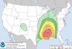
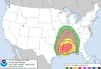
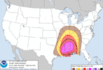
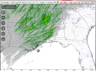
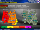
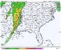
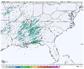
Going to be lots of power outages if that verifies.
-
Hello, please take a minute to check out our awesome content, contributed by the wonderful members of our community. We hope you'll add your own thoughts and opinions by making a free account!
You are using an out of date browser. It may not display this or other websites correctly.
You should upgrade or use an alternative browser.
You should upgrade or use an alternative browser.
Severe 3/30-4/2 Severe Weather
- Thread starter SD
- Start date
tennessee storm
Member
Off topic on this system. … it sure if it was mentioned , back 1984 today. Big tornado outbreak in the Carolinas ….
Darklordsuperstorm
Member
My mobile home is gonna be rocking Wednesday night!
MINE TOO!!!My mobile home is gonna be rocking Wednesday night!
HSVweather
Member
Mine too! Melba is coming over at 8. (I'll leave out the "she's gonna blow" joke since it's a family board)My mobile home is gonna be rocking Wednesday night!
RebelBearLandshark
Member
DAY 2 TEXT - GOT SOME STRONG WORDING
Day 2 Convective Outlook
NWS Storm Prediction Center Norman OK
1254 AM CDT Tue Mar 29 2022
Valid 301200Z - 311200Z
...THERE IS A MODERATE RISK OF SEVERE THUNDERSTORMS ACROSS PORTIONS
OF LOUISIANA...MISSISSIPPI...AND ALABAMA...
...SUMMARY...
A regional outbreak of severe thunderstorms is expected on Wednesday
across the Lower Mississippi Valley and Southeast States. All severe
hazards are possible, including significant gusts over 75 mph and
strong (EF2+) tornadoes.
...SEVERE-WEATHER OUTBREAK POSSIBLE ACROSS PORTIONS OF
LOUISIANA...MISSISSIPPI...AND ALABAMA...
...Synopsis...
A strong southern-stream shortwave trough is forecast to extend from
central KS through the TX Hill Country early Wednesday morning. This
shortwave is expected to progress eastward/northeastward throughout
the day, becoming increasingly negatively tilted as it does. Strong
mid-level flow will accompany this through, with 100+ kt at 500 mb
stretching from southeast TX northeastward through the Mid-South
Wednesday afternoon. Additionally, very strong low-level flow will
precede this feature, with a large area of 60+ kt at 850 mb expected
across the MS Valley Wednesday afternoon.
Low-level moisture advection will also precede this shortwave
trough, bringing at least low 60s dewpoints through the Mid-South/TN
Valley. Upper 50s dewpoints will likely reach into the Lower/Middle
OH Valley. These dewpoints will help foster at least modest buoyancy
and thunderstorms are anticipated as the shortwave ejects
northeastward over this moist and buoyant airmass. Given the
strength of the wind fields, severe thunderstorms are likely,
particularly across portions of the Lower MS Valley and Southeast
where a regional outbreak of severe thunderstorms is anticipated.
...Lower MS Valley into the TN Valley and Southeast...
A line of thunderstorms will likely be ongoing from the Ozark
Plateau southwestward into East TX early Wednesday. Expectation is
for this line of storms to quickly move eastward, outpacing a cold
front moving southeastward into the MS Valley. Widespread clouds
will limit diurnal heating downstream of this line of storms, but
strong moisture advection will still result in at least modest
buoyancy and airmass destabilization. At the same time, wind fields
will strengthen considerably. This combination of buoyancy and very
strong wind shear is forecast to result in a strengthening of the
line as it moves into eastern AR and LA during the early afternoon,
before then continuing quickly eastward across MS and AL during the
evening and overnight.
The kinematic fields, especially in the low-levels around 850 to 700
mb, are forecast to be very intense. Mean wind speeds from the HREF
show a corridor of 70 kt at 850 mb from central LA into southeast AR
at 18Z. Deep-layer mean winds are forecast to be 65+ kt across much
of LA, MS, and AL as the line moves through. Expectation is that
these robust wind fields will result in an intense convective line
capable of widespread wind damage. Embedded/QLCS tornadoes are also
likely within this environment, including the potential for strong
tornadoes (EF2+). Fast storm motion could result in longer-track
QLCS tornadoes than are typically observed.
In addition to the strong wind gusts and embedded QLCS tornadoes,
discrete supercells ahead of and/or south of the primary convective
line are also possible. Any discrete storm that is able to mature
and deepen would likely become an intense supercell capable of
producing severe wind gusts and strong tornadoes. However, the
forcing for ascent and fast-moving character of the shortwave (as
well as the convective line) do not favor a discrete convective
mode, and the current expectation is for the linear mode to
dominate.
..Mid MS and Lower/Mid OH Valleys...
Less low-level moisture and buoyancy is anticipated in the region
compared to farther south. However, strong forcing for ascent should
help maintain the convective line as it moves eastward through the
region. Strong wind fields support the potential for damaging wind
gusts with any deep convection, even in areas that exhibit shallow
low-level stability.
..Mosier.. 03/29/2022
VegasEagle
Member
TEXT FROM NWS BMX
National Weather Service Birmingham AL
401 AM CDT Tue Mar 29 2022
.SHORT TERM...
/Updated at 0327 AM CDT Tue Mar 29 2022/
Wednesday and Wednesday night.
* A significant damaging wind event is possible across Central
Alabama Wednesday afternoon into Wednesday night with straight-
line gusts of 60-70 mph. A few tornadoes are also possible.
* Non-thunderstorm wind gusts of 40-50 mph are possible during the
afternoon and evening ahead of the thunderstorm complex. This
could lead to tree fall and resultant damage to property and to
power outages.
By tomorrow morning, the trough to our west will amplify and begin
to swing from a positive to a more neutral tilt. An ongoing MCS will
then advance east from the ArkLaTex toward the lower Mississippi
Valley. By the afternoon, the shortwave is expected to swing to a
more negative tilt as both mid-level and low-level jets intensify.
The southerly LLJ will position across the Deep South during the
afternoon featuring 850 mb flow of 60-70+ kts, and 925 mb flow of 50-
55+ kts. A tight pressure gradient will combine with this strong LLJ
leading to windy conditions in the afternoon given expected BL
mixing. 40-50 mph gusts will be possible, and this could be quite
problematic given vulnerability to fallen trees in the region.
The LLJ will coincide with a narrow warm sector containing dewpoints
rising into the low to mid 60s, especially into the evening. Highest
values likely stay just ahead of the incoming MCS/QLCS. This
moisture will combine with afternoon heating to foster MLCAPE of 500-
750 J/kg across MS, where the system is expected to gain intensity
and forward speed. The combination of upper-level forcing/dynamics
and increasing instability within abundant kinematics will result in
a elongated area of thunderstorms capable of producing 60-70 mph
wind gusts. The robust LLJ will also support broad hodograph
curvature with 300-400 0-1 km SRH, and higher values in the 0-3 km
layer. Line-embedded bowing segments/circulations are likely - areas
where 0-3 km shear vectors can become line-normal in particular.
These features will lead to the greatest damaging wind threat, with
a few embedded tornadoes as well. Given the aggressive nature of the
MCS/QLCS, damaging wind gusts could be quite widespread across
Central Alabama throughout late Wednesday afternoon into Wednesday
night. At this time it appears areas along and north of I-59 have
the best dynamics/wind energy to work with, and it is here where the
most severe potential exists. However, instability continues to be a
limiting factor as it generally wanes in the evening. Areas west of
I-65 have the best chance of meaningful CAPE to promote stronger
thunderstorms/stretching. It is unclear how far east of I-65 the
warm sector can go before the convective system out runs it.
Nonetheless, all of Central Alabama is poised to see risk, and it
could be that wind energy/forcing overcomes limited instability for
most of our area. The convective line is expected to gradually
weaken later Wednesday night as forcing/dynamics aloft pull to the
north. This line should "lay over" and become more parallel to flow
aloft, slowing it`s progress and leading to areas of higher rainfall
potential along and south of I-85. The severe threat will continue,
however. By ~6 AM, the system should exit Central Alabama. 1-2" of
total rainfall is expected, with locally higher amounts. Some flash
flooding will be possible.
40/Sizemore
Z
Zander98al
Guest
That's pretty dang significant
Also! This moderate is from wind damage not tornadoes although stronger long lived tornadoes are a possibility within the line.
NWS is forecasting possible widespread wind damage and Spann is calling it a high empact event. Very strong wording for our area.That's pretty dang significant
Also! This moderate is from wind damage not tornadoes although stronger long lived tornadoes are a possibility within the line.
Z
Zander98al
Guest
Yeah I need to secure a lot of stuff by my house. Id consider residing in a structure built house or building, very strong straight line winds are just as akin to a weak tornado which can often lift and throw mobile homes.NWS is forecasting possible widespread wind damage and Spann is calling it a high empact event. Very strong wording for our area.
This is from James Spann morning discussion.
CALL TO ACTION: This has potential to be a high end wind event for much of Alabama; plan for power outages. Secure loose objects that might go flying away with strong winds. Pay close attention to severe thunderstorm warnings tomorrow night; if you live in a mobile home I would consider treating a severe thunderstorm warning like a tornado warning and be in a community shelter or business that is open and available as a shelter. Be sure you have two reliable ways of hearing warnings (NEVER a siren)… a NOAA Weather Radio and your phone; and be sure emergency alerts are enabled on your phone. Have the free ABC 33/40 weather app installed.
CALL TO ACTION: This has potential to be a high end wind event for much of Alabama; plan for power outages. Secure loose objects that might go flying away with strong winds. Pay close attention to severe thunderstorm warnings tomorrow night; if you live in a mobile home I would consider treating a severe thunderstorm warning like a tornado warning and be in a community shelter or business that is open and available as a shelter. Be sure you have two reliable ways of hearing warnings (NEVER a siren)… a NOAA Weather Radio and your phone; and be sure emergency alerts are enabled on your phone. Have the free ABC 33/40 weather app installed.
Z
Zander98al
Guest
That Alabama state line area could see a high risk upgrade for wind damage, that would be the most likely. It's been a longggggg while since we've seen a sizeable derecho. Last one I remeber was summer of 2012 I think?? But wasn't even that strong. I vaguely remeber something from around 2017 I think as wellThis is from James Spann morning discussion.
CALL TO ACTION: This has potential to be a high end wind event for much of Alabama; plan for power outages. Secure loose objects that might go flying away with strong winds. Pay close attention to severe thunderstorm warnings tomorrow night; if you live in a mobile home I would consider treating a severe thunderstorm warning like a tornado warning and be in a community shelter or business that is open and available as a shelter. Be sure you have two reliable ways of hearing warnings (NEVER a siren)… a NOAA Weather Radio and your phone; and be sure emergency alerts are enabled on your phone. Have the free ABC 33/40 weather app installed.
One thing that I (and a few others in my group chat) have been surprised at is how reluctant the SPC can be at times to upgrade risks when it is glaringly obvious that there's going to be a squall line with broad geographic coverage and the storm reports map is going to show a multi state area painted blue with some red dots and black squares. I've noticed they like to keep them at enhanced even though it's pretty likely a moderate risk will verify (or even high risk if you go by the by-the-book definition) and it's nice to see them respecting the potential here.
I am somewhat wary of the eastern sections of the board chances for mischief on Thursday- seems like another case where we are dependent on where the thickest convective debris goes.
I am somewhat wary of the eastern sections of the board chances for mischief on Thursday- seems like another case where we are dependent on where the thickest convective debris goes.
Probably because when the public thinks high risk they think tornado outbreak where their life is in peril vs a solid wind event that knocks out power and takes down a few trees. I believe you could get a good derecho with 200 reports of 60mph, but unless you have lots of trees fall on cars and houses the public would think a High risk would be a bust.One thing that I (and a few others in my group chat) have been surprised at is how reluctant the SPC can be at times to upgrade risks when it is glaringly obvious that there's going to be a squall line with broad geographic coverage and the storm reports map is going to show a multi state area painted blue with some red dots and black squares. I've noticed they like to keep them at enhanced even though it's pretty likely a moderate risk will verify (or even high risk if you go by the by-the-book definition) and it's nice to see them respecting the potential here.
I am somewhat wary of the eastern sections of the board chances for mischief on Thursday- seems like another case where we are dependent on where the thickest convective debris goes.
Last edited:
Darklordsuperstorm
Member
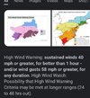
The key takeaway for me is that wind is now the leading threat across the board for them. Anyone think we actually will see a high wind watch/warning ahead of the line or will they likely stick with the advisory?
Z
Zander98al
Guest
Probably stick with wind advisory, Idk know the criteria but there is such things as a pds watch for severe winds I think..The key takeaway for me is that wind is now the leading threat across the board for them. Anyone think we actually will see a high wind watch/warning ahead of the line or will they likely stick with the advisory?
Just read it's usually for derechos so you may see a watch for that
I'm still under a Slight Risk for Today, odd.
Also, even if it's without the storms, I've heard that some models, (Posted on a different forum) have wind gusts up to Hurricane Force (Not Thunderstorm Enhanced) in the OV & down into Alabama as up to 50-60 mph gusts.
And Thunderstorm wind gusts could get up to 100 mph. A High Risk for that is not out of the question.
Last edited:
So what phenomenon is this going to be called? The Will Smith b-slap zone?
Last edited:
Darklordsuperstorm
Member
This is a discussion from Fred Gossage about tomorrows event:
But I do think a couple of tornadoes in the QLCS may be EF2 or maybe up to lower EF3 (we see that a good bit more often than a lot of people like to admit), and because of the fast storm motions, tornadoes of any intensity in the line may be a slight touch longer-tracked than they otherwise would be. But even if there are a couple of strong tornadoes in the line, the big deal tomorrow is going to be the widespread 70-80 mph wind swath with what will probably be a serial derecho
But I do think a couple of tornadoes in the QLCS may be EF2 or maybe up to lower EF3 (we see that a good bit more often than a lot of people like to admit), and because of the fast storm motions, tornadoes of any intensity in the line may be a slight touch longer-tracked than they otherwise would be. But even if there are a couple of strong tornadoes in the line, the big deal tomorrow is going to be the widespread 70-80 mph wind swath with what will probably be a serial derecho
Darklordsuperstorm
Member
This one gives me vibes of a system we had a year or two ago that came in during the fall/winter season. It was also a widespread long track derecho type system. It was very well warned and forcast
925mb winds of 50-65kt 850mb winds of 60-85kt aren't going to take a lot to mix down. Add in some potential for increasing fwd momentum with the line and we are going to see a number of 65-75 mph gusts with 80-90 not out of the question
HSVweather
Member
When was the last true by definition derecho in Alabama? 28-June-2018? Don’t most derechos occur in summer months from a NW flow aloft? It seems to be relatively rare to have a derecho in the spring. By definition a derecho should have consistent damage reports at severe criteria for 240 miles or approximately Clarksdale Ms to Huntsville AL.
HSVweather
Member
According to SPC the derecho definition is
“By definition, if the swath of wind damage extends at least 400 miles (about 650 kilometers), is at least 60 miles (about 100 km) wide, includes wind gusts of at least 58 mph (93 km/h) along most of its length, and also includes several, well-separated 75 mph (121 km/h) or greater gusts, the event may be classified as a derecho.”
Regardless, it doesn’t have to be a derecho to cause a lot of wind damage. I was just curious after seeing several Mets mention derecho potential.
NWMSGuy
Member
Z
Zander98al
Guest
Only one I can truly remeber is 2012 cause I was outside in it lol. There's been a few here and there but for north and central Alabama have had some since 2012 but minor and usually skirts the stateWhen was the last true by definition derecho in Alabama? 28-June-2018? Don’t most derechos occur in summer months from a NW flow aloft? It seems to be relatively rare to have a derecho in the spring. By definition a derecho should have consistent damage reports at severe criteria for 240 miles or approximately Clarksdale Ms to Huntsville AL.
NWMSGuy
Member
Z
Zander98al
Guest
That's why this setup is kinda crazy. Potential for ef2/ef3 spin ups from a super fast moving line.Lots of spin potential tomorrow:
View attachment 116409
Likely have a strong tornado one minute and gone the next, nearly impossible to keep up with.
NWMSGuy
Member
May be wrong here but I wouldn't be surprised to see that Moderate Risk expanded more Northward to include portions of AR & TN.
Wednesday's forecast, from many sources, is including a strong risk of high straight line winds. Does the NWS use the word "derecho" in forecasting? Is damaging straight line winds associated with a QLCS across a large area considered a derecho, or are those born from a different type of synoptic setup?
Z
Zander98al
Guest
A derecho is a QCLS, it only gets a derecho name once it's reached criteria of range of damage and length. So the nws probably is referring to that but I imagine saying QCLS Is more scientifically correct lol, cause it hasn't done it yet.Wednesday's forecast, from many sources, is including a strong risk of high straight line winds. Does the NWS use the word "derecho" in forecasting? Is damaging straight line winds associated with a QLCS across a large area considered a derecho, or are those born from a different type of synoptic setup?
That makes sense. I did not realize there was criteria in place to define a wind event as a derecho. thank you!A derecho is a QCLS, it only gets a derecho name once it's reached criteria of range of damage and length. So the nws probably is referring to that but I imagine saying QCLS Is more scientifically correct lol, cause it hasn't done it yet.
RollTide18
Member
This won’t be fun, fully expecting to lose power tomorrow night, got my flashlights and everything though.
Z
Zander98al
Guest
That northwest quadrant of Alabama really needs a high risk just from a quick glance that area is going to get knocked.
Yeah I’m going to crank the generator this afternoon to make sure it is in good shape. Probably will pick up some extra batteries and fill up couple of gas cans tomorrow just in case. I hate storms that come thru during the night.This won’t be fun, fully expecting to lose power tomorrow night, got my flashlights and everything though.

