Z
Zander98al
Guest
Oof
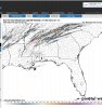
Wow. Taken verbatim, the higher tornado threat extends north through TN to around the KY state line. Pretty large area going to be involved in this tomorrow.
as far as number of tornadoes, yes, but I believe that is largely a function of increased surveying capabilities, etc. The system didn't produce a tornado greater than EF2 and the outbreak was virtually non existent in MS where the 'bullseye' of the high risk was placed. I would go on to say that a high risk predicated on strong violent long track tornadoes not producing such would be considered somewhat of a not living up to its potential.I mean last week kinda did, I think last week people were expecting several wedge tornadoes and EF5s to hit homes and cities, and I guess since it didn’t, it was a bust, but the 45% area verified in AL, some of the FB posts are downright ------ stupid towards spann
last week I never really bought the hype. This system look far more concerning. Only problem is that the public is going to be somewhat complacent due to last weeks system not living up to it's broadcasted potential

Probably 2am tommorow in the next update I imagine. Or atleast I think 2 am is when they update. Don't see reason why high risk wouldn't be issued at this pointWhen is this thing going high risk? Seems to be headed that way.

What kind of weather we will see further east into GA/SC/NC?

DAMN SON!!!

Sent from my iPhone using Tapatalk

These are way too high I would think. Contamination as @Arcc has mentioned
Enhanced risk for today incoming from the SPC.
Looks to be just SE of DFW, but does include Austin and San Antonio.


Lol yeah but it's cool looking at all the bright colors modernweenieThese are way too high I would think. Contamination as @Arcc has mentioned


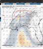
I'm assuming anything in green or brighter color should be of concern?That's nassssttyyy View attachment 80202
I'm assuming anything in green or brighter color should be of concern?

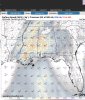
Both WRF focus on the boundary across north central AL. That is a very dangerous place to be tomorrow if it verified.
Edit: This one actually needs a high risk.