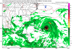
Ukmet I think. It's always been a western outlier in other storms
The GDAPS/UM isn’t the UKMET and it like NAM not surprisingly isn’t taken seriously for strength.
Ukmet I think. It's always been a western outlier in other storms
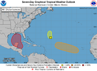
Circle stayed the same....Northwestern Caribbean Sea and Gulf of Mexico:
A broad area of low pressure should form during the next few days
over the northwestern Caribbean Sea and the adjacent portions of
Central America. Thereafter, gradual development of this system is
expected, and a tropical depression is likely to form as the system
moves slowly northward across the northwestern Caribbean Sea and
Gulf of Mexico through the end of next week. Regardless of
development, this system is expected to produce heavy rains over
portions of Central America during the next several days.
* Formation chance through 48 hours...low...near 0 percent.
* Formation chance through 7 days...high...70 percent.

It will miss by the time it’s said and done! The season has been dead since February!
GFS still has nothingNow the CMC 12z is showing storm 2 in the same starting position as storm 1.
View attachment 151512 a
I would imagine the waters would be cooler after Helene moves through ?Now the CMC 12z is showing storm 2 in the same starting position as storm 1.
View attachment 151512 a
No doubt but warm enough for a caneI would imagine the waters would be cooler after Helene moves through ?
Warm enough to take out anything left from the first one......if there is anything left.I would imagine the waters would be cooler after Helene moves through ?
Will be interesting to see where they development and eventually steer if they come to fruition.


GFS goes bonkersThe latest Euro Weeklies mean went absolutely bonkers for the week of 10/7-13. It has a whopping 340% of 2004-2023 averaged ACE or ~23! (see top image below). This is well over peak week climo of 16, which is 4 weeks earlier! This is easily the single highest week I could recall for any single week of Euro Weeklies for the season to date! The 2nd image shows where the bulk of the activity is expected: Gulf, N Caribbean, Bahamas, Bermuda, and much of the W and C subtropical Atlantic.
Going back to 1991, I could find only two seasons with ACE anywhere close to 23 during Oct 7-13:
-2018’s ~24 due mainly to Leslie and Michael
-2016’s ~18 due to Matthew and Nicole
So, the latest Weeklies are calling for Oct 7-13 to be just about tied with 2018 for the most active since 1991. That’s very notable for a 100 member ensemble mean.
In addition the run’s mean for the week prior, 9/30-10/6 is at 180% of 20 year climo or 17. So, after Helene gets ACE and the E MDR get ACE up to ~75, an additional 40 is progged for the subsequent two weeks. That would bring ACE up to ~115 with the last half of Oct and Nov still left. The same run is progging another 15 for 10/14-27, which would get it to 130. If this were to verify closely, a 150ish total season ACE would not be far fetched considering the warmth of the Atlantic and the strengthening Niña.
View attachment 151723
View attachment 151724

If that were to happen the flooding would be severe for inland areas.View attachment 151831Almost the same path. freaky
Waste of a name. They should have ignored it.I storm won't be making history this yearView attachment 151902
Waste of a name. They should have ignored it.
