NoSnowATL
Member
Faster vs slower. Who will win out? cant bet against the east movement.
Last edited:
Faster vs slower. Who will win out? cant bet against the east movement.

Icon, Euro, and AI got that west movement going on. And they don't seem to be moving away from it yet. GFS and CMC are quite stubborn with the east pull. As usual, we gotta wait to see where the center starts and how strong.Faster vs slower. Who will win out? cant beat against the east movement.

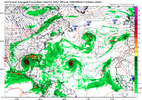
18z GFS ensembles.....not much of a change from 12z, but seeing some pink lines.....that's not good.
View attachment 151253

Gfs initiating much further eastView attachment 151254


I think it depends on how fast it moves as wellAlthough there’s a general alleyway northward into the Gulf here, the overall steering pattern next week is highly uncertain with this big rex block developing over the east-central part of N America.
Regardless, there’s a very good chance whatever forms out of this is going to be gigantic because of its origins out of the monsoon gyre. The large initial disturbance coupled with low background pressures and the very moist environment around it will strongly favor radial expansion of the storm over intensification to a large degree. That along with land interaction might be its biggest impediments to further intensification/development. Not necessarily a good thing lol
View attachment 151266
No strong trough to turn it north and east. Unless something changes, a north and west drift and then north is favored imoI think it depends on how fast it moves as well
Although there’s a general alleyway northward into the Gulf here, the overall steering pattern next week is highly uncertain with this big rex block developing over the east-central part of N America.
Regardless, there’s a very good chance whatever forms out of this is going to be gigantic because of its origins out of the monsoon gyre. The large initial disturbance coupled with low background pressures and the very moist environment around it will strongly favor radial expansion of the storm over intensification to a large degree. That along with land interaction might be its biggest impediments to further intensification/development. Not necessarily a good thing lol
View attachment 151266


Interpretation: it's gonna be a bad ass storm.....lolAlthough there’s a general alleyway northward into the Gulf here, the overall steering pattern next week is highly uncertain with this big rex block developing over the east-central part of N America.
Regardless, there’s a very good chance whatever forms out of this is going to be gigantic because of its origins out of the monsoon gyre. The large initial disturbance coupled with low background pressures and the very moist environment around it will strongly favor radial expansion of the storm over intensification to a large degree. That along with land interaction might be its biggest impediments to further intensification/development. Not necessarily a good thing lol
View attachment 151266
.png")


Thank God! Saves me a ton of time so I don't sort through stuff that doesn't matter. I'm sure all the folks who don't really care to learn about it, but need the info once a year, appreciate it too.Who needs a model website when it's all right here!
Well, that GFS storm isn't the way to get it. All I see with that is flash flooding.I do not want death and destruction, but the interior SE, N GA, ATL metro, is desperately dry, we need this asap.
.png")
Well, that GFS storm isn't the way to get it. All I see with that is flash flooding.
Need a center and what will that H do. Two big questions we will have to wait on.Yeah I don't even want to imagine the flooding if the 0z GFS verified... 5 days in the Gulf at that size...
Luckily it's a model run a week out because that's one of the worst runs I've ever seen