lexxnchloe
Member
James Spann just said that that it will probably be a cold core system
Thats possible storm 2 11 days from nowJames Spann just said that that it will probably be a cold core system
Hopefully since it's a hybrid at best it can utilize that and actually get a bit of wind over a larger area. Could see some widespread 40+ gusts with that gradient to its north.Well this is pretty much it lets see what it can do View attachment 151057
Hopefully since it's a hybrid at best it can utilize that and actually get a bit of wind over a larger area. Could see some widespread 40+ gusts with that gradient to its north.

Actually looks better than I thought it would at this point, the MLC continues to drift SE towards the area of lower surface pressures. There is a lot going on out there and frankly it is a mess and probably does not have the kind of time it would need to become anything more than a weak named storm.

Wouldn't be surprised if new hanover and brunswick county did if it comes in like the gfs shows. Wilmington is horrible for flooded roads.Wonder if the Monday system will be bad enough to close schools.
That's the Ian path.....
Gefs is very active for the western Caribbean with different splits on where it all ends upThat's the Ian path.....
Looks like Euro AI and GFS show it developing on 9/24. Icon is not going out that far yet.Gefs is very active for the western Caribbean with different splits on where it all ends up
Looks like the crazy nam is back to being crazy for this low off the coast. Year after year the nams always go extreme during all seasons
3k had it low 980 a frame orn2 before weakening it again. Doesn't really matter cause the nams just aren't matching most other modelsMid to upper 990's isn't that crazy...
Looks like the crazy nam is back to being crazy for this low off the coast. Year after year the nams always go extreme during all seasons

The Winds should be weak as it will be a weak system but like you said the gradient should allow this to at least perform up to expected winds. Could see an overperformer on the north side if it remains subtropical and has a larger wind field on the north side amd that gradient really packs in1. This system could probably use its own thread imho.
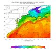
2. The extratropical LLC is near 31.5N, 76.5W. Below is the latest SST map. The LLC is over 84F water in the Gulf Stream. On the progged path, it will cross water as warm as 85 in the middle of the GS. But then SSTs fall sharply to BN at the coast of the Carolinas (77-78) thanks to recent BN temps/clouds. I’d think that would help keep the storm from being too strong at landfall should it become tropical with the peak perhaps before landfall. My guess is a 995 mb TS at landfall with winds increased due to the tight gradient vs the NE US high:
View attachment 151087
Ground is Saturated here in Pender, Will not take much..Wouldn't be surprised if new hanover and brunswick county did if it comes in like the gfs shows. Wilmington is horrible for flooded roads.
