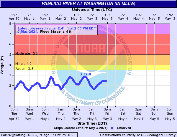
• Hello, please take a minute to check out our awesome content, contributed by the wonderful members of our community. We hope you'll add your own thoughts and opinions by making a free account!

Tropical 2023 Tropical thread

Status
Not open for further replies.
Wave in the Bahamas has started to organize as it heads into the FL. Straights.

System appears to be gradually organizing over the past few hours, and an LLC appears to be developing SSE of Miami. Definite mid-level and upper-level vorticity over this area per satellite. Over the last several hours in Ft. Lauderdale, winds have picked up to 15-25 MPH. The Lower Level Clouds are moving quicker through the sky. There's an increasing chance that the system wraps up tomorrow morning.
 
System appears to be gradually organizing over the past few hours, and an LLC appears to be developing SSE of Miami. Definite mid-level and upper-level vorticity over this area per satellite. Over the last several hours in Ft. Lauderdale, winds have picked up to 15-25 MPH. The Lower Level Clouds are moving quicker through the sky. There's an increasing chance that the system wraps up tomorrow morning.

Meh. Even the 3k NAM doesn't do much with it. Could be some decent rain for TX though.


Sent from my iPhone using Tapatalk
 
To be honest that system that comes out of the carribbean could be slightly more intriguing. If it doesn't get captured by that trough and shoved several hundred miles east as depicted there then the building high could get it closer to the coast. That's what the 06z shows with a threat to NE and Canada.

It's the only small narrow window to get something interesting to track. It has to avoid that northeast turn for that long
It's always about the placement of the turn. Stronger or weaker could stay more west or would it even matter?
 
Also watch TVCN/X-----thats where NHC will go with their forecast.
And the GFS ensemble took a bit of scramble from last night.

90L_tracks_latest (1).png

90L_gefs_latest (1).png
 
It's always about the placement of the turn. Stronger or weaker could stay more west or would it even matter?
It always matters to some degree. Look back at Florence when she was way out forecast to make the turn but ended up missing the trough. The models literally had a 900 mile shift in just a few runs.
 
Well the 12z euro is interesting
Yep
ec-fast_z500_mslp_us_11.png
 
Not the easiest way to get there with the parent vort getting started in the pacific jumping central America then getting going in the carribbean/gulf. Historically these system has stayed in the pacific or gotten so tangled in C America/Yucatan there's not much consequence
 
Status
Not open for further replies.
Back
Top