Henry2326
Member
06z GFS Para


.gif")


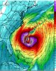
There it is, the super snowblizzardcane of 2020!GFS has trouble near South Florida in fantasy land.View attachment 50253

Taking verbatim from that run, It doesn't look like I can change my profile picture back to the traditional Ollie anytime soon. smhThe Happy Hour GEFS is saying that 2020 will have a good chance to be only the 3rd season on record going back to 1851 with 3 October W Caribbean geneses. The other two are 2005 (3rd one was Beta with genesis on 10/26) and 1870 (3rd one had genesis on 10/29). So, 2020 would by a good number of days have the earliest 3rd Oct W Car genesis on record:
Not sure there could be a worse run than the 06z GFS.


12z EuroAnother area off the east coast on the EPS to possibly watch as well as the very beginning of something in the Caribbean
View attachment 50355


Now that is a massive storm ! These gulf storms have been tight and strong but this.... strong and massive .