-
Hello, please take a minute to check out our awesome content, contributed by the wonderful members of our community. We hope you'll add your own thoughts and opinions by making a free account!
You are using an out of date browser. It may not display this or other websites correctly.
You should upgrade or use an alternative browser.
You should upgrade or use an alternative browser.
Tropical 2020 Atlantic Hurricane Season Discussion
- Thread starter Snowfan
- Start date
This EPS run is easily the most active yet, especially for 10/7-12.
View attachment 49440
Edit: I count ~30% of the 51 members that go sub 1000 mb vs the highest on any prior run being closer to 22%.
They appear to be centering genesis chances around 10/6-7.
The subsequent two runs, the 0Z/12Z EPS of today, dropped back from ~30% to ~20%.
6z GFS is a disaster for s/e up into western Carolinas. Ivan like...
Latest CMC joins the party with hurricane strengthening in the north eastern Gulf of Mexico
6z gfs would be nasty for Atlanta too..right side severe and floods
Para makes the most sense to me tho, shots the gap as a strong hurricane and only impacts Florida, very climo like for October
Dawgdaze22
Member
Para makes the most sense to me tho, shots the gap as a strong hurricane and only impacts Florida, very climo like for October
I don’t have access to tropical tidbits at the moment do you mind sharing?
Sent from my iPhone using Tapatalk
Henry2326
Member
Henry2326
Member
Dawgdaze22
Member
Is that a TS/Low grade category 1?
Sent from my iPhone using Tapatalk
Henry2326
Member
Yup....but too far out for the model to get it right. I personally think if I takes that route, it won't be pretty.Is that a TS/Low grade category 1?
Sent from my iPhone using Tapatalk
Dawgdaze22
Member
Yup....but too far out for the model to get it right. I personally think if I takes that route, it won't be pretty.
Yeah i would think it’d be a bit stronger.
Sent from my iPhone using Tapatalk
Henry2326
Member
Both GFS and Para continue to have a second storm in the back end of the run.
Henry2326
Member
Henry2326
Member
I’m favoring strong hit west coast of Florida...the only untouched part of the US this season without any tropical watches/advisories for the Atlantic hurricane season.
Henry2326
Member
Wave is looking good usually it’s a graveyard there
lexxnchloe
Member
BufordWX
Member
Brent
Member
00z GFS targets Florida and then the Carolinas. I believe this is the wave after the one the NHC is currently monitoring. Of course it is pretty far out still as well.View attachment 49554
Quite a run there
accu35
Member

Here’s the wind map, if you wanted to edit your post in the archive thread.00z GFS targets Florida and then the Carolinas. I believe this is the wave after the one the NHC is currently monitoring. Of course it is pretty far out still as well.View attachment 49554

Henry2326
Member
Henry2326
Member
The interaction with the front could push heavy rain well out ahead of the storm (much like Opal in ‘95), and with a trough diving in you would expect any storm there to move very quickly as well which means wind impacts would be spread hundreds of miles inland like both Opal and Michael.I would really pay attention as this has a chance to be a northern gulf coast hit before the front pushes in.
This has a chance to destroy the fall foliage season for the Carolinas. Perfect timing.
and I hate that because I’m supposed to spend the following weekend near Maggie ValleyThis has a chance to destroy the fall foliage season for the Carolinas. Perfect timing.
Henry2326
Member
Henry2326
Member
Henry2326
Member
Man the upslope would be killer. Would likely break state yearly record for NC given areas already in the top 5 I think Highlands is
This has it hitting the same place as Michael 2 years to the day (Oct. 10th)
Henry2326
Member
Gulf Shores did the same.....history keeps repeating....This has it hitting the same place as Michael 2 years to the day (Oct. 10th)
Henry2326
Member
Tornadocane
Member
Is Paulette still out there west of the Canary Islands?
Henry2326
Member
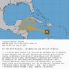
Code Red


ZCZC MIATWOAT ALL
TTAA00 KNHC DDHHMM
Tropical Weather Outlook
NWS National Hurricane Center Miami FL
800 PM EDT Wed Sep 30 2020
For the North Atlantic...Caribbean Sea and the Gulf of Mexico:
1. A tropical wave located over the west-central Caribbean Sea is
expected to continue moving westward over the next couple of days,
and produce a broad area of low pressure over the western Caribbean
Sea or extreme southern Gulf of Mexico by Thursday night or Friday.
Environmental conditions are forecast to be conducive for some
development thereafter, and a tropical depression could form over
the weekend while the system moves slowly west-northwestward over
the northwestern Caribbean Sea. Interests in Belize, the Yucatan
Peninsula, and western Cuba should monitor the progress of this
disturbance.
* Formation chance through 48 hours...low...20 percent.
* Formation chance through 5 days...high...70 percent.
2. Another tropical wave located a few hundred miles east of the Lesser
Antilles is producing widespread cloudiness and disorganized shower
activity. This disturbance is forecast to move westward during the
next several days where environmental conditions could become a
little more conducive for development over the central or western
Caribbean Sea by early next week.
* Formation chance through 48 hours...low...near 0 percent.
* Formation chance through 5 days...low...20 percent.
Forecaster Stewart


