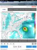
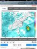
• Hello, please take a minute to check out our awesome content, contributed by the wonderful members of our community. We hope you'll add your own thoughts and opinions by making a free account!

Tropical 2019 Atlantic Hurricane Season & Model Discussion

0z Icon
icon_mslp_pcpn_frzn_seus_60.png
 
Jimmy, were already losing it West! This is gonna go right up through AR and MO, and give them more flooding, while I bake! I knew being in the 10 day out bullseye on the Euro yesterday, was the KOD!?
 
The rich get richer, SMFH
 
SSTs are boiling in the GOM rn, wind shear and lots of SAL around the MDR is preventing anything atm, but man if wind shear/SAL would go away, those water temps are supportive of a cane, a strong one at that, but ofc when there actually is one there’s other factors, but man there’s many areas along the Florida coast (gulf side) seeing 90+ water temps, which is a little unusual, don’t like that at all View attachment 20684View attachment 20685View attachment 20686

If there that warm now what’s it going to be like in September?
 
Something to keep in mind. While the GOM is warm, especially the Eastern half, the heat content is still pretty meager as is the 26C isotherm so it would be hard as things stand currently to support a strong hurricane since mixing would be a big issue at this point in the season.

1562416380211.gif

The heat potential in the Eastern GOM is actually pretty low. 1562416437707.jpeg
 
Something to keep in mind. While the GOM is warm, especially the Eastern half, the heat content is still pretty meager as is the 26C isotherm so it would be hard as things stand currently to support a strong hurricane since mixing would be a big issue at this point in the season.

View attachment 20820

The heat potential in the Eastern GOM is actually pretty low. View attachment 20821

Different setup, but the TCHP wasnt much more last year when we took a hit from a Cat 5. Really just depends on size and movement.
 
The euro is bullish again

View attachment 20818

984 mb inland!!! Definitely Hurricane Barry on the Euro

View attachment 20819
Definitely going to be something to watch. The Euro wants to keep it in the Gulf for a few days which can really make it a strong hurricane, but other models like the GFS just keep it a low pressure that stalls over land. Regardless, this is going to bring a big tropical inflow into the SE mainly along the Gulf coast.
 
Different setup, but the TCHP wasnt much more last year when we took a hit from a Cat 5. Really just depends on size and movement.

Yeah but that was later in the season and the 26C isotherm was a good bit deeper than it is right now. Forward speed and size of the wind field also plus a big role too. Thankfully if anything did develop and moved slow the mixing would definitely limit it at this time of the year.
 
Yeah but that was later in the season and the 26C isotherm was a good bit deeper than it is right now. Forward speed and size of the wind field also plus a big role too. Thankfully if anything did develop and moved slow the mixing would definitely limit it at this time of the year.
Bigger issue than either of those will probably be upwelling due to the potential storm being over or near shallower shelf waters.
 
Tropical Weather Outlook
NWS National Hurricane Center Miami FL
200 PM EDT Sat Jul 6 2019

For the North Atlantic...Caribbean Sea and the Gulf of Mexico:

1. A trough of low pressure over western Kentucky, Tennessee and
northern Mississippi is forecast to move over the northeastern Gulf
of Mexico where a low pressure area could form early next week.
Some gradual development of the system is then possible as it drifts
westward over the northern Gulf of Mexico through midweek.
* Formation chance through 48 hours...low...near 0 percent.
* Formation chance through 5 days...low...20 percent.

Forecaster Blake


two_atl_5d0.png
 
Bigger issue than either of those will probably be upwelling due to the potential storm being over or near shallower shelf waters.

Yeah that’s what I meant by the mixing, the cooler waters below upwelling and cooling the surface down a bit. I don’t think we would see much if anything develops, especially if it’s a slow mover, but could see a decent TS if things came together.
 
Tropical Weather Outlook
NWS National Hurricane Center Miami FL
200 PM EDT Sat Jul 6 2019

For the North Atlantic...Caribbean Sea and the Gulf of Mexico:

1. A trough of low pressure over western Kentucky, Tennessee and
northern Mississippi is forecast to move over the northeastern Gulf
of Mexico where a low pressure area could form early next week.
Some gradual development of the system is then possible as it drifts
westward over the northern Gulf of Mexico through midweek.
* Formation chance through 48 hours...low...near 0 percent.
* Formation chance through 5 days...low...20 percent.

Forecaster Blake


View attachment 20830
Track seems locked in stone!?
 
Back
Top