Henry2326
Member
What's interesting, is in 12z it takes a low west from the same spot. The low in that spot around the 14th appears to be the origination point.Here we go again with the fantasy storms.

What's interesting, is in 12z it takes a low west from the same spot. The low in that spot around the 14th appears to be the origination point.Here we go again with the fantasy storms.
Larry,MJO phase at genesis for 19 TCs since 1975 that were in Caribbean/GOM & later hit CONUS Oct-Nov: (C = inside circle)
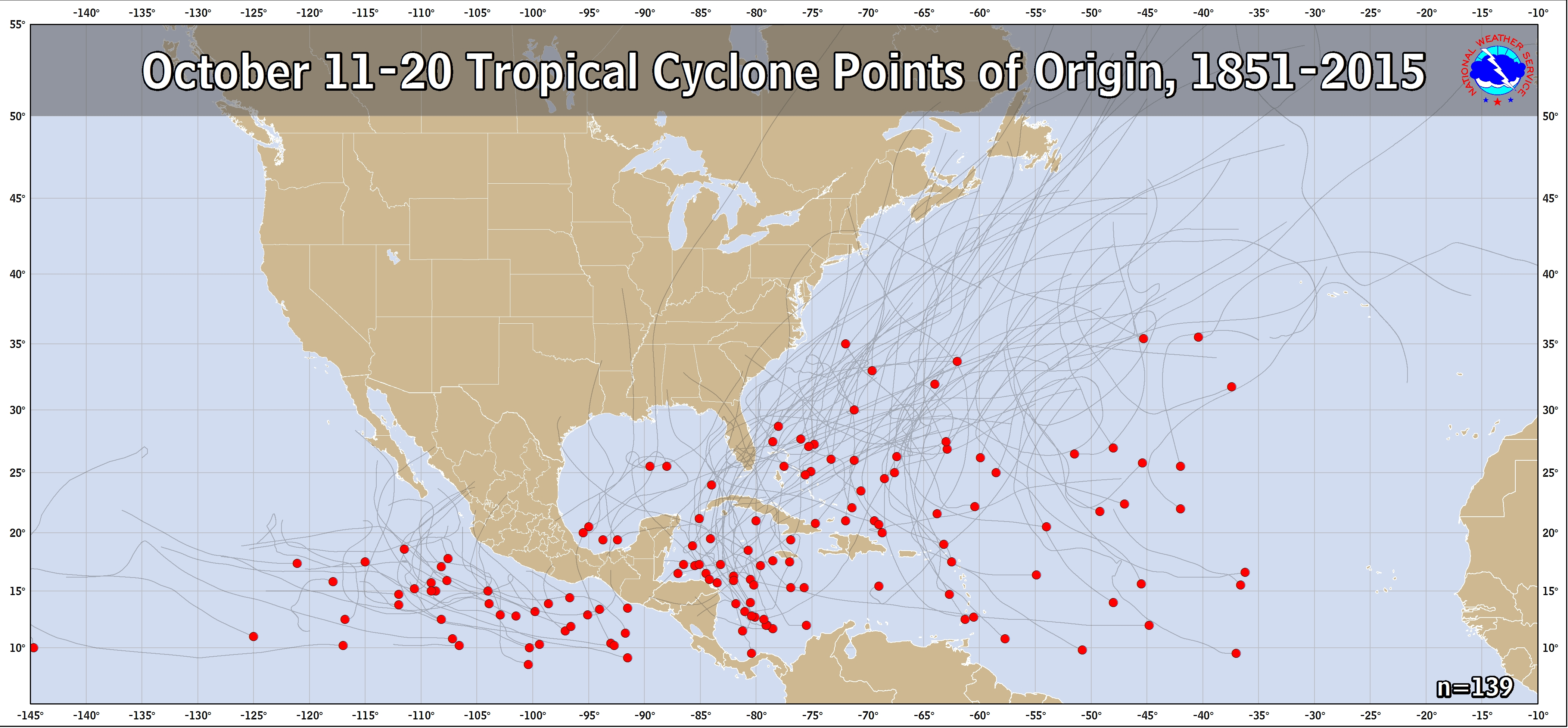
Does anyone see any tendency?
1985: Juan 8
1985: Kate 5
1987: Floyd 4 (C)
1988: Keith 2 (C)
1989: Jerry 4
1990: Marco 1
1994: Gordon 2
1995: Opal 5 (C)
1996: Josephine 1 (C)
1998: Mitch 8 (C)
1999: Irene 2 (C)
2002: Lili 1 (C)
2004: Matthew 5
2005: Wilma 4
2009: Ida 2
2012: Sandy 2
2016: Matthew 5
2017: Nate 1 (C)
2018: Michael 1
Out of these 19, # of geneses within each MJO phase
Phase 1: 5 (2 outside circle)
Phase 2: 5 (3 outside circle)
Phase 3: 0
Phase 4: 3 (2 outside circle)
Phase 5: 4 (3 outside circle)
Phase 6: 0
Phase 7: 0
Phase 8: 2 (1 outside circle)
")
What would this mean for us along the SE coast?Larry,
You and I focus on MJO ... for a reason ...

12z Gfs has something southwest of Jamaica at hour 150.View attachment 24305

Now happy hour has a hurricane hitting Belize next week.View attachment 24319
Easy. Make no radical changes to the forecast due to inconsistencies.So, how are forecasters going to handle this??
Its about time.....
ILL TAKE IT. JUST NEED IT TO BE MORE WEST.. SAY JUST WEST OF THE MS/AL LINE AND HEAD DUE NORTH TO TN1. Landfall of 1001 mb on 10/20 on the 0Z GFS.
2. Landfall of cat 2ish H W FL Pan on 10/19 on 0Z CMC (take with a humongous grain):

Lol temps in the 20s that scour out just in time. Not far off from some initial “mix to rain” for Virginia too. I call bs on hurricane or temps.1. Landfall of 1001 mb on 10/20 on the 0Z GFS.
2. Landfall of cat 2ish H W FL Pan on 10/19 on 0Z CMC (take with a humongous grain):


Icon appears to be aligning with UKMET.Believe it or not, the tropical wave still inside Africa may not be the only CV wave that could become a TC. Although with a somewhat low probability of development as of now but of potentially much more concern should it develop, there's a sleeper wave not yet mentioned by the NHC located ~500 miles W of the CVs moving WSW. Although it would be quite unusual so late, the 12Z model consensus (Euro, UKMET, GFS, ICON, CMC) brings at least the vorticity/moisture from this all of the way across to near or north of the L Antilles by a week from now! Some models even form a weak sfc low from this by the end of this weekend. Going out further, the Euro and CMC takes this energy to just north of Hisp at 240 and in a position that could threaten the SE US due to a strong ridge to its north. There are actually 2 EPS members out of 51 that hit FL on 10/23. Also, out of 21 CDN ensemble members, 5 hit or skirt the SE US: 4 skirt some of the SE US coast 10/22-4 and 1 goes around and then hits SW FL on 10/26. In addition, a 6th member is still drifting westward over Cuba and in a threatening position at 384 (10/27).
Here are some maps:
1. 12Z UKMET has concentrated 850 vorticity located near 10N, 44W Sun evening:

2. 12Z UKMET then moves this WNW to just E of the Windwards next Thu morning (also note the track up to that point):

3. 12z CMC 240 has the low between Hisp and Cuba underneath a strong ridge moving WNW:
4. 12Z CMC ensembles hour 276: note the 4 members near or just E of FL (Also, 2 later members: one hits Cuba and other SW FL)


To your point about wind shear.....There seemed to be a bit of a low level circ per the last vis pics. But what IR loops suggest to me is moderate SW shear. Per models, SW to W 200 mb winds will be present through the entire trek toward the Lesser Antilles, which I assume is common in mid Oct and is probably why activity out there this late is typically limited despite very warm SSTs. The shear isn’t progged to get high but it is likely high enough to be the reason models are keeping this to no more than a weak sfc reflection all the way to the LAs.
This sleeper wave will be interesting to follow next week due to the unanimous model support to get it to the western basin. Will there then be much of anything left to it then? The Euro suite, the best out there, says no. Also, GEFS is very quiet. So, despite the 12Z CMC’s Central Caribbean H at the end of its run, I’d say genesis chances remain low at least for now. But this is certainly going to be watched closely as it does appear to have a compact low level circulation right now. Shear had better not get too low or there could be a surprise.
Opportunity galore on 06z GFS......one week apart. The second one appears to be the sleeper wave.
View attachment 24420