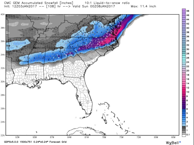
CMC Hits on friday evening...
-
Hello, please take a minute to check out our awesome content, contributed by the wonderful members of our community. We hope you'll add your own thoughts and opinions by making a free account!
You are using an out of date browser. It may not display this or other websites correctly.
You should upgrade or use an alternative browser.
You should upgrade or use an alternative browser.
Supershow said:Canadian says a little more North

Sent from my iPhone using Tapatalk

That could be right, but I think it's Temps are off. Should be further south
T
Thundersnow89
Guest
Thank you Canada!!
richardjacks
Meteorologist
Given the "flat" look on the sw until it reaches the GOM, I expect it will trend northward a bit. Got to love the look of the moisture already spreading into Texas well before the sw arrives...precip amounts prob. underdone a bit.
Nam0806
Member
Ghicks said:Looks like nw nc is gonna miss this one
Too early to say that. However, would like to see the proverbial northwest trend start for our areas in the next 24 hours.
accu35
Member
I agree Chris, temps should be cold enough to support snow further south.Deltadog03 said:Supershow said:Canadian says a little more North
Sent from my iPhone using Tapatalk
That could be right, but I think it's Temps are off. Should be further south
Storm5
Member
cmc is faster vs the gfs. whatever happens it's gonna be a fast moving system. remember last week when the euro was giving us a 36 hour overrunning event .......
Sent from my SM-G900V using Tapatalk
Sent from my SM-G900V using Tapatalk
I am in Birmingham currently, and have lived in North Georgia also. I would say that we are due for a more southerly track, it has not happened in a while from what I remember over the past few years...
whatalife
Moderator
Deltadog03 said:Supershow said:Canadian says a little more North
Sent from my iPhone using Tapatalk
That could be right, but I think it's Temps are off. Should be further south
I agree. I like the track and the temps appear to be off...
Sent from my iPhone using Tapatalk
If it's gonna be fast then it must be some heavy snow
Storm5 said:cmc is faster vs the gfs. whatever happens it's gonna be a fast moving system. remember last week when the euro was giving us a 36 hour overrunning event .......
Sent from my SM-G900V using Tapatalk
Yea I hope it comes through during the day Saturday. Friday night and we will miss it.
Webberweather53
Meteorologist
Here's what I'm talking about. That ULL over great lakes starts to dig considerably further southwestward than the previous run and phases with this once it gets to GA. Although this run may miss wide right (GFS progressive bias may be partially to blame) it highlights the fact there's definitely a risk of a huge coastal Miller A bomb off the Carolinas and VA... If we see the same trend with this feature that we observed with the first northern stream disturbance that's going to shear this out a little over the Pacific northwest and northern Rockies in the next day or so (w/ NS disturbance trending deeper, further SW), could get mighty interesting to say the least in the Carolinas & Mid-Atlantic

GaWx said:Jackpot of 3-6": central MS to Montgomery to ATL (more in southern areas like Tony's), Athens, Columbus, Macon, Augusta, Columbia, Florence, Myrtle, ILM. Even El Kabong in Perry, GA scores a big one.
Thanks for the shout-out, Larry! I would love to see that scenario play out down this way, but I'm not sure if the suppressed track will hold. Sounds like Chris is still expecting the inevitable NW shift which would likely leave us with rain and 33! Would love to hear your thoughts for the central GA area.
B
Brick Tamland
Guest
Canadian looks good for here.

accu35
Member
Storm5 said:cmc is faster vs the gfs. whatever happens it's gonna be a fast moving system. remember last week when the euro was giving us a 36 hour overrunning event .......
Sent from my SM-G900V using Tapatalk
Agreed, overrunning was showing 36 hrs GFS about 12-15 hrs, I'll still take those hrs lol
This 12Z GFS track would be an unusually far south track in the GOM and crossing central FL but far from unheard of. Examples: 2/25/1914, 2/9-10/1973, and 1/2-3/2002, all of which gave MCN sig wintry wx including their top two snowfalls on record and gave a lot of wintry wx to many areas of the deep south. Atlanta got a good snow from 2/1914 and 1/2002 but missed 2/1973. With a central FL crossing, ATL sometimes gets hit nicely and sometimes is too far north.
Storm5
Member
not me I want it overnight to maximize cooling. it will be there in the am when you wake up.FLO said:Storm5 said:cmc is faster vs the gfs. whatever happens it's gonna be a fast moving system. remember last week when the euro was giving us a 36 hour overrunning event .......
Sent from my SM-G900V using Tapatalk
Yea I hope it comes through during the day Saturday. Friday night and we will miss it.
but who the hell would sleep with a wite storm ongoing outside. not me, I'll sleep Sunday when we shoot into the mid 30s
Sent from my SM-G900V using Tapatalk
Well. Canadian is a swing and miss for CAE. We do see some Wintry weather, but its mainly to our North.
Canadian phases the second northern stream influx with our shortwave
Yeah CMC starts to bomb off GA coastWebberweather53 said:Here's what I'm talking about. That ULL over great lakes starts to dig considerably further southwestward than the previous run and phases with this once it gets to GA. Although this run may miss wide right (GFS progressive bias may be partially to blame) it highlights the fact there's definitely a risk of a huge coastal Miller A bomb off the Carolinas and VA... If we see the same trend with this feature that we observed with the first northern stream disturbance that's going to shear this out a little over the Pacific northwest and northern Rockies in the next day or so (w/ NS disturbance trending deeper, further SW), could get mighty interesting to say the least in the Carolinas & Mid-Atlantic
Sent from my SM-S820L using Tapatalk
B
Brick Tamland
Guest
UK looks like a good hit here, too.
This will probably happen screwing CAE as usual.Brick Tamland said:Canadian looks good for here.
That's more like it! GFS is pulling a clown on us againBrick Tamland said:Canadian looks good for here.
whatalife
Moderator
Shawn said:Well. Canadian is a swing and miss for CAE. We do see some Wintry weather, but its mainly to our North.
Temps are off IMO
Sent from my iPhone using Tapatalk
H
HartselleWeather
Guest
Brick Tamland said:Canadian looks good for here.
Also on the north side of the precip it will be a higher snow ratio considering the cold attic air.
whatalife said:Shawn said:Well. Canadian is a swing and miss for CAE. We do see some Wintry weather, but its mainly to our North.
Temps are off IMO
Sent from my iPhone using Tapatalk
I closed it when it didn't show a big hit as I thought it would for us. I'd figure the low is too close/too much warm air advection over our way.
Also, if this starts to phase sooner, wouldn't that put alot more people in play?tellicowx said:Yeah CMC starts to bomb off GA coastWebberweather53 said:Here's what I'm talking about. That ULL over great lakes starts to dig considerably further southwestward than the previous run and phases with this once it gets to GA. Although this run may miss wide right (GFS progressive bias may be partially to blame) it highlights the fact there's definitely a risk of a huge coastal Miller A bomb off the Carolinas and VA... If we see the same trend with this feature that we observed with the first northern stream disturbance that's going to shear this out a little over the Pacific northwest and northern Rockies in the next day or so (w/ NS disturbance trending deeper, further SW), could get mighty interesting to say the least in the Carolinas & Mid-Atlantic
Sent from my SM-S820L using Tapatalk
Sent from my SM-S820L using Tapatalk
accu35
Member
Can't wait for gefs
I'm using a blend of the GFS model for the tempswhatalife said:Shawn said:Well. Canadian is a swing and miss for CAE. We do see some Wintry weather, but its mainly to our North.
Temps are off IMO
Sent from my iPhone using Tapatalk
whatalife
Moderator
Shawn said:whatalife said:Shawn said:Well. Canadian is a swing and miss for CAE. We do see some Wintry weather, but its mainly to our North.
Temps are off IMO
Sent from my iPhone using Tapatalk
I closed it when it didn't show a big hit as I thought it would for us. I'd figure the low is too close/too much warm air advection over our way.
I think it's in a good spot for the most part
Sent from my iPhone using Tapatalk
Storm5
Member
I mean why are we worrying about temps off an unreliable model 3-4 days out . it's kinda obvious the gfs is on its own at the model . Eric brought up a good point about the gfs being too progressive.
God I need some tequila . gonna be along 4 days
better get the wife some wine incase we are snowed in
Sent from my SM-G900V using Tapatalk
God I need some tequila . gonna be along 4 days
better get the wife some wine incase we are snowed in

Sent from my SM-G900V using Tapatalk
dsaur
Member
Bham 99 said:I am in Birmingham currently, and have lived in North Georgia also. I would say that we are due for a more southerly track, it has not happened in a while from what I remember over the past few years...
Agreed. Since I've been south of Atl, after living in Atl until the early 80's, I've seen deeper snow than I ever saw in Atl. Sometimes things line up right and we are closer to the heavy rains near the furnace, but not so close as to be warm nosed to death. Atl gets it more often, but I get deeper amounts when I get a good path thru here. T
whatalife
Moderator
Storm5 said:I mean why are we worrying about temps off an unreliable model 3-4 days out . it's kinda obvious the gfs is on its own at the model . Eric brought up a good point about the gfs being too progressive.
God I need some tequila . gonna be along 4 days
better get the wife some wine incase we are snowed in
Sent from my SM-G900V using Tapatalk
LOL! Nice. You've gone from loaning your wife out to buying her a bottle of wine. HAHA!
Sent from my iPhone using Tapatalk
H
HartselleWeather
Guest
What the the ukmet say about the storm?
Webberweather53
Meteorologist
tellicowx said:Also, if this starts to phase sooner, wouldn't that put alot more people in play?tellicowx said:Yeah CMC starts to bomb off GA coastWebberweather53 said:Here's what I'm talking about. That ULL over great lakes starts to dig considerably further southwestward than the previous run and phases with this once it gets to GA. Although this run may miss wide right (GFS progressive bias may be partially to blame) it highlights the fact there's definitely a risk of a huge coastal Miller A bomb off the Carolinas and VA... If we see the same trend with this feature that we observed with the first northern stream disturbance that's going to shear this out a little over the Pacific northwest and northern Rockies in the next day or so (w/ NS disturbance trending deeper, further SW), could get mighty interesting to say the least in the Carolinas & Mid-Atlantic
Sent from my SM-S820L using Tapatalk
Sent from my SM-S820L using Tapatalk
Yea it would, but that would most likely be the Apps and Mid-Atlantic and mixing would be an issue along/south of I-20, but it definitely would up the ante for areas of the Carolinas & VA, perhaps northeastern GA... The track/intensity being advertised by the UKMET atm is ideal for the I-85 corridor from ATL-GSP-CLT-GSO-RDU-RIC
Shawn said:Well. Canadian is a swing and miss for CAE. We do see some Wintry weather, but its mainly to our North.
I honestly don't buy that. It's the warmest model of them all. I would think Temps should support snow or wintry precip down our way.
Storm5
Member
held serve looks like previous runs. would get a similar cmc solutionHartselleWeather said:What the the ukmet say about the storm?
Sent from my SM-G900V using Tapatalk
Claycochaser
Member
Well, lookie here...found you guys! In the nick of time it appears.