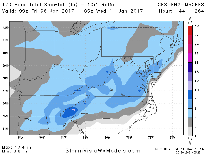
Storm5 link said:There are some MASSIVE gefs members on the 00z run
Sent from my SM-G900V using Tapatalk
What service are you getting those members from so fast? I am on WXBell and still stuck at day 5 - 1/2 on my end :/
Storm5 link said:There are some MASSIVE gefs members on the 00z run
Sent from my SM-G900V using Tapatalk
Shawn link said:[quote author=Storm5 link=topic=80.msg5240#msg5240 date=1483161309]
There are some MASSIVE gefs members on the 00z run
Sent from my SM-G900V using Tapatalk
Snowaddict28 link said:Us folks in Birmingham can't buy a snowstorm at least once... I'm sorry everyone I just want my kids to see snow this year
I know it can and probably will change a bunch between now and go time, but it's not a great run for those of us near I-20.Snow_Chaser link said:[quote author=olhausen link=topic=80.msg5221#msg5221 date=1483160186]
This has got to be one of the best runs ever board wide.
Sent from my iPad using Tapatalk
Storm5 link said:so there are hit, complete misses and cutters on the gefs
Sent from my SM-G900V using Tapatalk
Bsudweather link said:Usually when there's a big storm models will lose it and show something crazy only to bring it back. And most of time but not all time when they come back, we end up with a storm. Were starting to get into that window where things are getting serious now. Just a few days ago the GFS was showing pretty much this same setup with enormous totals. Then it lost it, and now its back with the enormous totals again. I would not be surprised at all now to see other models start following suite to this.
Bsudweather link said:Usually when there's a big storm models will lose it and show something crazy only to bring it back. And most of time but not all time when they come back, we end up with a storm. Were starting to get into that window where things are getting serious now. Just a few days ago the GFS was showing pretty much this same setup with enormous totals. Then it lost it, and now its back with the enormous totals again. I would not be surprised at all now to see other models start following suite to this.
Shawn link said:[quote author=Storm5 link=topic=80.msg5240#msg5240 date=1483161309]
There are some MASSIVE gefs members on the 00z run
Sent from my SM-G900V using Tapatalk
The GFS showed something similar before Christmas on one of it's runs and then lost it of course. Seems that sometimes the GFS goes back to what it originally showed week(s) later. The more models come on board with this setup and if they stay that way, we'll be looking at a major winter storm in the coming days.Bsudweather link said:Usually when there's a big storm models will lose it and show something crazy only to bring it back. And most of time but not all time when they come back, we end up with a storm. Were starting to get into that window where things are getting serious now. Just a few days ago the GFS was showing pretty much this same setup with enormous totals. Then it lost it, and now its back with the enormous totals again. I would not be surprised at all now to see other models start following suite to this.
So, so, close! Dang it! :'(Stormlover link said:GFS give me at Huntsville a Thunderstorm and 34 next Sat night at 6PM...good grief
192 01/08 00Z 34 34 57 5 0.54 0.05 544 558 3.4 -20.4 1018.1 100 -TSRA 021OVC088 112BKN198 228SCT300 34 33 0.0

Gulf lows and Gulf coastal lows can produce some strong instability.Stormlover link said:GFS give me at Huntsville a Thunderstorm and 34 next Sat night at 6PM...good grief
192 01/08 00Z 34 34 57 5 0.54 0.05 544 558 3.4 -20.4 1018.1 100 -TSRA 021OVC088 112BKN198 228SCT300 34 33 0.0
The GFS showed something similar before Christmas on one of it's runs and then lost it of course. Seems that sometimes the GFS goes back to what it originally showed week(s) later. The more models come on board with this setup and if they stay that way, we'll be looking at a major winter storm in the coming days.NorthGAWinterWx link said:[quote author=Bsudweather link=topic=80.msg5252#msg5252 date=1483161676]
Usually when there's a big storm models will lose it and show something crazy only to bring it back. And most of time but not all time when they come back, we end up with a storm. Were starting to get into that window where things are getting serious now. Just a few days ago the GFS was showing pretty much this same setup with enormous totals. Then it lost it, and now its back with the enormous totals again. I would not be surprised at all now to see other models start following suite to this.


Shawn link said:Crap map, no inbetween that show much.. but here is tonight's UKMET (notice the low off the NC coast not nearly as strong as GFS OP one would guess with it):
The GFS showed something similar before Christmas on one of it's runs and then lost it of course. Seems that sometimes the GFS goes back to what it originally showed week(s) later. The more models come on board with this setup and if they stay that way, we'll be looking at a major winter storm in the coming days.Cary_Snow95 link said:[quote author=NorthGAWinterWx link=topic=80.msg5263#msg5263 date=1483162297]
[quote author=Bsudweather link=topic=80.msg5252#msg5252 date=1483161676]
Usually when there's a big storm models will lose it and show something crazy only to bring it back. And most of time but not all time when they come back, we end up with a storm. Were starting to get into that window where things are getting serious now. Just a few days ago the GFS was showing pretty much this same setup with enormous totals. Then it lost it, and now its back with the enormous totals again. I would not be surprised at all now to see other models start following suite to this.
Gulf lows and Gulf coastal lows can produce some strong instability.NorthGAWinterWx link said:[quote author=Stormlover link=topic=80.msg5261#msg5261 date=1483162212]
GFS give me at Huntsville a Thunderstorm and 34 next Sat night at 6PM...good grief
192 01/08 00Z 34 34 57 5 0.54 0.05 544 558 3.4 -20.4 1018.1 100 -TSRA 021OVC088 112BKN198 228SCT300 34 33 0.0
bouncycorn link said:[quote author=Shawn link=topic=80.msg5265#msg5265 date=1483162409]
Crap map, no inbetween that show much.. but here is tonight's UKMET (notice the low off the NC coast not nearly as strong as GFS OP one would guess with it):
6 inches of snow for North GA ? I'm sure a lot of that is ice.Brick Tamland link said:That's a mean looking mean.
I'd be surprised if anything survived that look. Looks cold and northern stream dominateShawn link said:Crap map, no inbetween that show much.. but here is tonight's UKMET (notice the low off the NC coast not nearly as strong as GFS OP one would guess with it):
Bsudweather link said:Usually when there's a big storm models will lose it and show something crazy only to bring it back. And most of time but not all time when they come back, we end up with a storm. Were starting to get into that window where things are getting serious now. Just a few days ago the GFS was showing pretty much this same setup with enormous totals. Then it lost it, and now its back with the enormous totals again. I would not be surprised at all now to see other models start following suite to this.
The GFS showed something similar before Christmas on one of it's runs and then lost it of course. Seems that sometimes the GFS goes back to what it originally showed week(s) later. The more models come on board with this setup and if they stay that way, we'll be looking at a major winter storm in the coming days.bouncycorn link said:[quote author=Cary_Snow95 link=topic=80.msg5267#msg5267 date=1483162510]
[quote author=NorthGAWinterWx link=topic=80.msg5263#msg5263 date=1483162297]
[quote author=Bsudweather link=topic=80.msg5252#msg5252 date=1483161676]
Usually when there's a big storm models will lose it and show something crazy only to bring it back. And most of time but not all time when they come back, we end up with a storm. Were starting to get into that window where things are getting serious now. Just a few days ago the GFS was showing pretty much this same setup with enormous totals. Then it lost it, and now its back with the enormous totals again. I would not be surprised at all now to see other models start following suite to this.
The GFS showed something similar before Christmas on one of it's runs and then lost it of course. Seems that sometimes the GFS goes back to what it originally showed week(s) later. The more models come on board with this setup and if they stay that way, we'll be looking at a major winter storm in the coming days.NorthGAWinterWx link said:[quote author=bouncycorn link=topic=80.msg5271#msg5271 date=1483162584]
[quote author=Cary_Snow95 link=topic=80.msg5267#msg5267 date=1483162510]
[quote author=NorthGAWinterWx link=topic=80.msg5263#msg5263 date=1483162297]
[quote author=Bsudweather link=topic=80.msg5252#msg5252 date=1483161676]
Usually when there's a big storm models will lose it and show something crazy only to bring it back. And most of time but not all time when they come back, we end up with a storm. Were starting to get into that window where things are getting serious now. Just a few days ago the GFS was showing pretty much this same setup with enormous totals. Then it lost it, and now its back with the enormous totals again. I would not be surprised at all now to see other models start following suite to this.
Brick Tamland link said:Complete misses to a couple of bigood hits.

