• Hello, please take a minute to check out our awesome content, contributed by the wonderful members of our community. We hope you'll add your own thoughts and opinions by making a free account!

Wintry 1/7/17-1/10/17 Winter Storm

Stormlover link said:
IN case this hasn't been posted:
610temp.new.gif

Those maps are created differently on weekdays vs weekends....weekdays have human input while weekend are model generated. I expect them to get worse soon.
 
12z para heads the wrong direction as well. pretty good model agreement from the 12z set

Sent from my SM-G900V using Tapatalk
 
Storm5 link said:
12z para heads the wrong direction as well. pretty good model agreement from the 12z set

Sent from my SM-G900V using Tapatalk
Nice to see model agreement at this range!
 
Storm5 link said:
12z para heads the wrong direction as well. pretty good model agreement from the 12z set

Sent from my SM-G900V using Tapatalk

Son of a nutcracker!
 
Storm5 link said:
12z para heads the wrong direction as well. pretty good model agreement from the 12z set

Sent from my SM-G900V using Tapatalk
yeah. i think were in trouble
 
On a positive note, it can't get much worse, if your only expecting rain, then only happy surprises and happy trees!
 
modelwatcher link said:
Even if we do not score with wintry precip next weekend, the 12Z EURO has highs next Sunday at or below 32F for a lot of us. Looking very cold as of now.

IMG_0211_zpsldpuxyf6.png

Although it looks very cold as of now, I'd take those very cold modeled temperatures with a huge grain as even the Euro has been cold biased of late. Just its prior run had similarly very cold for next Saturday with 1 PM readings near 32. The 12Z run has about 40 at 1 PM. Of course, the details of operational runs out past a week should always be taken with a grain. But i'd take modeled very cold even more with a grain due to a significant cold bias as of late.
 
Stormlover link said:
IN case this hasn't been posted:
610temp.new.gif

That seems completely different from what I've seen on the GFS (that's one model though). From what I saw there it's above average here outside of a few days and that update puts me at slight above.
 
From looks of things, likely won't be good news on the 18z GFS.  Modeling just getting to the time-period though.
 
Not sure where it's going but a tad colder and juicer
 
hoping that west end slows a bit and the high dropping in helps push it south.

edit: maybe a little more separation. lets see where it goes I spose'
 
JLL1973 link said:
[quote author=Usmeagle2005 link=topic=80.msg5026#msg5026 date=1483135014]
I had a feeling, I told my wife about it..... kids of death in my area. ? In Tupelo, Ms
you guys usually get more than we do
[/quote]are you serious? wow....not this stuff again. I'd take where Corinth is in a heartbeat. Same junk every winter. Why would a place a few miles south of you usually get more? smh
 
Para has a low around Columbus maybe? That's not that bad of a run
 
notice that little pv lobe pushing further to the east faster vs 12
 
Lock this thread and let's get the mojo going back in the January discussion
 
NorthGaWinter link said:
Lock this thread and let's get the mojo going back in the January discussion

might can get something secondary.
 
Please don't let brick ever start a thread again. This turnaround in this short of time has been remarkable.
 
NorthGaWinter link said:
Lock this thread and let's get the mojo going back in the January discussion
I think we shouldn't just take two runs and jump the cliff. We should wait until tomorrow's 18Z, and if things keep getting worse, and trending NW, then we can all jump.
 
Counting this system and the New Years system most of the drought areas will be getting a lot of rain.


Sent from my iPhone using Tapatalk
 
the icy/mix is filling into ms/al. snow in tn  1031 traveling overhead. with the secondary wave.
 
ForsythSnow link said:
[quote author=NorthGaWinter link=topic=80.msg5046#msg5046 date=1483136429]
Lock this thread and let's get the mojo going back in the January discussion
I think we shouldn't just take two runs and jump the cliff. We should wait until tomorrow's 18Z, and if things keep getting worse, and trending NW, then we can all jump.
[/quote]

Euro, gfs, gefs, eps and the CMC all suck.
 
low pops around southern sc/savannah ga or so.  parts of tn not too shabby snow wise. some mix/ice/snow on the tail end as the cold air pushing down.
 
this was a slight step to a better result with the second wave.  i'd check out the ensembles with this in a bit.  al/ms/tn look a bit more Wintry this go around.

edit: also the whole second deal is slower vs 12

snow trying to make it into N. central/N. eastern NC.  not horrible.
 
Stormlover link said:
[quote author=NorthGaWinter link=topic=80.msg5057#msg5057 date=1483136840]
1/7-1/10 drought buster thread. Change the name
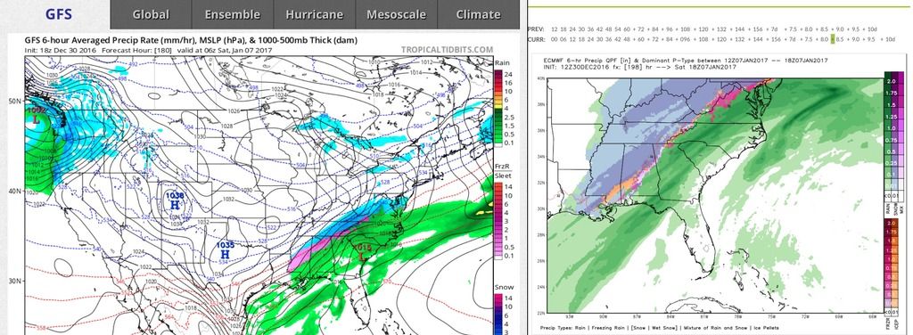
man, take a break....get away from it for a while..seriously.
[/quote]

Not saying starting this thread started it... but it went downhill fast when we did. Hope 00z runs are better
 
Actually, the GFS and EURO are not too far off on the chances of some back end winter precip for some parts of the SE with the second wave...

IMG_0212_zps5halbhbg.jpeg
 
Shawn link said:
this was a slight step to a better result with the second wave.  i'd check out the ensembles with this in a bit.  al/ms/tn look a bit more Wintry this go around.

edit: also the whole second deal is slower vs 12

snow trying to make it into N. central/N. eastern NC.  not horrible.

Yep, SER flexing its muscle though, only hope is that the models are overestimating the SER
 
modelwatcher link said:
Actually, the GFS and EURO are not too far off on the chances of some back end winter precip for some parts of the SE with the second wave...

If we can get it a bit slower and a little further south with that system behind the first, we might all be a bit more wintry than we think.
 
18z GFS shows me there is plenty of time to improve which I'm fine with that. Indications shows between Euro and GFS there may be secondary low we could have
 
Back
Top