Webberweather53
Meteorologist
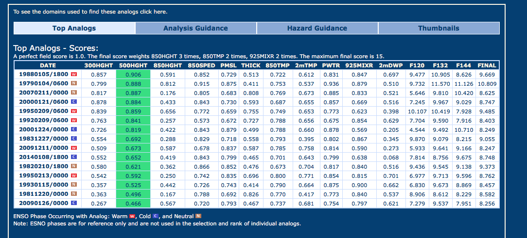
#1 medium range CIPS analog is January 1988, lmao
That makes no sense to me. It's showing 12 near Atlanta then 21 east of Atlanta and 24 west of Atlanta and 18 north of Atlanta. According to that map, Atlanta will be the coldest place in the entire southeast. And it can't be because of snowpack because it would be mostly ice in Atlanta with more snow north of Atlanta.SoutheastRidge link said:[quote author=ForsythSnow link=topic=80.msg6351#msg6351 date=1483310020]
Brrrr Atlanta area.

I think Larry can back me up on this, you don't want a " bomb" low in the gulf! Too much waa, and could even be convections robbing moisture influx! Only need, want a 1003-1014 mb,lowNorthGAWinterWx link said:Checked surface water temps in the northern Gulf. Waters are warm, temps are in the 70s...some stations reporting close to 80. There will be some high QPF levels with this low.
Sent from my SM-J700T1 using Tapatalk
I think Larry can back me up on this, you don't want a " bomb" low in the gulf! Too much waa, and could even be convections robbing moisture influx! Only need, want a 1003-1014 mb,lowTarheel1 link said:[quote author=NorthGAWinterWx link=topic=80.msg6371#msg6371 date=1483311259]
Checked surface water temps in the northern Gulf. Waters are warm, temps are in the 70s...some stations reporting close to 80. There will be some high QPF levels with this low.
Sent from my SM-J700T1 using Tapatalk
The GFS had something like this before over the weekend or it was this past Fri. I think it was. This 18z GFS run is an huge improvement. Also, the 18z GFS agreed with 12z CMC and 12z Euro.MiddleTNWx link said:That run just made me very happy. Too bad it is the 18z run though. Lol beggers can't be choosers, so I will take it!
NorthGAWinterWx link said:There we go folks, we have model agreement.
Sent from my SM-J700T1 using Tapatalk
DadOfJax link said:[quote author=NorthGAWinterWx link=topic=80.msg6347#msg6347 date=1483309691]
There we go folks, we have model agreement.
Sent from my SM-J700T1 using Tapatalk
NorthGAWinterWx link said:[quote author=DadOfJax link=topic=80.msg6387#msg6387 date=1483311781]
[quote author=NorthGAWinterWx link=topic=80.msg6347#msg6347 date=1483309691]
There we go folks, we have model agreement.
Sent from my SM-J700T1 using Tapatalk
")
Wrong storm system. Shows some other system though that gives some snow.bouncycorn link said:NAVGEM has a major cutter though lol
Tarheel1 link said:[quote author=NorthGAWinterWx link=topic=80.msg6389#msg6389 date=1483311871]
[quote author=DadOfJax link=topic=80.msg6387#msg6387 date=1483311781]
[quote author=NorthGAWinterWx link=topic=80.msg6347#msg6347 date=1483309691]
There we go folks, we have model agreement.
Sent from my SM-J700T1 using Tapatalk
I was going to agree with you Larry. That would be a huge hit here of ZR. My guess is it would be even colder than modeled but let's not get ahead of ourselves. LolGaWx link said:Per the 18Z GFS, this would be the biggest sleetstorm for the city of ATL and south metro ATL since the great 1988 4" mainly sleetstorm..even bigger than 2/2014 for most except maybe the northern burbs. It appears that this major sleet would get down to Tony in south metro ATL and even further south per 850's being colder than +3 C. Macon would likely get a major ZR out of this as modeled. Of course, this is just per what the model shows, not a prediction.
That screams massive ice storm for me and you ShawnShawn link said:Not wanting any kind of "bomb" until crossing over Florida. Already bad enough as it is modeled from 18z for us down here. Waiting until Florida cross to rapidly strengthen will help everyone involved in the Carolinas.
I think Larry can back me up on this, you don't want a " bomb" low in the gulf! Too much waa, and could even be convections robbing moisture influx! Only need, want a 1003-1014 mb,lowTarheel1 link said:[quote author=NorthGAWinterWx link=topic=80.msg6371#msg6371 date=1483311259]
Checked surface water temps in the northern Gulf. Waters are warm, temps are in the 70s...some stations reporting close to 80. There will be some high QPF levels with this low.
Sent from my SM-J700T1 using Tapatalk
Is the 18z run usually not a reliable run ? Should we toss it ?MiddleTNWx link said:That run just made me very happy. Too bad it is the 18z run though. Lol beggers can't be choosers, so I will take it!
Is the 18z run usually not a reliable run ? Should we toss it ?SoutheastRidge link said:[quote author=MiddleTNWx link=topic=80.msg6374#msg6374 date=1483311361]
That run just made me very happy. Too bad it is the 18z run though. Lol beggers can't be choosers, so I will take it!
I think Larry can back me up on this, you don't want a " bomb" low in the gulf! Too much waa, and could even be convections robbing moisture influx! Only need, want a 1003-1014 mb,lowTarheel1 link said:[quote author=NorthGAWinterWx link=topic=80.msg6371#msg6371 date=1483311259]
Checked surface water temps in the northern Gulf. Waters are warm, temps are in the 70s...some stations reporting close to 80. There will be some high QPF levels with this low.
Sent from my SM-J700T1 using Tapatalk
I think Larry can back me up on this, you don't want a " bomb" low in the gulf! Too much waa, and could even be convections robbing moisture influx! Only need, want a 1003-1014 mb,lowGaWx link said:[quote author=Tarheel1 link=topic=80.msg6379#msg6379 date=1483311572]
[quote author=NorthGAWinterWx link=topic=80.msg6371#msg6371 date=1483311259]
Checked surface water temps in the northern Gulf. Waters are warm, temps are in the 70s...some stations reporting close to 80. There will be some high QPF levels with this low.
Sent from my SM-J700T1 using Tapatalk
That screams massive ice storm for me and you ShawnDeltadog03 link said:[quote author=Shawn link=topic=80.msg6385#msg6385 date=1483311675]
Not wanting any kind of "bomb" until crossing over Florida. Already bad enough as it is modeled from 18z for us down here. Waiting until Florida cross to rapidly strengthen will help everyone involved in the Carolinas.
Is the 18z run usually not a reliable run ? Should we toss it ?SoutheastRidge link said:[quote author=MiddleTNWx link=topic=80.msg6374#msg6374 date=1483311361]
That run just made me very happy. Too bad it is the 18z run though. Lol beggers can't be choosers, so I will take it!
I think Larry can back me up on this, you don't want a " bomb" low in the gulf! Too much waa, and could even be convections robbing moisture influx! Only need, want a 1003-1014 mb,lowTarheel1 link said:[quote author=NorthGAWinterWx link=topic=80.msg6371#msg6371 date=1483311259]
Checked surface water temps in the northern Gulf. Waters are warm, temps are in the 70s...some stations reporting close to 80. There will be some high QPF levels with this low.
Sent from my SM-J700T1 using Tapatalk

