RollTide18
Member
This is why I'm not completely giving up on this, crazy as it sounds. Wouldn't hurt to keep a watch on it.

Yeah, I think this thread should be closed. If there was going to be a winter storm during this time, it would have been on the models by now on every single model run. The time frame is now in the 5 day window, so there probably won't be any major changes.Time to close the books on the one in here guys. The real threat will be the 29th - 30th storm.
Any objections ?

Good trend. But stil doesn’t get the job done.
View attachment 12744

Slightly better with less PV press.

Sent from my iPhone using Tapatalk

Yep and just a frame later is another big improvement. We actually get a phase this run it’s just too late.
View attachment 12754
Need a stronger southern wave.
Yep and we could handle it being a bit more north too. Our wave won’t be onshore for another 2 days. So this could change a lot still.
But I’m doubtful.
Yeah more like along the gulf coast.
Sent from my iPhone using Tapatalk

I agree please don't turn this forum into the mess the other one has. I love this forum as everyone is allowed to be who they are within reason.Why would we close a thread? If one needs to be closed its the whining thread.
Now we have created numerous posts discussing closing a thread which is banter. If you don't think there is going to be a storm don't open the thread and read it. Its simple really
Sent from my SM-G955U using Tapatalk


This is honestly not far off from how the December 2010 storm went down.
Models didn’t catch on until the day of.
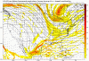
Here is two days out:
View attachment 12763
Here is day of:
View attachment 12764
Also here is a snippet from the event summary:
“This solution would eventually verify fairly well and was close to the ECMWF forecast 6 to 7 days out.”
The fv3 7 days out repeatedly gave many a good snow for this current storm.
You can read the summary here.
https://projects.ncsu.edu/atmos_collaboration/nwsfo/storage/cases/20101226/
Of course this current storm may not come north like the 2010 storm did. BUT we have a very similar setup to 2010. Models in the 7 day range gave many areas a snow storm. But have since suppressed it.
We have had a decent trend to speed up the southern wave over the last 5 fv3 runs and the 06z phases it and delievers a powerful storm up north.
This could very easily be another case of models overly suppressing a storm