Snowflowxxl
Member
Baby step improvement. Nice to see overall.


Don’t do it Kylo. 2nd system or bust
Depends on how involved the northern stream is. That 06z FV3 run amped up pretty good and was cold all the way to the coast.
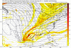
View attachment 12390


This thing really still has a chance. The players are all on the field and the potential I not yet dead. Everyone needs to just hold on and let it play out. The only storm I ever saw that don’t waffle all over the place on a hit was Jan 2010. That sucker locked in on all models 5-6 days out. Ever other winner followed a script similar to this so don’t giv up yet.
Seeing a very interesting trend on the FV3. The small shortwave over Texas before the one we are watching is trending slower each run. If our shortwave and that one phase it could change things down the road.


FV3 went BOOM!


Sent from my iPhone using Tapatalk
Certainly another good test for itI am telling y'all, if the FV3 has a storm, there is hope. It lead the way with the December storm and has been the most consistent one with this storm. It seems to be locking on this one and not letting go.

Seems to me that while the surface maps are way different, the driving force does have a defined trend. Good catch.If this trend continues, a quicker phase/NW trend is imminent. Everyone except those in SC/NC should run with the FV3 with all they have. Dare say I give some props to the 12z CMC?
It’s going to be what I’ve thought since yesterday. Columbia to the coast and eastern Nc. Georgia and upstate sc and nc mountains this isn’t our storm
Sent from my iPhone using Tapatalk
Please put these types of personal pronouncements in the banter thread.It’s going to be what I’ve thought since yesterday. Columbia to the coast and eastern Nc. Georgia and upstate sc and nc mountains this isn’t our storm
Sent from my iPhone using Tapatalk
Please put these types of personal pronouncements in the banter thread.

Rain mainlyHow could this impact us in SC?