packfan98
Moderator
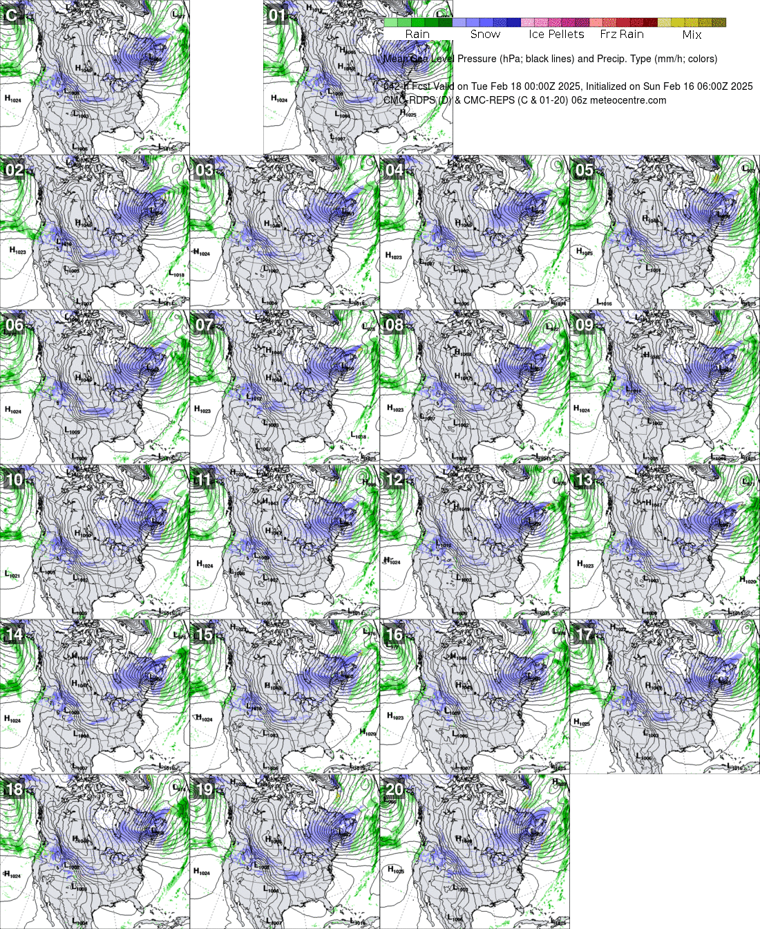
RGEM looks better at the surface. Slight NW shift on the precip shield.

The RGEM is the only hope for the Midlands of SC and the CSRA to see snow tomorrrow. Hope it's correct.
Lol… that’s basically back to the same look that was showing yesterday morning before the wheels fell off. Verbatim, that warning criteria snowfall for CLT metro east of 77 and 85 then up along and to the east of I-85 with advisory level west back into the foothills.
The RGEM has also shown a similar solution the last two runs.Lol… that’s basically back to the same look that was showing yesterday morning before the wheels fell off. Verbatim, that warning criteria snowfall for CLT metro east of 77 and 85 then up along and to the east of I-85 with advisory level west back into the foothills.
Honestly, I'd have to see a few more runs to think that will happen. Still skeptical we get that much in the Triangle but confidence is increasing and things certainly looking better.One thing I hadn't noticed is the past 4 runs the snow has backed west. CLT is right on the hip of 3-4".
It did about as well as the HRRR over the weekend in picking up the strong FGEN forcing that set up. Hopefully it’s leading the way hereThis may be me being a weenie. But maybe the RDPS detects the Northwest part of the storm better precip wise.
Sent from my iPhone using Tapatalk
Lol… that’s basically back to the same look that was showing yesterday morning before the wheels fell off. Verbatim, that warning criteria snowfall for CLT metro east of 77 and 85 then up along and to the east of I-85 with advisory level west back into the foothills.
Yeah, it's so tricky. If the system is robust enough and the precip is there, the NW cutoff will be brutal, especially if it involves the big cities along the I-85 corridor. Looks like every 15 miles there's a difference of half an inch. I'm sure there will be 15-30 mile shifts in the next cycles of model suites. It's interesting at least.The RGEM has also shown a similar solution the last two runs.

I remember someone yesterday showed what is considered the model that those in house models are coming from and it was continuing to show a lot of precip well back to the west then as well even while every other model was drastically cutting back moisture. What struck me odd about it is that those models tend to have a very noticeable dry bias to them… remember in January 2014 how ATL area mets were using them on screen to downplay the snow threat from that storm even though every other model was beginning to put down a couple inches of snow with temperatures in the low 20sThe mets around here are showing in house models that have snow pretty far back west even to the SC/GA border so it does make it interesting with these considerable shifts to the west.
RGEM would be about 15 hours of snow. That's hard to believe, but it is within the realm of possibility. I would liked to have seen amounts tick up, but they're almost the same and still pretty far on the high end of the rest of the guidance.Personally, I favor a broader precip shield back to the west like the RDPS is showing, with a good storm in Raleigh. Would be nice to get the Columbia area some snow...awfully tough down there
With more forcing and FGEN it definitely does make sense to see the precip shield quite a bit further west.Personally, I favor a broader precip shield back to the west like the RDPS is showing, with a good storm in Raleigh. Would be nice to get the Columbia area some snow...awfully tough down there
Seems to have snow from 10am tomorrow thru 3am Saturday in the Triangle. (i think). That's impressive.RGEM would be about 15 hours of snow. That's hard to believe, but it is within the realm of possibility. I would liked to have seen amounts tick up, but they're almost the same and still pretty far on the high end of the rest of the guidance.
A lot of people disregard the ICON but for this storm thus far it has probably been the most consistent and steady of all the models.
The ICON was the first model to start shift back west yesterday on the 18z runs. I stand by what I said then… if it’s the model to start the trend that works to give me a decent snow, I will take back all the bad things I said and never bad mouth it again… lolA lot of people disregard the ICON but for this storm thus far it has probably been the most consistent and steady of all the models.
With the back and forth that some of the other models have shown it would be a coup if it would verify with this system.


Looking good for Columbia. Looks like freezing rain for Aiken and Augusta however. Need more west shift to put the CSRA more in the snow zone. It might finally be happening everyone!Looking better for the SC crowd and CLT it appears.


What’s funny is that Brad P just released a new video before the 12z models started coming in. He talked about how much dryer things had trended. This of course after he did the some thing yesterday. He might want to start waiting to do his video till after the model runsTalk to me. Tell me something.
View attachment 108733


