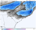
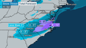
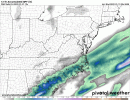
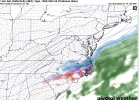
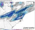
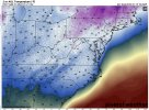
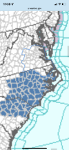
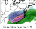
No doubt this is trending towards an eastern NC storm for snow. Ice looks to be a MAJOR issue in SE NC and NE SC. They aren't used to this kind of weather so it may turn into quite the spectacle. There's still time for a NW shift but I'm not holding my breath.
-
Hello, please take a minute to check out our awesome content, contributed by the wonderful members of our community. We hope you'll add your own thoughts and opinions by making a free account!
You are using an out of date browser. It may not display this or other websites correctly.
You should upgrade or use an alternative browser.
You should upgrade or use an alternative browser.
Wintry 1/20 - 1/23 Winter Storm
- Thread starter packfan98
- Start date
NBAcentel
Member
iGRXY
Member
Yeah it's drying up for those further east now too.
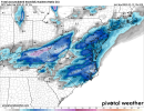
Yep. NE South Carolina and SE North Carolina(including even all the way down as far south as Whiteville and Wilmington) gets 1-2 inches of snow if the GFS is correct, along with sleet. Also a widespread 3-6 inches of snow from the US 70 corrdior areas and points north in North Carolina. As much as I hate seeing seeing less and less precip for Central SC, a more suppressed solution like this would be good news far as avoiding a major ice storm for all areas.good news with these trends is if you're in the pee dee region in sc more snow than ice now. gfs continues the east trend with the 06z and 12z suite.
Last edited:
There is still a lot of time for the NW trend machine to go brrr. If you’re in the triangle, you can look at this suppressed trend with dismay or you can look at it as an insurance policy. If I go back to old storm threads, I can show you a litany of 3km snowfall maps that light up the triangle for storms that treated Roxboro very kindly.
- Joined
- Jan 23, 2021
- Messages
- 4,602
- Reaction score
- 15,197
- Location
- Lebanon Township, Durham County NC
I am offended by your use of logic, sir. Even as bad as this run "looks", it still puts down nearly half a foot over a large section of Wake County.There is still a lot of time for the NW trend machine to go brrr. If you’re in the triangle, you can look at this suppressed trend with dismay or you can look at it as an insurance policy. If I go back to old storm threads, I can show you a litany of 3km snowfall maps that light up the triangle for storms that treated Roxboro very kindly.
L
Logan Is An Idiot 02
Guest
Brad p also agrees with that
Sent from my iPhone using Tapatalk
Dewpoint Dan
Member
1-3" of snow in Athens ? What model is showing that ?
Yeah I think that makes sense and you normally see that bit of ramp up with this type of system in the last 24 hours. The extent though is sensitive to the 500mb setup of courseEven with what we’ve seen the last few hours, it still looks to me like there should be a more expansive precip shield to the north and west. Maybe not warning criteria stuff, but maybe some advisory level. Do you think so?
-------- calling for 4-6" from Troy NC and points NE, essentially.
I read another Met I respect out of the mtn thread on amwx. Ward doesnt seem phased a bit, references back to how the same spectacle unfolded Dec 2017. Says 6zgfs had a snow sounding in Asheville, but nothing painted on the surface mapNo doubt this is trending towards an eastern NC storm for snow. Ice looks to be a MAJOR issue in SE NC and NE SC. They aren't used to this kind of weather so it may turn into quite the spectacle. There's still time for a NW shift but I'm not holding my breath.
snowlover91
Member
Interesting the NAVGEM of all models has been trending stronger and more amped.


- Joined
- Jan 23, 2021
- Messages
- 4,602
- Reaction score
- 15,197
- Location
- Lebanon Township, Durham County NC
Did he do a live or is it an image?-------- calling for 4-6" from Troy NC and points NE, essentially.
Did he do a live or is it an image?
blueheronNC
Member
Can’t remember the last time a Winter Storm Watch (or warning) verified for Raleigh, unless it gets issued in real time with warning-level criteria being experienced. WSW is the Heisman Trophy of products - kiss of death.
Yeah I felt that way about a lot of the runs coming in. Totals were cut but… still an above average event for a lot of folks. 6 inches of pixie dust in Raleigh would satisfy its yearly average. It’s hard to get that much snow here! Felt like a funeral procession on the forums watching these runs come in. Yeah obs you don’t want to be on the wrong side of the trend I get it but this isn’t a death sentence.I am offended by your use of logic, sir. Even as bad as this run "looks", it still puts down nearly half a foot over a large section of Wake County.
Did he do a live or is it an image?
- Joined
- Jan 23, 2021
- Messages
- 4,602
- Reaction score
- 15,197
- Location
- Lebanon Township, Durham County NC
Agreed. As you know, not every storm is created equally as well. With 4-6”(which would be what I expect N-S across the triangle) falling in to the antecedent conditions that we have, you’re going to have a much higher impact event.Yeah I felt that way about a lot of the runs coming in. Totals were cut but… still an above average event for a lot of folks. 6 inches of pixie dust in Raleigh would satisfy its yearly average. It’s hard to get that much snow here! Felt like a funeral procession on the forums watching these runs come in. Yeah obs you don’t want to be on the wrong side of the trend I get it but this isn’t a death sentence.
Premature to say this is drying up/E NC/ SE VA storm when we are still 2-3 days out. Guidance can and will change, we never hit the dead zone with this one between days 3 and 5, something to keep an eye on. I do still like the two wave long duration scenario.
GEFS still lesser amounts but looked better than the Op overall


- Joined
- Jan 23, 2021
- Messages
- 4,602
- Reaction score
- 15,197
- Location
- Lebanon Township, Durham County NC
and people really need to watch tomorrow. Usually, in a scenario such as it is, we're waiting for the cold air to struggle over the hills. In this instance, it could slam through like a carolina norther.Premature to say this is drying up/E NC/ SE VA storm when we are still 2-3 days out. Guidance can and will change, we never hit the dead zone with this one between days 3 and 5, something to keep an eye on. I do still like the two wave long duration scenario.
Looking at the GEFS, the threat isn't dead, yet. In fact... some members are pretty nutty, even involving most of GA still.
And looking at the 12z NBM still a solid frozen precip footprint for NC up into SE VA


Cary_Snow95
Member
Rip. Cmc way east. Barely gets precip into wake
yeah some are amped, some are suppressed, you see amounts on some that get back to N GA, this one ain't over yet that's for sureLooking at the GEFS, the threat isn't dead, yet. In fact... some members are pretty nutty, even involving most of GA still.

Downeastnc
Member
Premature to say this is drying up/E NC/ SE VA storm when we are still 2-3 days out. Guidance can and will change, we never hit the dead zone with this one between days 3 and 5, something to keep an eye on. I do still like the two wave long duration scenario.
I mean we got this one kind of right where we want it IMO, trending weaker and east just means when the inevitable amping happens its far enough east to jackpot us Raleigh east folks for once....
I’m confused with Brad p video. He said main reason is rain or snow. Did not mention qpf reduction over the past few days or the sleet factor. Yikes ?. Anywho, I like where the winter storm watch is placed there could be advisories for Charlotte and some special weather statements for Wilkes/Surry for this event up to light snow accums.I hope more
Last edited:
packfan98
Moderator
Canadian follows the trends of the day.


Ok at the risk of being a weenie, I’m gonna bring up the 2010 Christmas storm. That week on the 23rd, models started trended way east that morning and by the evening everyone on weather boards was putting a nail in the coffin on that storm. I remember though Brad P and Matthew East, along with a few other mets including Joe Bastardi, dug in and said the storm would still happen. Then we all watched the next day as the models started trending back west again throughout the day. I’m not saying that happens here, but living in the Carolinas for over 40 years tells me that even with what we’ve seen this morning, there should be a bigger footprint of snowfall back in the western area than what is currently being depicted
FamouslyHot
Member
Local Mets still seem fairly optimistic. NWS CAE has this in their latest discussion:Looking at the GEFS, the threat isn't dead, yet. In fact... some members are pretty nutty, even involving most of GA still.
"However, it appears as if the entire cwa will be
impacted by some sort of wintry weather Friday evening through
Friday night before the precip begins moving out Saturday
morning. Can not rule out the need to expand the Winter Storm
Watch if qpf amounts trend higher. Additional Advisory products
will more than likely be required closer to the event. "
The model trends to the east are disheartening for snow lovers in the Northeast Piedmont but I think that at this time the NWS forecast for two to five inches of snow is still very reasonable. The EURO runs again in about a couple of hours and we'll have to see if it is picking up on what the NAM and other models are. It would be a gut punch to lose out on what was once a very promising storm at the very last minute.
brendan123
Member
Snowflowxxl
Member
The GEFS were horrible last weekend
Local Mets still seem fairly optimistic. NWS CAE has this in their latest discussion:
"However, it appears as if the entire cwa will be
impacted by some sort of wintry weather Friday evening through
Friday night before the precip begins moving out Saturday
morning. Can not rule out the need to expand the Winter Storm
Watch if qpf amounts trend higher. Additional Advisory products
will more than likely be required closer to the event. "
I believe that was written before today's 12z guidance. GEFS ensembles cause me great pause and I'm paying attention to it.
1” widespread snow should be a win ? for those near or west of i77. It better than 0”. It’s certainly feasible we get some advisory level snows near Davie County down to Concord (0.5”-2”). Time to stop being negative as we approach the event, I was just trying not to overhype this back on Saturday of last week. Advisory criteria is different for Wilkes/Surry so I would go with special weather statement 0.5”-2”.
snowlover91
Member
UK running, let's see if it continues the weaker/east trend.

