iGRXY
Member
Comparing 00z NAM and previous runs definitely improves due to orientation and seemingly more moisture so future runs may squeeze some more out... But yeah all of Westward always pulling for the phaseThere is no moisture to work with there. N AL needs it to phase about 200 - 300 miles west of there.


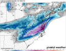
And both continuing to still snow at their end points .. amazing really .. what were temps like on RGEM?00z NAM vs RGEM Kuchera. Insane resemblance.


Sent from my iPhone using Tapatalk
Would be awesome for us. Remember that, despite this past storm, the Upstate is long past due for a good year. Once very common, GSP has not recorded more than 10 inches in a season since 1992-1993; looong time! Even though there were some good patterns in years like 02-03, 09-10, 10-11, and 13-14, most of the upstate seemed to find ways to skip, min, or mix its way to mediocre and minor events. Virtually everybody else along the I 85 corridor from N Atl to CLT, to RDU and even Greenville NC has fared way better. Maybe this will be our year.If the NAM is proven to be correct WOW, just WOW. GSP would obviously break some records with this being their 2nd 6-inch+ snowfall in less than a week. CLT-RDU would finally break their snow drought. I mean, this is just weather porn. Just wish we could be a little less amped so that way this won't strictly be a climo storm. Would love to guarantee folks a good 50 miles south of 85 wouldn't be another sleet fest.
Look up in the threadAnyone have the 0z RGEM
RDPS = RGEMAnyone have the 0z RGEM
That’s the 18zIt's still going here in Carolinas
View attachment 108115
Just not our storm. NAM is warmer across AL when the precip is around and everything else is too far east.The RGEM and NAM are still not close here. One has a biblical ice storm and the other is a light dusting
Yea my badThat’s the 18z
And both continuing to still snow at their end points .. amazing really .. what were temps like on RGEM?
Precip wise, I would hang in there if I were in central/north MS/AL/GA. Many have commented on it, but models do tend to miss on the NW side if we get something closer to the NAM/RDPS especially. This is from the EPS Ens Mean - shows a strengthening subtropical jet stream with the right front region of the jet propagating across the south (right, front region = upper level divergence, helps with lift for precip)Nam Keeps expanding the NW precip shield
Sent from my iPhone using Tapatalk

With most storms associated with the subtropical jet stream, they tend To be further NW/be more juicedPrecip wise, I would hang in there if I were in central/north MS/AL/GA. Many have commented on it, but models do tend to miss on the NW side if we get something closer to the NAM/RDPS especially. This is from the EPS Ens Mean - shows a strengthening subtropical jet stream with the right front region of the jet propagating across the south (right, front region = upper level divergence, helps with lift for precip)
There will be many more runs of the NAM so we'll have to see where it slides. Doubt it will stay exactly where it is.the gradient over wake county on the NAM is just so unsettling, it's making me nauseous and my eye is twitching, pretty sure the #1 programmer of that godforsaken model is albert hitchcock
And kicking out the SW wave to the east a touch more out to hr51GFS looks like it’s continuing the trend of having the N/S further west