Cary_Snow95
Member
Almost the exact same footprint of snow as the ICON
Almost the exact same footprint of snow as the ICON
I was thinking the same. Euro, GFS, RGEM, ICON, UKMET all show a heavy band from ne of Charlotte towards se VirginiaWhy do I feel like the models are really "reeling" a solution in now. Small tweaks likely but there seems to be a consensus on where the zones are setting up.
I agree completely… every one talks about the January ‘88 storm and how dry and powdery the snow was, even it was a 12:1 ratio in CLT. To me the only time we ever truly see high ratio snow pan out is when we get strong enough clipper type system that able to redevelop precip east of the mountains… the January ‘03 storm for example that had 40:1 ratios in CLT.Perhaps, though I’m always nervous to predict above 10:1 ratios around our region. It hardly ever happens, even when the conditions look promising.


That’s really close towards the gulf coast also
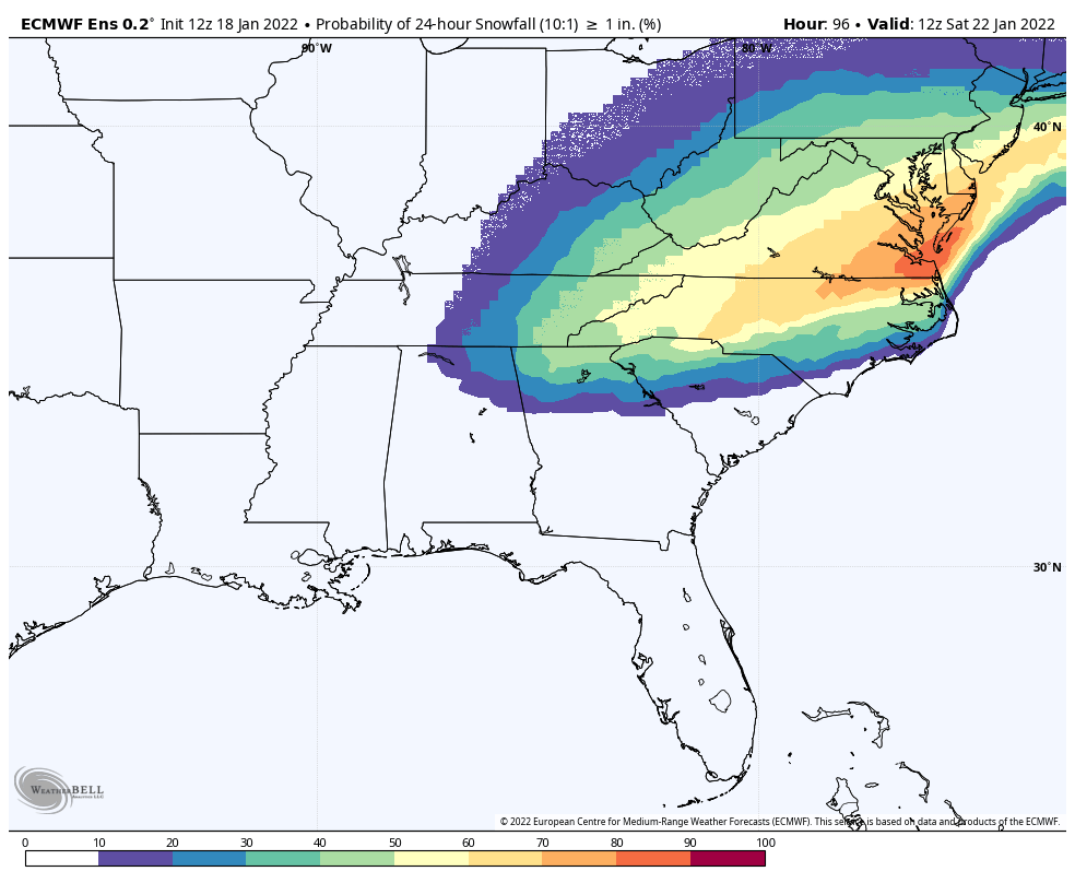
And that’s on a 10:1 ratio. I think we’re gonna do at least 13:1 if not 15:1.
Do you mind posting the 12z total snowfall mean for comparison?
 GEFS members
Looks slightly better then last run in NC espView attachment 107975GEFS members
Looks slightly better then last run in NC esp

CAD is also much deeper into SC.View attachment 107975GEFS members


More NC centric/not as NWDo you mind posting the 12z total snowfall mean for comparison?


Our energy in question is actually on shore now as we speakWhen will the energy actually be on shore and fully sampled?
I think the separation part is fine, but where we normally see that is with a southern stream overrunning setup where the wave tracks out of TX/OK into TN, but the sfc low goes Miller A because the airmass is so cold out front with damming (Jan 88). The GFS scenario doing the same concept but with a northern stream wave...yeah, I don't know of any examples of that. The northern stream 500mb vort max tracks from S Indiana to E PA on the GFS. The end result is indeed beautiful in central-east areas. It will be interesting to see the direction we go. The NAM / RDPS / GFS are going about it in different ways.I can't recall an event where the upper low was so far removed from the surface low and produced that kind of precip. Can you?


It is good to see that many will get a storm in some form or fashion, especially the Triangle folks. What are your thoughts for which way this is heading?I think the separation part is fine, but where we normally see that is with a southern stream overrunning setup where the wave tracks out of TX/OK into TN, but the sfc low goes Miller A because the airmass is so cold out front with damming (Jan 88). The GFS scenario doing the same concept but with a northern stream wave...yeah, I don't know of any examples of that. The 500mb vort max tracks from S Indiana to E PA on the GFS. The end result is indeed beautiful in central-east areas. It will be interesting to see the direction we go. The NAM / RDPS / GFS are going about it in different ways.
GFS does have a nice sharpening of 850mb warm advection in central-east Carolinas here for precip generation
What's seemingly nice is each of the models you named get us there but in different ways. Nice to now there's a couple ways to get the job doneI think the separation part is fine, but where we normally see that is with a southern stream overrunning setup where the wave tracks out of TX/OK into TN, but the sfc low goes Miller A because the airmass is so cold out front with damming (Jan 88). The GFS scenario doing the same concept but with a northern stream wave...yeah, I don't know of any examples of that. The 500mb vort max tracks from S Indiana to E PA on the GFS. The end result is indeed beautiful in central-east areas. It will be interesting to see the direction we go. The NAM / RDPS / GFS are going about it in different ways.
GFS does have a nice sharpening of 850mb warm advection in central-east Carolinas here for precip generation
What does the frame before look like?18z CMC looks much better !! View attachment 107985
Really hard to say, but I agree with you on the various solutions all still producing a winter storm. Biggest takeaway for me is keeping the north solutions into the Mid-Atlantic out of the equation. That's been the biggest plus today, and we have a few more days to keep it that way. Of course, that is not the direction you want to go if you are on the NW side of thingsIt is good to see that many will get a storm in some form or fashion, especially the Triangle folks. What are your thoughts for which way this is heading?
That’s one thing I noticed was the FGEN. I would expect QPF to only increase with such a look.I think the separation part is fine, but where we normally see that is with a southern stream overrunning setup where the wave tracks out of TX/OK into TN, but the sfc low goes Miller A because the airmass is so cold out front with damming (Jan 88). The GFS scenario doing the same concept but with a northern stream wave...yeah, I don't know of any examples of that. The northern stream 500mb vort max tracks from S Indiana to E PA on the GFS. The end result is indeed beautiful in central-east areas. It will be interesting to see the direction we go. The NAM / RDPS / GFS are going about it in different ways.
GFS does have a nice sharpening of 850mb warm advection in central-east Carolinas here for precip generation
.jpg")

Thru 7pm fridayRAH starting to increase totals.
View attachment 107996


