icon very similar to the cmc and nam and euro.

-
Hello, please take a minute to check out our awesome content, contributed by the wonderful members of our community. We hope you'll add your own thoughts and opinions by making a free account!
You are using an out of date browser. It may not display this or other websites correctly.
You should upgrade or use an alternative browser.
You should upgrade or use an alternative browser.
Wintry 1/20 - 1/23 Winter Storm
- Thread starter packfan98
- Start date
Chattownsnow
Member
I want to believe but it seems to me ensemble support is waning for our general area. Typically I would look at this and be licking my chops at this stage of modeling. However things appear to be trending more towards our east at this time. Carolina’s gonna get smashed again it appears. If Nooga somehow escapes this whole pattern unscathed I’ll be disappointed, but not surprised lol
Iceagewhereartthou
Member
It's a precarious dance. I definitely want to see the QPF come about 100 miles further west to get the upstate and N GA in on this one, but I don't want it to to skip areas further south who are due at the same time. A blend of last nights Euro and UKMET would be good for a lot folks.Yep NW Trend is evident, just how far NW it goes is still a guess. There gonna be a lot more people in the game for snow time this one is done. Even NE Ga gonna see some snow
Sent from my SM-A526U using Tapatalk
- Joined
- Jan 23, 2021
- Messages
- 4,604
- Reaction score
- 15,203
- Location
- Lebanon Township, Durham County NC
If I was along a line from Columbia all the way to Myrtle Beach, I'd be prepping for a hellacious ice storm and pray that sleet or plain rain saves the day.
Cary_Snow95
Member
 Icon going for it
This is a warm "tongue" "finger", whatever you want to call it at the surface, it's not the warm nose that often gets discussed (that is in the mid levels) just don't want to confuse anyone, especially the newest of members still trying to learn.GA 400 warm nose, anyone? Worth noting that there's still a snow sounding here @ 33.74, -84.31View attachment 107771
One liners, imby constant questions, low effort post are going to get deleted especially as traffic picks up. Please as has been requested numerous times utilize the whamby/banter thread for that stuff.
Last edited:
this westward shift sure seems familiar - we keep doing it every single storm lol

Philconnors
Member
This almost reminds me of the 1/28/14 storm. Models showed exactly what this is showing precip shield ended up well north into very cold/dry air as we all remember. The setup looks similar at face value. Snow started over south alabama and expanded north.
Even so, the 850 line is much further south from a stronger cold push. It looks more like the Ukmet!12z RDPS is less amped with the wave compared to 06z run

Since I just moved to live on the beach near Morehead City, NC (Emerald Isle to be specific), I'm not used to following weather directly on the coast. How does the ocean affect precip types in a more micro environment? If you're, say, 15 miles inland, does that give you better chance to see frozen precip vs living on the beach? What's the thoughts on getting frozen precip directly on the coast in SE NC? Thanks for any input!
- Joined
- Jan 5, 2017
- Messages
- 3,807
- Reaction score
- 6,063
The NAM had a pretty stout warm layer around 850mb at the 84 hour time stamp, at least in my area.This is a warm "tongue" "finger", whatever you want to call it at the surface, it's not the warm nose that often gets discussed (that is in the mid levels) just don't want to confuse anyone, especially the newest of members still trying to learn.
Attachments
Last night's UKMet was Nirvana....cleared the front thru, then slight delay, then phases the waves well to the SE. Cold and snowyIt's a precarious dance. I definitely want to see the QPF come about 100 miles further west to get the upstate and N GA in on this one, but I don't want it to to skip areas further south who are due at the same time. A blend of last nights Euro and UKMET would be good for a lot folks.

Huge run for areas to the south!Even so, the 850 line is much further south from a stronger cold push. It looks more like the Ukmet!
View attachment 107780

L
Logan Is An Idiot 02
Guest
We are starting to get a general footprint, from the upstate-sw Piedmont thru central NC and NE NCView attachment 107775
That’s 10:1 ratio as well. Totals would be even higher! Big storm in the making for ENC
Sent from my iPhone using Tapatalk
I have to be driving into Jacksonville from home in LA, arriving Friday. If current trends keep up, I may have to cut to the coast at Myrtle Beach and hug the coast all the way to Jacksonville. I guess it would be best to drive up as far as I can on Thursday, in case things deteriorate badly.If I was along a line from Columbia all the way to Myrtle Beach, I'd be prepping for a hellacious ice storm and pray that sleet or plain rain saves the day.
iGRXY
Member
Expect the SW to likely phase sooner as the trend has been quicker phases . You can already starting to see more digging on the models so the GFS is about to be real telling.
I'm really liking the shift to a colder press over the NE. That would put a lot more people in the game for snow.this westward shift sure seems familiar - we keep doing it every single storm lol
View attachment 107779
That run would be good for singificant snow for the Midlands of SC and the CSRA area. Also a nice sleet event for areas futher south as well. We all need to hope for a stronger cold push with 850s crashing like Rgem model is showing. Maybe a damanging ice storm could be avoided for most areas with that sort of look.Even so, the 850 line is much further south from a stronger cold push.
As long as that WAR can keep trending weaker, this might be the winner that us in the southeast parts of CLT metro have been overdue for.We are starting to get a general footprint, from the upstate-sw Piedmont thru central NC and NE NCView attachment 107775
NBAcentel
Member
Really liking the upstate thru the SW Piedmont (85 from gsp thru clt) for overrunning/FGEN generated stuff, and eastern central - NE NC/SE VA for coastal stuff With current looks, this isn’t just a flat out Miller A/hybrid given inverted trough in AL/TN. it begins initially as overrunning for areas west as well
Tarheelwx
Member
I thought a Miller B would always have an initial low that would transfer to a new developing low. This almost always results in CAD. I thought a Miller A had no hand off of one low to another. I didn’t think p-types had anything to do with whether it was a Miller A or B. For instance, couldn’t you have a Miller A in May that was rain only - or for that matter a Miller B with all rain? In sum, doesn’t miller A or Miller B have to do with atmospheric pressures and development, and nothing to do with p-types? Obviously, mixed Ptypes are more synonymous with Miller B’s and less so with Miller A’s. Thanks. TWYeah, the NAM is Miller A. You can still get a lot of mixed precip types in a Miller A with CAD, depending on the setup. Miller B is a surface low tracking into N Bama / E TN (or NW of there), then reforming along the coast. Miller A / Miller B is very surface low track centric
iGRXY
Member
That's the 12z. The 0Z is the time period at 84 hoursThat’s 0z lol
No, it isn't. You're looking at the valid time, not Init.That’s 0z lol
first call subject to change fkls we are close to the event now is the time to issue these.Purple)6-12”+ snow, Red)3-6” snow/sleet mix, Blue)1-2”snow ice mix south, Yeller) 0-1” snow with ice SC south, a lot rides on lack of qpf could change 25-50miles west or east but really no major surprises instore thank you credit me if you want to copy my forecast (using blend of gfs,German,icon and dryer solutions) haven’t budged past 4 days I’m not changing by the run!
Hypsometric
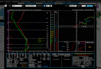
Member
Raleigh sounding at 84 on the RGEM.

This one is near Clinton, east of I-95 in Sampson County.

This one is near Clinton, east of I-95 in Sampson County.
Lets hope that we can trend towards a weaker WAR from this point forward. Based on history,I think that's quite unlikely,but who knows. If the Regm Model is right with the cold push,this would help many areas escape from a major ice storm and would help to put many more areas futher south in the snow zone.As long as that WAR can keep trending weaker, this might be the winner that us in the southeast parts of CLT metro have been overdue for.
Yeah, that would really match that look of the January 2002 storm that was posted earlier. Pretty classic look for the CarolinasReally liking the upstate thru the SW Piedmont (85 from gsp thru clt) for overrunning/FGEN generated stuff, and eastern central - NE NC/SE VA for coastal stuff With current looks, this isn’t just a flat out Miller A, it begins initially as overrunning for areas west
LukeBarrette
im north of 90% of people on here so yeah
Meteorology Student
Member
2024 Supporter
2017-2023 Supporter
First call 3-4 days out with lots of uncertainity in models is uncalled for. The UKMET bias is strong with this map. Just saying.....first call subject to change fkls we are close to the event now is the time to issue these.Purple)6-12”+ snow, Red)3-6” snow/sleet mix, Blue)1-2”snow ice mix south, Yeller) 0-1” snow with ice SC south, a lot rides on lack of qpf could change 25-50miles west or east but really no major surprises instore thank you credit me if you want to copy my forecast (using blend of gfs,German,icon and dryer solutions) haven’t budged past 4 days I’m not changing by the run!View attachment 107783
brad is live now. saying primarily snow/sleet for clt as of now. 1-2" per the ensembles.

 www.facebook.com
Brad Panovich Meteorologist
------------- Meteorologist, Charlotte. 449,702 likes · 45,414 talking about this. Chief Meteorologist at WCNC-TV Weather Geek Extraordinaire!
www.facebook.com
NBAcentel
Member
That’s what webb told me as well for the CLT areabrad is live now. saying primarily snow/sleet for clt as of now.
Brad Panovich Meteorologist
------------- Meteorologist, Charlotte. 449,702 likes · 45,414 talking about this. Chief Meteorologist at WCNC-TV Weather Geek Extraordinaire!
Hypsometric
Member

Wow that’s something for Brad… he almost always starts out mentioning ice for CLTbrad is live now. saying primarily snow/sleet for clt as of now.
Brad Panovich Meteorologist
------------- Meteorologist, Charlotte. 449,702 likes · 45,414 talking about this. Chief Meteorologist at WCNC-TV Weather Geek Extraordinaire!
I am across the sound from you. The ocean has a moderating influence on our weather and the effect of the ocean lessens as you head farther inland. In this case, the warmer ocean waters will keep us warm enough to keep us mainly rain. However, areas farther inland (west of Highway 17) will be cooler which will allow for more impacts from snow, sleet, and freezing rain. For us to get snow, the low needs to move well offshore to allow colder air to be pulled in from areas to our northwest. So in order for us to get a decent storm, areas farther west will usually receive little to no precip which the majority of this board would not like.Since I just moved to live on the beach near Morehead City, NC (Emerald Isle to be specific), I'm not used to following weather directly on the coast. How does the ocean affect precip types in a more micro environment? If you're, say, 15 miles inland, does that give you better chance to see frozen precip vs living on the beach? What's the thoughts on getting frozen precip directly on the coast in SE NC? Thanks for any input!
Iceagewhereartthou
Member
I would have a hard time putting any stock in the NAM; it performed very poorly in this last storm, especially the 12k.
iGRXY
Member
WAA with colder 850's and CAD definitely screams more FGEN. I really think 85 from NE Georgia through CLT is in a sweet spot as we will start getting the coastal moisture as well. But definitely Eastern NC looks great right now too.Really liking the upstate thru the SW Piedmont (85 from gsp thru clt) for overrunning/FGEN generated stuff, and eastern central - NE NC/SE VA for coastal stuff With current looks
Need another jet streak somewhere near eastern FL
")
Cad Wedge NC
Member
Yeah. But the 3K did very well.I would have a hard time putting any stock in the NAM; it performed very poorly in this last storm, especially the 12k.
That's because there were issues with p-types due to its lower resolution. It really wasn't that far off on a synoptic level.I would have a hard time putting any stock in the NAM; it performed very poorly in this last storm, especially the 12k.
Howdy neighbor! My parents live on the sound right behind the Speedway station as soon as you come on the island, so you may be able to see their boat dock ha! I live on the island right near the EI/Indian Beach line. I really appreciate your input. I hate that we will likely see all rain. I was out west for this past event and had my flight canceled to EWN Sunday due to the storm over the weekend, so I missed that too haha! Maybe we can luck out with this one some how. Where are you in reference to the bridge coming onto the island?I am across the sound from you. The ocean has a moderating influence on our weather and the effect of the ocean lessens as you head farther inland. In this case, the warmer ocean waters will keep us warm enough to keep us mainly rain. However, areas farther inland (west of Highway 17) will be cooler which will allow for more impacts from snow, sleet, and freezing rain. For us to get snow, the low needs to move well offshore to allow colder air to be pulled in from areas to our northwest. So in order for us to get a decent storm, areas farther west will usually receive little to no precip which the majority of this board would not like.