Interestingly enough, this run doesn't depict a full phase. It took a big step in that direction but didn't fully phase. A full phase would put areas further NW more in play, including those in GA.
-
Hello, please take a minute to check out our awesome content, contributed by the wonderful members of our community. We hope you'll add your own thoughts and opinions by making a free account!
You are using an out of date browser. It may not display this or other websites correctly.
You should upgrade or use an alternative browser.
You should upgrade or use an alternative browser.
Wintry 1/20 - 1/23 Winter Storm
- Thread starter packfan98
- Start date
Stephenb888
Member
I know this has potential, but there’s still ALOT of questions. Which makes me curious as to why Chris Justus is already honking the horn on this one with so much time left. I’m guessing just piggybacking off of the most recent storm to keep ratings high?
A Cuba low is what we want 96+ hrs out with the trailing wave, back to basics…
NBAcentel
Member
Gefs looks far better 
Interestingly enough, this run doesn't depict a full phase. It took a big step in that direction but didn't fully phase. A full phase would put areas further NW more in play, including those in GA.
6z should be get the job done. Massive change from 18z to 12z. Euro leading the way with this one. Would be nice to see a compromise to get place like RDU in the snow this time though
Sent from my iPhone using Tapatalk
Note the WAR or absence of it on gfs run
It’s coming and will up until go timeNote the WAR or absence of it on gfs run

I'm not so sure it's caving to the euro. NAM isn't setting up quite like the euro. Let's see the CMC6z should be get the job done. Massive change from 18z to 12z. Euro leading the way with this one. Would be nice to see a compromise to get place like RDU in the snow this time though
Sent from my iPhone using Tapatalk
Snownut
Member
I think by time this one is done the Whole upstate gets the Snow with this one. I know this sounds like wishcasting, but you can bet this things is pulling NW!
Sent from my SM-A526U using Tapatalk
Sent from my SM-A526U using Tapatalk

brendan123
Member
H5 looks much worse on the GEFS than the past 3 runs (At least in terms of where the 540 line is set up in NC)

Lots of good members NW
NBAcentel
Member


Whatever WAA or what not is coming .. it don’t matter .. a big winter storm is about to go down for many in the SE
accu35
Member
You got a map further west?
mydoortotheworld
Member
Am I having dejavú? It feels like we went back in time to the 12z Jan 15th runs
NBAcentel
Member

Where you gotta hope that the GFS is locked in and other models trend toward it but, yeah that’s a long shot.
GeorgiaGirl
Member
Am I having dejavú? It feels like we went back in time to the 12z Jan 15th runs
It was the 18z from the 15th.
This may be the case, with the only difference being the WAR being stronger, so there's more mixing issues.
The thing that's too bad is that the GEFS is likely wrong, as that's a solid run.
accu35
Member
And that not including ice too
yeah your right. Down here....meh....next...lolTBH this run looks a lot like the euro.. pretty sizable adjustment.
NBAcentel
Member

0z GFS Op through 120 - Kuchera
.png")
Cary_Snow95
Member
Weaker war. Is this real life? Other than that changes mostly seem to be speed
brendan123
Member
The low on the CMC sets up in the same exact position Saturday morning as the 12Z run but is considerably deeper
Cary_Snow95
Member

GFS looking better but I would shift 50miles East and that’s prob our outcome. Snow chances around Raleigh east
NBAcentel
Member
beautiful 
Cary_Snow95
Member
CMC has been rock solid

GeorgiaGirl
Member
Thoughts?
brendan123
Member
Interesting to see that the CMC has the biggest snow set up in the same area as the ICON, GFS, GEFS, and EPS (before the EPS' shift north towards Central VA on the 18z run...)
Stephenb888
Member
Eh I think this has a chance to be juicy for NE Ga, upstate sc, and east.GFS looking better but I would shift 50miles East and that’s prob our outcome. Snow chances around Raleigh east
Arguably one of the most beautiful things I've ever seenbeautiful View attachment 107649

RDU goes from 27 degree snow at the start to 25 degree snow in the thick of it to 23 degrees at the end … high ratio snow with arctic air moving through afterword verbatim .. and this is being show under 100 hours now .. still the gradient could easily move SE or NW but you’re not going to move that surface cold air for manybeautiful View attachment 107649
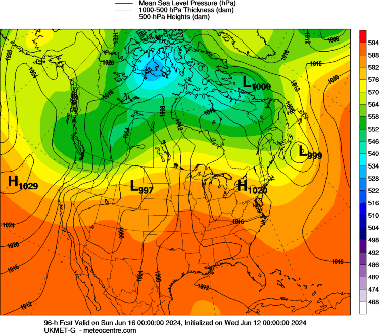
Snowflowxxl
Member
Holy $hit the UKMET!!!!!!!
With how the precip comes in I think the biggest snow winner would be north/east NC into south-east Virginia. Raleigh still in game tho but better be careful on any east trends I could see sharp west to east gradients in precip shield