brendan123
Member
I'm 90% sure that that algorithm counts anything frozen as snow. Wxbells maps look entirely different.
View attachment 107515

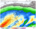
This was the mean at 12z and it had looked the same for the past few runs, SE Virginia can’t win
I'm 90% sure that that algorithm counts anything frozen as snow. Wxbells maps look entirely different.
View attachment 107515
Even with the control phasing and hitting the big cities, it keeps CLT in the mid-upper 20’s thru the stormYes/ with warm nose issues
You ought to see the phase off the control at h5 from 18z
Do post....Yes/ with warm nose issues
You ought to see the phase off the control at h5 from 18z
What I don’t like is there’s less 50/50 low/less confluence, this thing still has room to go more west, but at this point Charlotte looks to get another mixed bag, impactful winter storm, it begins in 78~ hours after all, the wiggle rooms for taking Charlotte out of this is shrinking just off time and improving modeling skill as we get closer. I don’t buy the GFS at all tho, as the 18z CMC looked to be even more ampedEven with the control phasing and hitting the big cities, it keeps CLT in the mid-upper 20’s thru the storm
Looks like the GFS is in trouble, but only time will tell
I don't know if the outcome of the control has ever actually happenedOne thing I do think the control would give us is a change back to snow at the end
Always thought we need hookups to happen at or past Mississippi River. We want the Low to close off past that point.Means in phasing scenarios are very helpful to inside 72hrs, this is largely a partial phase as I read it. Ideally the southern stream is leading through south central TX, with a northern stream parcel catching up in SE OK, late hookup, this is atypical by standard but still may work for areas south of the NC/VA boarder.
We do, my post was setting that stage, apologize for the confusion. Interaction starts ~ Ark-La-Tex, really dependent on how much energy can drop down in to the southern shortwave from the northern stream. Very close to constructive interference vs destructive, fine line and timing this go round / separation.Always thought we need hookups to happen at or past Mississippi River. We want the Low to close off past that point.
Usually if its sooner,they cut to far west for us
That's just QPF .... what are the temps during that time?If you believe the EPS it rains for days in Raleigh. We got that to look forward to this weekend. ?
View attachment 107546

Nope, wxmodels does tho, in fact I’m gonna sign up real quick on wxmodels to have both sitesCharlotte gets over two inches QPF that would probably be sleet! Doesn't weatherbell have precip type maps for separate EPS members?
Yes I’m becoming convinced that I’m gonna sleet my way to an above average snowfall total this winter… lol. In all seriousness this certainly does look to be a high impact event for the entire CLT metro area. One of the things that could really help drive this CAD to overperform even from as strong as it looks now is the additional snowpack to our north. Right now GSP has me at a low of 19 Friday night with precipitation, and while I think teens might be pushing it, 21-23 seems fairly reasonableWhat I don’t like is there’s less 50/50 low/less confluence, this thing still has room to go more west, but at this point Charlotte looks to get another mixed bag, impactful winter storm, it begins in 78~ hours after all, the wiggle rooms for taking Charlotte out of this is shrinking just off time and improving modeling skill as we get closer. I don’t buy the GFS at all tho, as the 18z CMC looked to be even more amped
At a 3:1 ratio, that’s over 6” of sleet!!!Charlotte gets over two inches QPF that would probably be sleet! Doesn't weatherbell have precip type maps for separate EPS members?
You got RDUs?EPS has mainly 20s thru the entire thing, yikea View attachment 107548


Why am I seeing a lot of legit ice storms .. good lord
This run was literally 2” of snow and a bunch of sleet in the lower 20sIm extremely confident in all frozen or nothing 85 corridor, Triad esp where I have mby goggles on.
like all of us, Im always looking, chasing for the all snow precip type storm. Give Fro credit. The War and the 50/50 confluence are possibke red flags for the midlayers. Which is where my battle seems to be shaping up at.
WAR looks more suppressed this run as the northern stream is quite a bit stronger.Well if there’s one thing the NAM
Just cleaned up it’s that shortwave that enters the pacific north west, note the western ridge is taller, I think our main focus now is trying to fix the northern stream energy that goes over the NE/SE Canada and strengthening it, to suppress the WAR