Goodness! That is a ton of freezing rain. Spells lights out for a lot of us. Let's hope this isn't the case.Look how cold this setup is already, at hour 111View attachment 107154View attachment 107155View attachment 107156
-
Hello, please take a minute to check out our awesome content, contributed by the wonderful members of our community. We hope you'll add your own thoughts and opinions by making a free account!
You are using an out of date browser. It may not display this or other websites correctly.
You should upgrade or use an alternative browser.
You should upgrade or use an alternative browser.
Wintry 1/20 - 1/23 Winter Storm
- Thread starter packfan98
- Start date

After today, there is no way that is ice.These ice totals are about to be….whew
Snowflowxxl
Member
It’s already far too NW for my likingNot yuck!
NBAcentel
Member
Given the big ass mfucken run to run changes we’ve seen from amped to ots to amped, I wouldn’t call this a NW trend or really worry about this look being far NW yet
Well at least it ends as some "light" snow in the cold dark with trees through houses and power pole beaver damns along the highway per 00z Euro!
Maybe we can act like it's thundersnow when we hear the transformers going boom boom
Maybe we can act like it's thundersnow when we hear the transformers going boom boom

Cary_Snow95
Member
My takeaway is it's crazy cold and there wants to be a stormGiven the big ass mfucken run to run changes we just saw, I wouldn’t call this a NW trend or really worry about this look being far NW yet
Hypsometric
Member
It's really crazy how similar this was to the UKMET - the northern stream just didn't quite dive in as much and it turned out to be a good deal warmer because the mid-level (H85) cold couldn't penetrate as far southeast. Very subtle changes made a big difference.Given the big ass mfucken run to run changes we’ve seen from amped to ots to amped, I wouldn’t call this a NW trend or really worry about this look being far NW yet

Fine line for who gets what based on exactly how 500mb unfolds, but 00z runs trended more toward us having a storm, and big potential remains given the cold air setup to the NW

NBAcentel
Member


BHS1975
Member
Given the big ass mfucken run to run changes we’ve seen from amped to ots to amped, I wouldn’t call this a NW trend or really worry about this look being far NW yet
Gonna go ahead and say it to get it over with. SW not sampled yet blah blah blah.
Sent from my iPhone using Tapatalk
This run verbatim isn't the final solution; I just hate to see it like this. I've seen hints even on the ensembles bringing that 850 0c further and further inland.  Surface temps definitely don't seem to be a problem this time around.
Surface temps definitely don't seem to be a problem this time around.Snowflowxxl
Member
Regardless still the biggest board wide woof woof we’ve seen in some time
Hopefully, the ENS will look better overall for us (region wise). Need that northern piece to help us out more. At least, it has a storm signal there, nonetheless.
BHS1975
Member
This run verbatim isn't the final solution; I just hate to see it like this. I've seen hints even on the ensembles bringing that 850 0c further and further inland.
500mb ain't quite cutting it though with the 558dm benchmark for decent cold still up north a ways.
Sent from my iPhone using Tapatalk
BHS1975
Member
Here we go with the amped up warm nose crap again. With that track, at least central NC, North and West should be snow. What happened to the cold air at 850?
Need more NS phasing.
Sent from my iPhone using Tapatalk
Does this setup look similar to what happened in the Lowcountry back in Dec. 2018? Or was the 50/50 low different in nature? I recall CHS, etc. got a nice snowfall. Plentiful cold air around too. It just didn't go far enough to the west, to help folks out back this way.This run verbatim isn't the final solution; I just hate to see it like this. I've seen hints even on the ensembles bringing that 850 0c further and further inland.
Cary_Snow95
Member
Euro just needed to amp the northern stream a bit more which it trended to that run compared to 12z
NBAcentel
Member
Damn another “when my grandpa was alive” CAD coming back from the old days ? 
You want the wave diving down to stay more positive tilt as it dives down to get it colder farther east....this time it got to neutral quicker, so more moisture inland, but warmer along the coast. Fine lineHere we go with the amped up warm nose crap again. With that track, at least central NC, North and West should be snow. What happened to the ample supply of cold air at 850?
Shaggy
Member
This one run will not be the final solution so no need to lose hope on all.snow right now. Keep watching the ensembles and the ops and be patient.
Everyone east of Raleigh needs to hope this doesn’t happen like that euro op run
Everyone east of Raleigh needs to hope this doesn’t happen like that euro op run
Cary_Snow95
Member
We just had the gfs, cmc, ukie show snow and the euro show temps in the low 20s. We are okay
NBAcentel
Member
cutoff 582dm ridge over Seattle during the event 
Euro sfc loop

Cary_Snow95
Member
Anyone got the snow/sleet/zr maps from WB
NBAcentel
Member


Cary_Snow95
Member
That is a long duration event. At RDU precip starts at 06z Friday and ends 18z Saturday
6zEuro sfc loop
NBAcentel
Member
This event starts at hour 96 on the euro…. That’s 3-4 days out 
Cary_Snow95
Member
LOL just a casual 12" of snow with 3" of sleet and .5" of zr on top with the temps in the teens. Casual
SC_Wildcat
Member
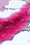
Those ice totals are ridiculous and most of SC would be in the dark.
Cary_Snow95
Member
We can literally see the start of the event on the 18z Nam tomorrowThis event starts at hour 96 on the euro…. That’s 3-4 days out View attachment 107167
Shaggy
Member
Man after that ice map @Myfrotho704_ posted I really hope the euro is off.id be lights out for a few days.
Attachments
000
FXUS62 KCAE 170621
AFDCAE
Area Forecast Discussion
National Weather Service Columbia SC
121 AM EST Mon Jan 17 2022
The ensemble means have clearly showed the large scale pattern with good
agreement heading into Friday, with a broad and deep trough sinking
across the eastern CONUS following the front. Extreme uncertainty
arises over if/where/when a diving shortwave will ride down the
backside of this trough. The run to run variance in operational,
blend, and ensembles has been very high so confidence is honestly
decreasing in the overall pattern for next weekend. So all that
needs saying at this time is: the overall synoptic pattern is
somewhat favorable for a Gulf/coastal system to develop and enough
cold air would be present for a possible frozen precip event. The
upstream interaction of the rapidly deepening low from Sunday`s
system needs to be cleared up before a more consistent signal can be
worked out.
joehoo
Member
DT at WXrisk did say 24 hrs ago that there is a risk that the low COULD be pulled to track inland.Man after that ice map @Myfrotho704_ posted I really hope the euro is off.id be lights out for a few days.
Sent from my LGMP260 using Tapatalk
EPS Mean followed along with the Euro Op in showing a wave evolution that was more conducive to increased precip chances compared to its last run. Here is the EPS Mean snow output on SV (don't know the specifics on the ptype algorithm)

NBAcentel
Member


Definitely ZR/IP on the mean; just not sure where it sets up. I think we all want to see 0c 850 as far South from their back yard as possible at this lead time.