NBAcentel
Member
That’s the one I’m really interested in, not the one lizard lick posted
That’s the one I’m really interested in, not the one lizard lick posted
@Parker Can you post one for Phenix City Alabama asking for a friend
Wait until it's well defined that there will be two destinct waves.This thread is already confusing. How should be split/break this down? Or is everyone good with multiple waves/chances discussed all in here?
There it is. Based on the GEFS look, probably gonna be more overrunning with threat #1.
Almost every member got Friday wave.
Pic?So far GEFS reducing snow on I-20, increasing mean on I-40
Keep it in here pleaseThis thread is already confusing. How should be split/break this down? Or is everyone good with multiple waves/chances discussed all in here?
Yes. We already know the progression here. Why? Because we've seen it 10,000,000 times. Can you tell me what's missing from this image in the spot that's marked? Hint: It's the secret ingredient for board-wide snowstorms.@Rain Cold. Check the last 5 runs out , went from central gulf to running inland here almost
View attachment 106938


A once inch mean at this range I'll take
Yeah I like keeping them together right now until we get a little clarity on the leading waveI think this is best. @SD

I was thinking the same thing. I looking at next Sunday system but others are looking at a midweek system and a Friday system. I’m confusedThis thread is already confusing. How should be split/break this down? Or is everyone good with multiple waves/chances discussed all in here?
Incredible, big overlap with cold and moisture. I'm going to buy me some chains for my car tires lol. Looks like we may see a slammer here.Just wow. When has this ever happened.
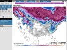
18z GEFS Ens Mean Snow on SV for Fri-Mon
If you want to really shoot for the stars we could make 2 out of this. With overrunning initially and a more wound up trailer waveMy sense is there are not actually going to be two storms as this develops. A stationary front with a wave forming?
Good news is overrunning precip totals can be crazy undermodeled.Wow, that is about a pretty of a setup as ever for central/south Alabama. Let’s go!
Grit posted a gif earlier of my thinking honestly. It's not uncommon to have multiple waves ride along a stalled out Arctic front giving smaller events, and something I'm honestly rooting for right now. Instead of one big bad wave that MAY over amplify.My sense is there are not actually going to be two storms as this develops. A stationary front with a wave forming?

I tend to agree with this statement but this is something we haven't seen in many years. A VERY strong front which stalls off of the coast then over running moisture. These come in waves. The models are having a hard time with a consistent solution, thus the ensembles are the way to go. Something is most likely going to occur next Friday, Saturday, or Sunday but is it going to be one day or multiple?My sense is there are not actually going to be two storms as this develops. A stationary front with a wave forming?
I tend to agree with this statement but this is something we haven't seen in many years. A VERY strong front which stalls off of the coast then over running moisture. These come in waves. The models are having a hard time with a consistent solution, thus the ensembles are the way to go. Something is most likely going to occur next Friday, Saturday, or Sunday but is it going to be one day or multiple?