uncjibble
Member
Light snow in Garner!


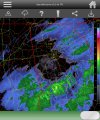
Why would this be virga when dews are pretty saturated?A lot of what is currently depicted on radar in North Georgia is Virga.
I haven't seen a single report on social media of this. Shirley folks aren't submitting false reports.mPing report of snow in Gwinnett County, Georgia
I haven't seen a single report on social media of this. Shirley folks aren't submitting false reports.


700 mb layer is really dry.Why would this be virga when dews are pretty saturated?


I see ya and I hear ya Phil. I'm right underneath them pretty colors in Atlanta and I ain't got so much as a bead of sweat
Yesssssir. Gonna have to change my handle!Turning into actually consistent snow now. Honestly the best snow I've seen at the house in 3 years which is sad.
Virga? Or just localized flurries?I see ya and I hear ya Phil. I'm right underneath them pretty colors in Atlanta and I ain't got so much as a bead of sweat
EDIT- doesn't mean others haven't, but all the Twitters for the local TV stations around here are quiet. With 6 million folks under that, if it were snowing, I think we'd have visual evidence

It may not be too long, we’ll see.I see ya and I hear ya Phil. I'm right underneath them pretty colors in Atlanta and I ain't got so much as a bead of sweat
EDIT- doesn't mean others haven't, but all the Twitters for the local TV stations around here are quiet. With 6 million folks under that, if it were snowing, I think we'd have visual evidence

Nothing here.


Nothing here either, RosieNothing here.
") Such potential, gone with the wind. Oh, well, we have a sure fire, all of Ga event scheduled for next weekend....at least until the energy gets on shore, and the Ga. ip/sn curse can get a hold of it
Such potential, gone with the wind. Oh, well, we have a sure fire, all of Ga event scheduled for next weekend....at least until the energy gets on shore, and the Ga. ip/sn curse can get a hold of it Rosie,Nothing here.