NCWeatherhound
Member
If I was a storm named Jasper, I'd spit an extra half-inch of ice on folks, just to show my displeasure."Jasper"? That's what TWC is calling this?
If I was a storm named Jasper, I'd spit an extra half-inch of ice on folks, just to show my displeasure."Jasper"? That's what TWC is calling this?
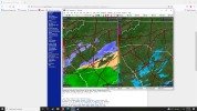
Probably low-topped. Unless my station isn't working anymore, I'm up to 36 with a DP of 35, so this is probably falling as all liquid provided it holds togeher.View attachment 109252WTF? Just popped up out of nowhere!

820
WWUS42 KCAE 212018
WSWCAE
URGENT - WINTER WEATHER MESSAGE
National Weather Service Columbia SC
318 PM EST Fri Jan 21 2022
SCZ021-027-028-031-220700-
/O.UPG.KCAE.WW.Y.0002.000000T0000Z-220122T1200Z/
/O.EXA.KCAE.WS.W.0001.000000T0000Z-220122T1200Z/
Fairfield-Lexington-Richland-Sumter-
Including the cities of Winnsboro, Winnsboro Mills, Seven Oaks,
West Columbia, Cayce, Lexington, Red Bank, Oak Grove, Columbia,
and Sumter
318 PM EST Fri Jan 21 2022
...WINTER STORM WARNING IN EFFECT UNTIL 7 AM EST SATURDAY...
* WHAT...Heavy mixed precipitation. Snow accumulations of up to
two inches and ice accumulations of up to one tenth of an inch.
* WHERE...Fairfield, Lexington, Richland and Sumter Counties.
* WHEN...Until 7 AM EST Saturday.
* IMPACTS...Plan on slippery road conditions. The hazardous
conditions could impact the morning or evening commute.
PRECAUTIONARY/PREPAREDNESS ACTIONS...
If you must travel, keep an extra flashlight, food, and water in
your vehicle in case of an emergency.
The latest road conditions for the state you are calling from can
be obtained by calling 5 1 1.
&&
$$
152
FXUS62 KCAE 212023
AFDCAE
Area Forecast Discussion
National Weather Service Columbia SC
323 PM EST Fri Jan 21 2022
.SYNOPSIS...
Winter Weather headlines remain in effect for the SC Midlands
and much of the CSRA through tonight. Precipitation will be at a
minimum for most of the day, but expect moisture to move back
into the region this afternoon and into early tonight, with a
wintry mix of freezing rain, sleet and snow expected.
Precipitation ends from west to east Saturday morning, with cold
air settling into the region lasting into next week. The next
chance for rain is possible by Tuesday, with dry conditions
returning thereafter.
&&
.NEAR TERM /UNTIL 6 AM SATURDAY MORNING/...
Based on recent radar developments, wet bulb obs, and the continual
guidance trends towards a heavy band of snow developing later this
evening, the Winter Storm Warning has been expanded to
Fairfield, Lexington, Richland, and Sumter counties. The Winter
Weather Advisory has been expanded to Lincoln and McCormick
counties. Confidence remains the highest across the northern
Midlands and Pee Dee, with sleet and freezing rain sharply
dropping snow totals across the southern Midlands. The potential
banding into the snow shield over the central and northern
Midlands will inevitably lead to a sharp fall off to the west
in snowfall totals. There remains quite a bit of uncertainty of
exactly where this band sets up but 0.5"+ per hour snow rates
are possible in any banding. Regardless, expect rapidly
deteriorating road conditions this evening and into the
overnight.
Ice accumulations expected between 0.1"-0.25" across the eastern and
southern Midlands, less than 0.1" elsewhere. Snow/sleet
accumulations will be highest over areas in the northern portion of
the Winter Storm Warning, with around 2-3" accumulation and isolated
higher amounts possible. Amounts then decrease to the south and
west, with around 1.5 - 2" through the Columbia metro and up to 1"
into the Augusta area through early Saturday morning. Low
temperatures tonight in the low to mid 20s allowing for fairly
efficient accumulation, with warmest values in the CSRA and
coldest temperatures near the SC/NC border.
The system will quickly exit out of the fa by early Saturday
with all PoPs falling off after 12z.
&&
TWC areas have rain and snow around some of the surrounding cites!Probably low-topped. Unless my station isn't working anymore, I'm up to 36 with a DP of 35, so this is probably falling as all liquid provided it holds togeher.
Yeah and like I said above… GSP is still going with 10-13:1 in their forecast…here she goes View attachment 109274
Flurries in SE Wake. We're rollin!

The precip shield is expanding tooProbably low-topped. Unless my station isn't working anymore, I'm up to 36 with a DP of 35, so this is probably falling as all liquid provided it holds togeher.

 Just cloudy here- no precip
Nothing falling in Forest Park, GA.Probably low-topped. Unless my station isn't working anymore, I'm up to 36 with a DP of 35, so this is probably falling as all liquid provided it holds togeher.
That is a thing of beauty!18z 1km NAM loop

I’ve noticed in some of the modeling, including this one, some SW/NE banding that sets up further west and increases totals greatly. The GFS did this as the NAM. Could make it so that areas outside of the warned zone really outperform even compared to the warned areas. I’m a weenie, but it’s a possibility I’m seeing.18z 1km NAM loop

That's like 10 hours of snow. That will work.That is a thing of beauty!


Jasper's in town!Flurries in SE Wake. We're rollin!
Radar shows precip down to about 2500 feet now around the Atlanta area. So if it holds and doesn't evaporate some flakes should hit the ground within an hour where its cold enough.. Tilt 2, 3, and 4 on radar shows it still increasing.Nothing falling in Forest Park, GA.
A lot of what is currently depicted on radar in North Georgia is Virga.
I have this radar app, what id the best tilt combo for real depiction?Radar shows precip down to about 2500 feet now around the Atlanta area. So if it holds and doesn't evaporate some flakes should hit the ground within an hour where its cold enough.. Tilt 2, 3, and 4 on radar shows it still increasing.
I’m looking more at central GA/SCA lot of what is currently depicted on radar in North Georgia is Virga.