GFS here shows 500mb mid-upper level vertical motion and moisture increasing late this afternoon into this evening. Will be an abrupt end to the snow on the backside and blue skies in the morning for early pictures


Thing almost went comma head there near the endGFS here shows 500mb mid-upper level vertical motion and moisture increasing late this afternoon into this evening. Will be an abrupt end to the snow on the backside and blue skies in the morning for early pictures
Can you nudge that a little higher. I’m right on the edge here in Huntersville.Final call. Can’t help but go bullish with the way things look OBS wise, had to rush this one tho because I’m at work View attachment 109180
 Final euro run before go time
Yea radar is looking great. Optimistic here in se Charlotte.
 HRRR continues to play catch-up and improve

What's your call for Raleigh KyloG?
Per my wife who at our home in Wingate, there is some very light snow falling… I’m at work in Stallings and so far haven’t seen anythingVirga, let’s see if it can start to make it down to the ground
View attachment 109179
Interesting. Nothing here in Waxhaw yet.Per my wife who at our home in Wingate, there is some very light snow falling… I’m at work in Stallings and so far haven’t seen anything
What's your call for Raleigh KyloG?

Man 2 inches is massive for a place that hasn’t seen widespread 1 inch totals in nearly 8 years.I'm expecting around 1-2.5 inches of snow for Columbia and 0.5-2 inches for Aiken/Augusta. Nothing major,but just enough snow to keep us satisfied until next winter or atleast we get a pattern that conductive for a big snowfall around here. Wish us luck to truly finally our snowless streak broken today.
Man 2 inches is massive for a place that hasn’t seen widespread 1 inch totals in nearly 8 years.
Are we gonna be in for a nice surprise? Or just some flurries.Looking at the COD radars and the moisture is just streaming northward. As far north as northern Alabama and East TN

Do they have a high end potential?

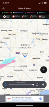
It something seeing the radar beginning to fill in like that… even though it’s light stuff. The best upper dynamics are still well back to the west and won’t be here for a few hours stillThis is a classic pre snow storm look on radar View attachment 109197