Not hitting the groundThat's a lot of precip in SC that's going to have to go due east to miss us. It's already as far west as Charlotte.
-
Hello, please take a minute to check out our awesome content, contributed by the wonderful members of our community. We hope you'll add your own thoughts and opinions by making a free account!
You are using an out of date browser. It may not display this or other websites correctly.
You should upgrade or use an alternative browser.
You should upgrade or use an alternative browser.
Wintry January 3rd-6th, 2018 Winter Storm The ARCC/Xtreme Weather Special
- Thread starter TheBatman
- Start date
Virga is good. It moistens up the air. Let it fall.
Columbia taking the shaft real hard with this one. Chalk it up as another disappointment. Either dry air, to warm, warm nose. Always something.
It's a disappointment, as seeing folks further east, south, and southeast get in on the snow while we sit in a virga storm.
It's also cool to see several folks who rarely see it get in on the "fun." Unfortunately, it's not gonna work out for our area.
Thankfully, I'm no longer emotionally invested in this stuff any longer, and just move on. It's always better to have it in your backyard. But if you really wanna see it, then head to the Lower Midlands, Pee Dee, Grand Strand or Lowcountry.
Looks like some good convective activity along/off the GA and SC coasts now.
metfascination
Member
Hilton Head:

Sent from my iPhone using Tapatalk

Sent from my iPhone using Tapatalk
Brett
Member
Ice stormHilton Head:
Sent from my iPhone using Tapatalk
Hrrr slowly continues to inch NW
Sent from my SM-G955U using Tapatalk
Sent from my SM-G955U using Tapatalk
Blue_Ridge_Escarpment
Member
Hilton Head:
Sent from my iPhone using Tapatalk
Wow. Shelter Cove Harbor. One of my favorite places at HHI. This is right across from the Disney resort there.
Lol you beat me to it. Come on man, you know I have HRRRRR duty!Hrrr slowly continues to inch NW
Sent from my SM-G955U using Tapatalk
You can have 19zLol you beat me to it. Come on man, you know I have HRRRRR duty!
") I'll take flurry watch
I'll take flurry watchSent from my SM-G955U using Tapatalk
Haha you got it.You can have 19z
Sent from my SM-G955U using Tapatalk

tonysc
Member
Frustrating isn't is Brick?Can't win here. I don't think we have a good idea what we need to get snow here anymore. It seems when we do lately it's usually a last minute surprise, like with the Christmas 2010 storm.
When the models do show a huge storm, the setup says no and the models end up being wrong. When we have a great setup, the models say no and end up being right.
NW trend....NW trend it's our friend.... That NW trend

Sent from my SM-G955U using Tapatalk

Sent from my SM-G955U using Tapatalk
This looks just like I thought it would with a coastal. Cant help the dryair/virga though: Atleast I wasnt that off looking at H5

Hrrr with some nice 850mb convergence along US1 might be just enough to enhance snowfall

Sent from my SM-G955U using Tapatalk

Sent from my SM-G955U using Tapatalk
Webberweather53
Meteorologist
Only 25-30 more miles to go NW and Raleigh will be inside the 3-5" that's over central Johnston County on the HRRR. Gonna be close

I swear man trying it's best to get .5 qpf back to me, it continues to show it pivot which holds precip over me just a little longer... just don't know if I trust it lolNW trend....NW trend it's our friend.... That NW trend
Sent from my SM-G955U using Tapatalk

Sent from my SM-G920V using Tapatalk
Umm weenie mby question but can you post that at the end of its run? ThanksOnly 25-30 more miles to go NW and Raleigh will be inside the 3-5" that's over central Johnston County on the HRRR. Gonna be close
View attachment 2602
Sent from my SM-G920V using Tapatalk
B
Brick Tamland
Guest
Maybe it'll follow tradition and the higher totals will end up NW of what the models show.Only 25-30 more miles to go NW and Raleigh will be inside the 3-5" that's over central Johnston County on the HRRR. Gonna be close
View attachment 2602
Jack Roney
Member
Listen... I don't want to be the guy who re-hypes this thing up.... but 2 hours ago, Johnston Co (JoCo for my folk around here) had .25-5in of snow. This latest HRRR trend has them in 4-5in -- THAT IS MOVEMENT PEOPLE!
That's 10:1 ratios too. Should do a bit better than that, I would think.Only 25-30 more miles to go NW and Raleigh will be inside the 3-5" that's over central Johnston County on the HRRR. Gonna be close
View attachment 2602
Webberweather53
Meteorologist
Umm weenie mby question but can you post that at the end of its run? Thanks
Sent from my SM-G920V using Tapatalk
Yep! Figure this is 10:1 and w/ temps in the mid 20s, you can jack these numbers up by 30-50%. HRRR is really showing 5-6" in your neck of the woods and the storm isn't over yet by hr 15...

Webberweather53
Meteorologist
Exactly... We are right on the cusp, if we get into the meat of the storm it will be by the skin of our teeth...That's 10:1 ratios too. Should do a bit better than that, I would think.
packfan98
Moderator
Here's the Kuchera clown map for the hrrr:

Webb, you see anything about the organization/trends of this system that would lead you to believe further westward adjustments (perhaps significant) would be possible?Exactly... We are right on the cusp, if we get into the meat of the storm it will be by the skin of our teeth...
Webberweather53
Meteorologist
Webb, you see anything about the organization/trends of this system that would lead you to believe further westward adjustments (perhaps significant) would be possible?
Yeah, the HRRR is consistently overzealous w/ the convection well offshore as of late which is why our low center has come further NW in recent runs and the convection that was evident earlier just east of GA/FL has waned and become more diffuse vs its forecast which helps w/ moisture transport further northwest.
Webberweather53
Meteorologist
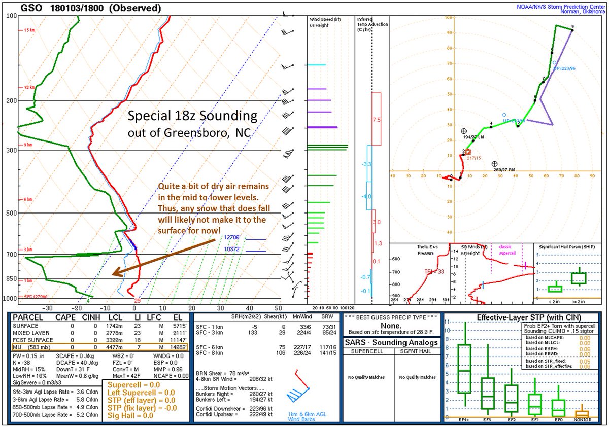
Light snow is already being reported in Rockingham, NC and its accumulating immediately... So yea, not all of this is virga apparently and some of it is reaching the ground in the southern piedmont.
Thanks. You mentioned instant occlusion earlier and I wanted to ask, but things were kind of hectic then. When an instant occlusion takes place, does the system have more of a tendency to maintain a consolidated look and strengthen rapidly from there? The reason I ask, is because the models were showing all of these multi-low scenarios. That is not what I would expect to see with an instant occlusion scenario. Of course, that may be just because I am wrong in thinking that.Yeah, the HRRR is consistently overzealous w/ the convection well offshore as of late which is why our low center has come further NW in recent runs and the convection that was evident earlier just east of GA/FL has waned and become more diffuse vs its forecast which helps w/ moisture transport further northwest.
Radar looking good in SE part of NC also, slowly creeping NW
Sent from my SM-G920V using Tapatalk
Sent from my SM-G920V using Tapatalk
And as expected the low dew points/dry air won out from CAE and especially West from there. This is what I talked about yesterday, that some ignored and said it was overdone.
I saw a total of a flizzard in Lexington.
I saw a total of a flizzard in Lexington.
jaymackd3
Member
Bummer Shawn...I'd much rather know I'm not getting any snow then have it so close or even showing on the radar only to see nada bc of the dry air.And as expected the low dew points/dry air wont out from CAE and especially West from there. This is what I talked about yesterday, that some ignored and said it was overdone.
I saw a total of a flizzard in Lexington.
ForsythSnow
Moderator
Yep, the dew point argument is indeed valid. Let's remember that next time we have a flizzard chance. Saw absolutely nothing here and am not bothered by it. Had my good snow for the winter already, and looks like we may see ice soon.And as expected the low dew points/dry air wont out from CAE and especially West from there. This is what I talked about yesterday, that some ignored and said it was overdone.
I saw a total of a flizzard in Lexington.
WIS still calling for 2 inches in Columbia. Fail!
For the Eastern sections, not out of the question. But CAE/West Columbia, West - no way no way.WIS still calling for 2 inches in Columbia. Fail!
SimeonNC
Member
I think it's pretty early to call this a bust imo.
Wasn't supposed to be much of anything this far West in SC anyway. Who knows about NC, you guys handle those forecasts better than I could. I can say the RAP radar on my end earlier didn't look promising.I think it's pretty early to call this a bust imo.
GeorgiaGirl
Member
Like I said earlier, you really need to be somewhat close with dewpoints to see light snow. Like 10 degree difference, maybe 15 max. 20+ is too much though and it's enough to where even if you have greens over you, you're going to see next to nothing fall at all.
Webberweather53
Meteorologist
Thanks. You mentioned instant occlusion earlier and I wanted to ask, but things were kind of hectic then. When an instant occlusion takes place, does the system have more of a tendency to maintain a consolidated look and strengthen rapidly from there? The reason I ask, is because the models were showing all of these multi-low scenarios. That is not what I would expect to see with an instant occlusion scenario. Of course, that may be just because I am wrong in thinking that.
Yes, the system strengthens rapidly because in an instant occlusion process at the large-scale a shortwave is rotating within the base of an upper level trough and the incipient disturbance catches up w/ a residual arctic frontal boundary and effectively strengthens the temperature (baroclinicity) and vorticity advection over it. Essentially what this looks like on satellite is you'll see (as we saw this morning) a baroclinic leaf cloud structure develop to the west of an elongated moderate-deep cloud mass and as time progresses, this will overrun this cloud mass associated with the arctic front and it'll eventually create a classic comma head structure to the storm that's often associated w/ stereotypical monster extratropical cyclones
Webberweather53
Meteorologist
A feeble CAD wedge has tried to establish itself over portions of the NC piedmont as indicated by the pressure ridge nosing in east of the Apps, this could further aid w/ lift...
