iGRXY
Member
I definitely think we have a storm over 100mph now.
They are putting it at 90mph with the 2pm ET update, but I think you’re right. It looks like it’s going bombs away now.I definitely think we have a storm over 100mph now.
They are putting it at 90mph with the 2pm ET update, but I think you’re right. It looks like it’s going bombs away now.

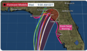
Yeah I see no reason NHC does not shift their track west some at this point. I don't think there is a single model left that has it going over their trackEuro moved to the western edge of the cone
View attachment 136625
By 2PM today; she should be quite impressive. Anything earlier than that; Bonus.
I think we're at the point now where we should just expect systems in the Gulf to do this.Just food for thought, that IR is so similar to Harvey, Michael, Ida and Ian at this stage. Almost the same bumbling look that never fully closes off the eyewall yet allows for steady strengthening until the storm pulls it all together before landfall; thus the ERC comes too late. Not good.
I think we're at the point now where we should just expect systems in the Gulf to do this.
I think we're at the point now where we should just expect systems in the Gulf to do this.
I think it’s due to them moving it every update in the past. I agree that it’s definitely west of guidance though!Yeah I see no reason NHC does not shift their track west some at this point. I don't think there is a single model left that has it going over their track
You still going Panama City to Atlanta?I told you guys last night this was going to go more westerly.
Who came up with this name? seriously, never heard of it and I have many Amigas/Amigos.
Maybe not that far west. Apalachicola, then NNE.You still going Panama City to Atlanta?
More of an Italian name, very popular thereWho came up with this name? seriously, never heard of it and I have many Amigas/Amigos.
Never heard of an Idalia onion?Who came up with this name? seriously, never heard of it and I have many Amigas/Amigos.
My aunt's middle name is IdaliaWho came up with this name? seriously, never heard of it and I have many Amigas/Amigos.
Levi mentioned in his video she might not go as far east as forecast due to the ridge building back inLooks like the circulation is trying to cross West over 85 degrees :O
It is going west for landfall but farther south and east up in the Carolinas. The Euro has it back offshore close to Georgetown now.I told you guys last night this was going to go more westerly.
The euro has been too far east this entire time compared to other guidance.It is going west for landfall but farther south and east up in the Carolinas. The Euro has it back offshore close to Georgetown now.
Shetley is bittercasting like usual. I thought @packfan98 made a post earlier today about posting no sense in this thread.The euro has been too far east this entire time compared to other guidance.
Ok I’ve just looked at the 12z Euro out to hour 57 and that is not the case. It still has it exiting right about Myrtle Beach, maybe just tad north of there. Also, GSP hasn’t put out their afternoon discussion yet, but they have gone ahead issues a Flash Flood Watch for the SC Upstate and the southern NC Piedmont for 2-4 inches of rainfall expected.It is going west for landfall but farther south and east up in the Carolinas. The Euro has it back offshore close to Georgetown now.
Also I still don’t think that the EURO/UK combo is doing a very good job at expanding precip on the NW side. There’s a lot of dynamics at play that should spread rain back to the mountains at least for a time.I definitely could see 2-4" all across the upstate as we get some additional upslope my way and heavier returns back towards the southeast. Don't be surprised to see a line of 3-6" from Greenwood to Union and back towards Rock hill either.
Yes…. I expect the 3k NAM and the HRRR as it gets closer will start to pick on heavier rain further to the north and west of the center.NAM 3k picking up on heavier amounts in Central NC...probably why GSP is waiting on Disco and hoisting FFW.
It's showing some high amounts with the 12z run.Yes…. I expect the 3k NAM and the HRRR as it gets closer will start to pick on heavier rain further to the north and west of the center.

Going to rocket NE by tomorrow.. So the filed may be wide
Vidilla... but I think it's going more west then they think. I think models are missing something .Never heard of an Idalia onion?
One thing to be careful of is, though it's easy to extrapolate a more westward and northward inland track, based on a more current westerly motion (and even a bit more of a westerly landfall) than the official forecast plot indicates, shortly after landfall, most models make a hard right and still eventually end up pretty close to the same track.Postel just posted this...leaning a bit left....bigger ramifications further north (Central SC/NC)