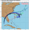
12z track cycle has tightened back up, might be a shift west, I'm not sure but for your viewing pleasure lol


I haven't seen one run west of 85N so I think we are good.I would say any models that show this landfall WEST of 85N or likely wrong. IMO... I like a Cedar Key to Lake City to Savannah line. map soon.

Anybody have 06z EURO landfall?

The 6z Euro was very close.Is there any chance the eye could go directly over Tallahassee ?
Tallahassee is on the left edge of the NHC cone. So, yes.Is there any chance the eye could go directly over Tallahassee ?
I'm no expert but almost all tracks suggest this is going to go over Tallahassee, or at least have significant impact for Tallahassee.Is there any chance the eye could go directly over Tallahassee ?
Well east compared to what? It basically followed the 6z EuroNAM is well east. Time to forget about this dropping any rain in this area.
12z NAM east of 6z NAM. Was near Sumter on 6z now back to about 20 miles inland at 12Well east compared to what? It basically followed the 6z Euro
Cedar Key might be too far east.. it seems to be right on the eastern edge of latest guidance. Definitely think it’s not going in west of 85N.I would say any models that show this landfall WEST of 85N or likely wrong. IMO... I like a Cedar Key to Lake City to Savannah line. map soon.
And the 3K is well west. Just ignore it at this point cause they're going to SPAM the hell out of the drought thing and no rain like they're getting cash for each post.Well east compared to what? It basically followed the 6z Euro
Ok…understood. It did pretty much follow the 6z Euro though and that brought some fairly heavy rainfall to the eastern SC Upstate and southeast NC Piedmont12z NAM east of 6z NAM. Was near Sumter on 6z now back to about 20 miles inland at 12

Yeah that's not getting a bunch of attention but it will be moving quick at landfall, you are correct, could be a large area of power outagesThe storm is going to come roaring into the NE Florida panhandle with a brisk forward speed of nearly 20mph. High winds will extend further inland than is usual for a landfalling GOM cane this time of year.
I'm surprised they didn't expand the cone west from everything we're seeing on the model runs. People only have today to evacuate.NHC not buying what the NAM (and HRRR tbh) is selling just yet, seem pretty locked in on the track

To be fair, NHC always waits a few model runs before adjusting. If there are like 3 runs of the GFS that shift west, they will finally start making adjustments and they don’t do knee jerk reactions to one run. They were really bad about this last year. But the track does have a very tight cluster at this moment, will be fun to watchNHC not buying what the NAM (and HRRR tbh) is selling just yet, seem pretty locked in on the track

Their tracks are always to a Tee what the spaghetti plots show. Maybe a touch of variation but I never see them do anything but maintain the track based on whatever the latest run was. For example the track above is like identical to the most recent spaghetti run a couple of hours ago:NHC not buying what the NAM (and HRRR tbh) is selling just yet, seem pretty locked in on the track


The track is usually within a general area of other guidance. It's the strength that it always WAYYYYY over exaggerates. But oddly enough the most recent update is right in lock step with the Hurricane models strength wise.Genuine question: has the NAM ever been known for any degree of accurate forecasting for tropical systems? Happy to look at weenie maps but as far as I remember it always over amplifies intensity and is not exceptionally accurate for track either.
No. It has never, ever been considered a reliable tropical model. I tried to make that point last night, and it was met with sarcasm about only believing in the Euro...or some such nonsense. I still maintain that last night's run (and today's 12z 3K run) tracking it near Columbia and into the NC coastal plain is too far west/north. But we'll see.Genuine question: has the NAM ever been known for any degree of accurate forecasting for tropical systems? Happy to look at weenie maps but as far as I remember it always over amplifies intensity and is not exceptionally accurate for track either.
That seems like a very dangerous recipe to only base it off spaghetti plots when most models are showing it west. Especially this close.Their tracks are always to a Tee what the spaghetti plots show. Maybe a touch of variation but I never see them do anything but maintain the track based on whatever the latest run was. For example the track above is like identical to the most recent spaghetti run a couple of hours ago:
View attachment 136612
Right now those a further east vs what a lot of the global and mesoscale models are currently showing.
Yeah but to be fair there are H warnings outside of the cone, so in theory those areas should still be preparingI'm surprised they didn't expand the cone west from everything we're seeing on the model runs. People only have today to evacuate.
No.Genuine question: has the NAM ever been known for any degree of accurate forecasting for tropical systems? Happy to look at weenie maps but as far as I remember it always over amplifies intensity and is not exceptionally accurate for track either.
