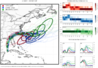
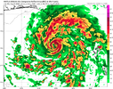
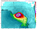
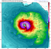
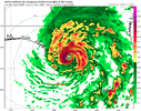
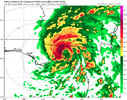
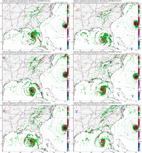
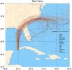
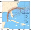
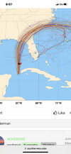
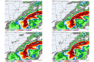
Everything isn't about NC, it's a west trend for LF but slowing and moving east as it approaches NC. Also look at precip maps, they definitely trended W/NW, your too hyper focused on the center and your backyardI thought there was a west trend. Those look farther south and east as it relates to previous tracks into NC.
-
Hello, please take a minute to check out our awesome content, contributed by the wonderful members of our community. We hope you'll add your own thoughts and opinions by making a free account!
You are using an out of date browser. It may not display this or other websites correctly.
You should upgrade or use an alternative browser.
You should upgrade or use an alternative browser.
Tropical Hurricane Idalia
- Thread starter weather nerd
- Start date

GOES-19 - Sector view: Gulf of America - Band 13 - NOAA / NESDIS / STAR
Near real-time publication of GOES-East and GOES-West images from NOAA/NESDIS/STAR

By 2PM today; she should be quite impressive. Anything earlier than that; Bonus.
Getting it's act together
- Joined
- Jan 23, 2021
- Messages
- 4,602
- Reaction score
- 15,197
- Location
- Lebanon Township, Durham County NC
It wouldnt take much for areas north of 85 in the triangle to get blanked by this. Already just a couple hundreths on the euro.
SimeonNC
Member
Area Forecast Discussion
National Weather Service Tallahassee FL
510 AM EDT Tue Aug 29 2023
...IDALIA EXPECTED TO SLAM THE FLORIDA BIG BEND AS A MAJOR HURRICANE
EARLY WEDNESDAY MORNING...
...New NEAR TERM, SHORT TERM, LONG TERM, AVIATION, MARINE, FIRE WEATHER, HYDROLOGY...
.NEAR TERM...
(Today)
Issued at 504 AM EDT Tue Aug 29 2023
You need to complete your preparations today if you live in the
Florida big bend. To put this system into the historical context,
there are NO major hurricanes in the historical dataset going back
to 1851 that have tracked into Apalachee Bay. None. Don`t mess
around with this. Follow the advice of your local emergency
management.
SimeonNC
Member
Also from what I've seen more models have Idalia exiting off the NC coast around Wilmington rather than Myrtle or Charleston
OK, so it's not a west trend for everyone that could be impacted in NC.Everything isn't about NC, it's a west trend for LF but slowing and moving east as it approaches NC. Also look at precip maps, they definitely trended W/NW, your too hyper focused on the center and your backyard
Looks like she's down to 974 or so on early pass this morning
theres going to be a sharp cut off with precip in NC because of the front bringing in dry air - precip will be fighting dews in the 40s and low 50s
OK, so it's not a west trend for everyone that could be impacted in NC.
Yes and no. With the jet sitting where it's at and the old front at different layers potentially getting stuck models are more adjusting the heavier precip shield N of the track
BULLETIN
Hurricane Idalia Intermediate Advisory Number 11A
NWS National Hurricane Center Miami FL AL102023
700 AM CDT Tue Aug 29 2023
...NOAA HURRICANE HUNTERS FIND IDALIA STRENGTHENING...
SUMMARY OF 700 AM CDT...1200 UTC...INFORMATION
----------------------------------------------
LOCATION...23.8N 84.8W
ABOUT 135 MI...215 KM WSW OF THE DRY TORTUGAS
ABOUT 320 MI...515 KM SSW OF TAMPA FLORIDA
MAXIMUM SUSTAINED WINDS...80 MPH...130 KM/H
PRESENT MOVEMENT...N OR 005 DEGREES AT 14 MPH...22 KM/H
MINIMUM CENTRAL PRESSURE...977 MB...28.85 INCHES
DISCUSSION AND OUTLOOK
----------------------
At 700 AM CDT (1200 UTC), the center of Hurricane Idalia was located
near latitude 23.8 North, longitude 84.8 West. Idalia is moving
toward the north near 14 mph (22 km/h). A northward motion is
expected today, followed by a faster north-northeast motion later
today and Wednesday. On the forecast track, the center of Idalia is
forecast to move over the eastern Gulf of Mexico today, reach the
Gulf coast of Florida within the Hurricane Warning area on
Wednesday, and move close to the Carolina coastline on Thursday.
Data from a NOAA Hurricane Hunter aircraft indicate that maximum
sustained winds have increased to near 80 mph (130 km/h) with higher
gusts. Rapid intensification is likely through landfall, and Idalia
is forecast to become an extremely dangerous major hurricane before
landfall on Wednesday.
Hurricane-force winds extend outward up to 15 miles (30 km) from
the center and tropical-storm-force winds extend outward up to 160
miles (260 km).
The minimum central pressure based on dropsonde data is 977 mb
(28.85 inches).
Interesting discussion from the NHC about track guidance and can see what they are talking about with the EPS (someone else has better graphics I'm sure)
There has been a westward shift in the model guidance
overnight, perhaps due to the trough tugging Idalia more
northward before taking a north-northeast turn. It should be
noted that the ECMWF ensemble shows many of its strongest members
on the eastern side of its guidance envelope, which is a
reasonable place to be given the synoptic pattern. The new NHC
forecast is adjusted a little to the west but is now east of the
model consensus on the eastern side of the reliable model guidance.

Brent
Member
F. SPIRAL BAND
G. C20
Much more organized now
G. C20
Much more organized now
NoSnowATL
Member
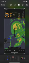
Definitely and eye looks almost completely closed on radar. Probably see it clear out on sat images later this morning or afternoonF. SPIRAL BAND
G. C20
Much more organized now
Good points. I know we are focused on the next 24-48 hours for this storm yet however more guidance is suggesting a loop back toward Florida or the southeast with slower redevelopment.Notice where the center is located currently, again these are subtle differences but the actual center seems to be more inline with the NHC track which is on the east side of guidance currently. It may tug westward at some point though, something to watch
View attachment 136603
Yeah, so we might not get many to track this year but the one we do, we will for days and days lolGood points. I know we are focused on the next 24-48 hours for this storm yet however more guidance is suggesting a loop back toward Florida or the southeast with slower redevelopment.
Nerman
Member
Anybody have 06z EURO landfall?
NoSnowATL
Member
Center is more west then your red dot.Notice where the center is located currently, again these are subtle differences but the actual center seems to be more inline with the NHC track which is on the east side of guidance currently. It may tug westward at some point though, something to watch
View attachment 136603
NoSnowATL
Member
So just throwing shade on Brick because of the past/previous! Got it!
Nope. I was actually agreeing with what Brick said and there was nothing negative, whatsoever in my post. I have never posted anything negative about Brick nor anyone else on here, including you. Not sure what your problem is.
Last edited:
It continued the trend of ticking back to the west. Landfall around the Jefferson/Taylor county line. That line would cause a big storm surge into Appalachee Bay. Also it looks Tallahassee could take a very big hit as well.Anybody have 06z EURO landfall?
Probably gonna see two intensification cycles, one to put it near MH strength today and tonight and another tomorrow.
JHS
Member
The 12z runs should tell us a lot about where this will go. Have to wonder how much farther west this can trend. As it stands it is getting awfully close to being a big rainmaker for the southeast part of the GSP county warning area.It continued the trend of ticking back to the west. Landfall around the Jefferson/Taylor county line. That line would cause a big storm surge into Appalachee Bay. Also it looks Tallahassee could take a very big hit as well.
NoSnowATL
Member
I don't see it going west of Ap Bay but that's still a nice west jog compared to the NHC track.The 12z runs should tell us a lot about where this will go. Have to wonder how much farther west this can trend. As it stands it is getting awfully close to being a big rainmaker for the southeast part of the GSP county warning area.
accu35
Member
Looks like it’s back on a due north track
Yeah I don’t think it goes any further west than St Vincent Island.I don't see it going west of Ap Bay but that's still a nice west jog compared to the NHC track.
Probably is but what the hell do I know, I was just looking at recon data, sorry center is on the left edge of the red dot.... damn we squabble over west, east, this spot that spot..... I'm not in the game, never really have been just trying to track it and have fun like everyone elseCenter is more west then your red dot.

NoSnowATL
Member
Either way I get nothing. HahaProbably is but what the hell do I know, I was just looking at recon data, sorry center is on the left edge of the red dot.... damn we squabble over west, east, this spot that spot..... I'm not in the game, never really have been just trying to track it and have fun like everyone else

BHS1975
Member
Hot towers going up NW quad.
Sent from my iPhone using Tapatalk
Sent from my iPhone using Tapatalk
Last edited:
Drizzle Snizzle
Member
You’ll probably get some clouds.Either way I get nothing. Haha

