Pass. Let’s go back to when this was tracking up through Atlanta.
-
Hello, please take a minute to check out our awesome content, contributed by the wonderful members of our community. We hope you'll add your own thoughts and opinions by making a free account!
You are using an out of date browser. It may not display this or other websites correctly.
You should upgrade or use an alternative browser.
You should upgrade or use an alternative browser.
Tropical Hurricane Idalia
- Thread starter weather nerd
- Start date
Henry2326
Member

Henry2326
Member
- Joined
- Jan 5, 2017
- Messages
- 3,802
- Reaction score
- 6,051
Yes, I agree, they spin moisture off to the northwest but there is a limit to how far it goes. I'm saying a track through Macon might be far enough north to get the NW rain shield to Atlanta, but a track through Valdosta will definitely not. I've lived here for 45 years. I've seen this scenario over two dozen times. It never fails. This is a south Georgia, northern Florida storm. AL and the rest of GA can ignore it.Look at my post above and then go and pull up the radar images of Gulf storms after landfall.
Henry2326
Member
24 hrs later 18z HWRF shifted slightly but still general intensity.

accu35
Member

Henry2326
Member
I don't see that happening.Pass. Let’s go back to when this was tracking up through Atlanta.
NewnanWetather
Member
Atlanta would be on the dry side if it moves Southeast of Atlanta right
Lived in Ga for 48 years in Atlanta. Had several storms come visit us in Newnan. Storms don't always stick to the models. You never turn your back on a storm. I know with Michael we had wind damage in Newnan. We got a few days to watch it.Yes, I agree, they spin moisture off to the northwest but there is a limit to how far it goes. I'm saying a track through Macon might be far enough north to get the NW rain shield to Atlanta, but a track through Valdosta will definitely not. I've lived here for 45 years. I've seen this scenario over two dozen times. It never fails. This is a south Georgia, northern Florida storm. AL and the rest of GA can ignore it.
Looks like the NHC has increased the intensity. Have it still as a tropical storm in NC now.

You know the 3k nam gonna give us some eye candy tomorrow

Eastern track preferred, TS force sustained winds along the coast more likely thus remains a TS throughoutLooks like the NHC has increased the intensity. Have it still as a tropical storm in NC now.
View attachment 136483

The NC Snow official call is Taylor County Fliorida landfall 948mb. Big surge that area as its in the funneld shepe big ben area. Lets hope my intensity is wrong.
Moist
accu35
Member

West this run
Tropical Cyclone forecast track SE trend right on queue:


Henry2326
Member
06z.....very tight band. Even tighter than 00z.
.png")
Henry2326
Member
.png")
iGRXY
Member
The swath of moisture will be extensive regardless of where it tracks. Plus with the stalled front, I’d say most of us will see several much needed inches of rain
My stepson and his wife are taking their boat down the Intercoastal Waterway from Southport to Charleston leaving this Friday. It looks like they would avoid the worst of the weather but I will advise them to delay their departure on Friday until this storm has cleared the coast. If they stick with their plans and leave Friday morning, it could be a very interesting trip for them to say the least looking at the GFS and EURO storm tracks.
BHS1975
Member
The swath of moisture will be extensive regardless of where it tracks. Plus with the stalled front, I’d say most of us will see several much needed inches of rain
SE NC will get most of it.
Sent from my iPhone using Tapatalk
Looks like they slowed it down a tan.
Henry2326
Member
4:00 am NHC discussion......
The very warm and deep waters of the northwestern Caribbean Sea and
Gulf of Mexico should support at least gradual strengthening during
the next few days, tempered by moderate shear from a flat upper-
level trough. However, this trough is forecast to amplify over the
western Gulf of Mexico around Tuesday, which causes the shear to
decrease near the cyclone in that time frame.
●●●● There's a notable risk of rapid intensification while the system moves across the record warm eastern and northeastern Gulf of Mexico, which is highlighted by the recent HAFS and HWRF guidance.
The new NHC
forecast is raised from the previous one, near or above the model
consensus, and could be too low. I'm reluctant to make any big
changes to the forecast until we get more in-situ data, but the
upward overnight model trend certainly bears watching. Users are
reminded to continue monitoring forecasts for any changes to the
system's expected intensity as it approaches Florida.
Something worth noting this morning. What makes it difficult to forecasts these type of storms is the location. Here is a projected path of TD 14 back in 2018:
Possibly the biggest environmental factor favoring its rapid intensification would be the very warm Gulf waters ahead of the storm. This was an ahead of TD 14.

Now: this is our current TD 10 projected path.

And the waters ahead of TD 10:

This morning TD 10 is actually move due S at 5 mph. Something TD 14 in 2018 didn’t do. There is an upper-level trough over the northeast which has greatly influenced TD 14 in 2018. Which was later Hurricane Michael. A similar situation is happening now with less shear coming from Belize. Here is the EURO trend.

I personally see elements to support RI correct me if I’m wrong. Environmental factor that potentially helped Michael intensify rapidly may be attributed to the upper level trough that steered the storm NW just before landfall. Usually, mid-latitude systems such as troughs bring very unfavorable environmental conditions for tropical cyclones (i.e., strong upper-level shear).
Possibly the biggest environmental factor favoring its rapid intensification would be the very warm Gulf waters ahead of the storm. This was an ahead of TD 14.
Now: this is our current TD 10 projected path.
And the waters ahead of TD 10:
This morning TD 10 is actually move due S at 5 mph. Something TD 14 in 2018 didn’t do. There is an upper-level trough over the northeast which has greatly influenced TD 14 in 2018. Which was later Hurricane Michael. A similar situation is happening now with less shear coming from Belize. Here is the EURO trend.
I personally see elements to support RI correct me if I’m wrong. Environmental factor that potentially helped Michael intensify rapidly may be attributed to the upper level trough that steered the storm NW just before landfall. Usually, mid-latitude systems such as troughs bring very unfavorable environmental conditions for tropical cyclones (i.e., strong upper-level shear).
Attachments
Interesting south movement overnight. I see the storm didn't quite make it to TS overnight which I find surprising, but it shouldn't be long now.
Assuming it avoids land interaction, this more southern launching point would suggest a stronger, more developed storm as it moves into the GOM tomorrow.
The storm's forward motion as it nears landfall and beyond will be rather fast. This would bring strong winds further inland assuming an intense storm, while greatly reducing the risk of severe inland flooding.
It does look to be moving fairly quickly when it makes landfall. One problem is though that with the stalled out front and the flow in front of the storm is that there could be very heavy rainfall setting up well out ahead of the storm… so some areas could see as long a duration rain event as you see with a slow moving TCInteresting south movement overnight. I see the storm didn't quite make it to TS overnight which I find surprising, but it shouldn't be long now.
Assuming it avoids land interaction, this more southern launching point would suggest a stronger, more developed storm as it moves into the GOM tomorrow.
The storm's forward motion as it nears landfall and beyond will be rather fast. This would bring strong winds further inland assuming an intense storm, while greatly reducing the risk of severe inland flooding.
Heavy rain is pretty much a given over portions of the SE next week. But, at least we aren't talking about (I don't think) many areas of >10 inches of rain as so often happens with a slow-moving system.It does look to be moving fairly quickly when it makes landfall. One problem is though that with the stalled out front and the flow in front of the storm is that there could be very heavy rainfall setting up well out ahead of the storm… so some areas could see as long a duration rain event as you see with a slow moving TC
But, that's a good point regarding the enhanced pre-frontal rains. That will be widespread and not confined to the path of the storm core.

Last edited:
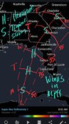
Nice graphic. I’m curious as to why you are going with a more Western track.My rough 1st thoughts
NoSnowATL
Member
Nice graphic. I’m curious as to why you are going with a more Western track.

Trough continues to trend slower.

Franklin also impacting with the western trade winds where it will slow the northeastern turn on TD10.
Shaggy
Member
Imagine if Franklin was 500 miles further west and we were looking around an east coast and a gom hit. Things would be going crazy in here
JHS
Member
GSP has been talking about a possible PRE event in their AFD's.It does look to be moving fairly quickly when it makes landfall. One problem is though that with the stalled out front and the flow in front of the storm is that there could be very heavy rainfall setting up well out ahead of the storm… so some areas could see as long a duration rain event as you see with a slow moving TC
Brent
Member
Imagine that the recon obs are way stronger than the advisory
That's life in the Carolina's. Whatever trend brings you the least action usually happens.Tropical Cyclone forecast track SE trend right on queue:
View attachment 136490
View attachment 136491
Brent
Member
Observations from a NOAA Hurricane Hunter aircraft indicate that
Tropical Depression Ten has strengthened into Tropical Storm Idalia.
The maximum winds are estimated to be 40 mph (65 km/h) with higher
gusts.
Tropical Depression Ten has strengthened into Tropical Storm Idalia.
The maximum winds are estimated to be 40 mph (65 km/h) with higher
gusts.
I don’t get it. Shouldn’t the fact that it has been lingering and not moving mean that it’s more likely to miss the front that’s coming through to push it east?That's life in the Carolina's. Whatever trend brings you the least action usually happens.
Not really the slower it goes the more east it'll go. We didn't want to see that south movement overnight. It delays landfall and gives the trough more time to kick it east. Missing the trough altogether, which is almost impossible at this point probably wouldn't give a desirable outcome either. It'd probably just drift around and get pushed west then.I don’t get it. Shouldn’t the fact that it has been lingering and not moving mean that it’s more likely to miss the front that’s coming through to push it east?