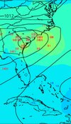
• Hello, please take a minute to check out our awesome content, contributed by the wonderful members of our community. We hope you'll add your own thoughts and opinions by making a free account!

Tropical Hurricane Idalia

Aren’t typically the wettest part of a tropical system the east side? For eastern Alabama and western Georgia to get the best chance of beneficial rains, we need it as far west as possible?
This is typically not the case with Gulf storms once they make landfall… the axis of heaviest rain is to the north and northwest of where the center passes. To the east and northeast of the center is where you have the biggest tornado threat.
 
Pretty good environment depicted on the GFS. The trough over the western GOM may impart some SW shear, but it may stay far enough west.

1693065568273.png
 
It does seem to be getting organized ahead of schedule and over open waters. It may become a tropical depression by late tomorrow and then we have a better idea of where it might be going and how strong this tropical system will become.
Just to the naked eye I think we probably have a TD later today. I’m not sure what the recon schedule is, but I’m sure they just want to verify a closed circulation.
 
Pretty good environment depicted on the GFS. The trough over the western GOM may impart some SW shear, but it may stay far enough west.

View attachment 136454
Something else to watch for inland rainfall effects is how long that front stalls out across the Carolinas. That might already be a focus point if heavy rainfall early in the week and could enhance rainfall later in the week if any moisture from a tropical system gets drawn into as well.
 
2. SUSPECT AREA (NW CARIBBEAN - AL93)
FLIGHT ONE - NOAA 43 FLIGHT TWO - TEAL 71
A. 27/1400Z A. 27/1500Z
B. NOAA3 01DDAA TDR B. AFXXX 02DDA INVEST
C. 27/1000Z C. 27/1230Z
D. 21.3N 86.5W D. 21.3N 86.5W
E. 27/1330Z TO 27/1630Z E. 27/1430Z TO 27/1900Z
F. SFC TO 15,000 FT F. SFC TO 15,000 FT
G. TAIL DOPPLER RADAR G. LOW LEVEL INVEST

FLIGHT THREE - NOAA 49 FLIGHT FOUR - TEAL 72
A. 28/0000Z A. 28/0530Z
B. NOAA9 03DDA SURV B. AFXXX 0410A CYCLONE
C. 27/1730Z C. 28/0300Z
D. NA D. 21.8N 86.5W
E. NA E. 28/0500Z TO 28/0830Z
F. 41,000 TO 45,000 FT F. SFC TO 10,000 FT
G. SYNOPTIC SURVEILLANCE G. FIX

FLIGHT FIVE - NOAA 49 FLIGHT SIX - TEAL 73
A. 28/1200Z A. 28/1130Z,1730Z
B. NOAA9 0510A CYCLONE B. AFXXX 0610A CYCLONE
C. 28/0530Z C. 28/0900Z
D. NA D. 22.1N 86.5W
E. NA E. 28/1100Z TO 28/1730Z
F. 41,000 TO 45,000 FT F. SFC TO 15,000 FT
G. SYNOPTIC SURVEILLANCE G. FIX

FLIGHT SEVEN - NOAA 43
A. 28/1200Z
B. NOAA3 0710A CYCLONE
C. 28/1000Z
D. 22.1N 86.5W
E. 28/1130Z TO 28/1530Z
F. SFC TO 15,000 FT
G. TAIL DOPPLER RADAR
Recon going in tommorow.
 
This is typically not the case with Gulf storms once they make landfall… the axis of heaviest rain is to the north and northwest of where the center passes. To the east and northeast of the center is where you have the biggest tornado threat.
Thanks
 
Northwestern Caribbean Sea and Eastern Gulf of Mexico (AL93):
Showers and thunderstorms associated with an area of low pressure
located near the Yucatan Channel continue to gradually become
better organized. If this trend continues, advisories will be
initiated on this system later today.
 
Back
Top