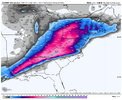
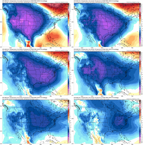
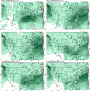
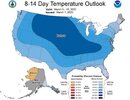
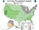
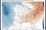
This has been the same look the entire Winter. They dig, tilt, get to strong & yeet into an oblivion. Texas & Arkansas. Rinse & repeat. Lol ?Not too bad how it turned out. Yes fantasy but still


-
Hello, please take a minute to check out our awesome content, contributed by the wonderful members of our community. We hope you'll add your own thoughts and opinions by making a free account!
You are using an out of date browser. It may not display this or other websites correctly.
You should upgrade or use an alternative browser.
You should upgrade or use an alternative browser.
Pattern Mega March 2023
- Thread starter SD
- Start date
rburrel2
Member
That upper level low snow falling in Dallas at 240hrs is -10C at 850 with upper 20s surface temps. And the low is just starting to pinch off at that point... it would have to go bowling ball and plow due east from there... it probably slows down to a crawl too with how things were evolving.
- Joined
- Jan 23, 2021
- Messages
- 4,601
- Reaction score
- 15,195
- Location
- Lebanon Township, Durham County NC
Cuts inland but it snow * A LOT * before it does.
- Joined
- Jan 23, 2021
- Messages
- 4,601
- Reaction score
- 15,195
- Location
- Lebanon Township, Durham County NC
Honestly thought the control run was going March 93 on us
Without digging into the details, given the track and backend anonymous cold, seems to have some similarities with the 93 Super Storm? No?
iGRXY
Member
LickWx
Member
Happy meteorological spring yall! 95% of us now have average highs above 60 (I think RDU goes over tomorrow or Friday). In one more month 70 is the average 
It's what makes me wonder whether or not -8 departures will give us a big snowstorm. 52 seems a tad too warm for snow, but there seems to be some enthusiasm about it, so I guess it's possible.Happy meteorological spring yall! 95% of us now have average highs above 60 (I think RDU goes over tomorrow or Friday). In one more month 70 is the average
Usmeagle2005
Member
It's what makes me wonder whether or not -8 departures will give us a big snowstorm. 52 seems a tad too warm for snow, but there seems to be some enthusiasm about it, so I guess it's possible.
Maybe it will hit at night???
ATLwxfan
Member
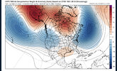
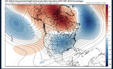
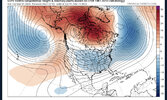
You can see the GEFS clearly lagging behind in showing lower heights out west while the EPS and GEPS continues to trend towards weaker heights and even a ridge trying to pop around 7-10 days out View attachment 133804View attachment 133805View attachment 133806
It gives me pause. The GEFS and GFS op are significantly more subdued as it pertains to the cold and the duration. That op run wasn’t impressive in the least. Though getting to normal and a little BN is a significant accomplishment compared to where we’ve been. I tend to think the Euro is overdoing things a bit.
Sent from my iPhone using Tapatalk
LickWx
Member
It is! March can still work though. Different than jan but it happens. Anything past mid March though is probably upper level low driven though? That seems to be the main big snow producer that time of year.It's what makes me wonder whether or not -8 departures will give us a big snowstorm. 52 seems a tad too warm for snow, but there seems to be some enthusiasm about it, so I guess it's possible.
iGRXY
Member
The GFS and its ensembles are hot garbage. It is on the biggest island by itself right now. Betting against the EPS especially at this range is not a good idea.It gives me pause. The GEFS and GFS op are significantly more subdued as it pertains to the cold and the duration. That op run wasn’t impressive in the least. Though getting to normal and a little BN is a significant accomplishment compared to where we’ve been. I tend to think the Euro is overdoing things a bit.
Sent from my iPhone using Tapatalk
Drizzle Snizzle
Member
In my mind if we don’t get anything by March 15 we’re done. It would take a once in a 40 or 50 year storm to get anything past March 15.It is! March can still work though. Different than jan but it happens. Anything past mid March though is probably upper level low driven though? That seems to be the main big snow producer that time of year.
NoSnowATL
Member
Hard to snow with temps around 37 too.Maybe it will hit at night???
i mean, awesome, looks good, but i've seen this general look from the euro ens snow map like 7 times this winter
packfan98
Moderator
Keep the banter in the Whamby thread folks. Thanks!
And nearly on the 30th anniversary of March ‘93…Not too bad how it turned out. Yes fantasy but still


I’ve seen it snow at 48It's what makes me wonder whether or not -8 departures will give us a big snowstorm. 52 seems a tad too warm for snow, but there seems to be some enthusiasm about it, so I guess it's possible.
Similar sfc low track. Some shortwave phasing on the Control. '93 more extreme phasing of course. No -NAO / Retrograding block in '93Without digging into the details, given the track and backend anonymous cold, seems to have some similarities with the 93 Super Storm? No?
I would put very little stock into the GFS suite… it has been performing horribly for months and the GFS op is basically useless outside of 4 days when it has no support from other modelsIt gives me pause. The GEFS and GFS op are significantly more subdued as it pertains to the cold and the duration. That op run wasn’t impressive in the least. Though getting to normal and a little BN is a significant accomplishment compared to where we’ve been. I tend to think the Euro is overdoing things a bit.
Sent from my iPhone using Tapatalk
GFS at 18z continues to be completely out to lunch compared to any other model and it’s ensemble group. Would put little to no stock in it at this point as a high amp phase 8 with blocking in the Arctic and westward retrograding -NAO does not support a pattern it’s laying out in the medium to long range. I think the euro/EPS cmc/GEPS have the right idea (and show similar pattern evolutions as a result) in how this evolution usually pans out with the pieces in play.
SnowNiner
Member
Doesn't look as good as last night. Backed off a bit.
ATLwxfan
Member
GFS at 18z continues to be completely out to lunch compared to any other model and it’s ensemble group. Would put little to no stock in it at this point as a high amp phase 8 with blocking in the Arctic and westward retrograding -NAO does not support a pattern it’s laying out in the medium to long range. I think the euro/EPS cmc/GEPS have the right idea (and show similar pattern evolutions as a result) in how this evolution usually pans out with the pieces in play.
It’s an outlier until we see if any of the other models follows suit. I get that it doesn’t make sense in regards to where the indices are headed but how could it be this far off? Seems insane.
Sent from my iPhone using Tapatalk
Might be a little loud overnight around here
HRRR Lightning
View attachment 030123.mp4
HRRR Radar
View attachment 030123.mp4
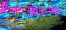
Total Precip
HRRR Lightning
View attachment 030123.mp4
HRRR Radar
View attachment 030123.mp4
Total Precip

Last edited:
- Joined
- Jan 23, 2021
- Messages
- 4,601
- Reaction score
- 15,195
- Location
- Lebanon Township, Durham County NC
The GFS is awful in every metric possibleIt’s an outlier until we see if any of the other models follows suit. I get that it doesn’t make sense in regards to where the indices are headed but how could it be this far off? Seems insane.
Sent from my iPhone using Tapatalk
Blue_Ridge_Escarpment
Member
Definitely has some quad 4 losses.The GFS is awful in every metric possible
Flotown
Member
just getting back for a few ,gotta get back focused on severe weather but got to say WOW at euro,taking verbatim...somebody gettin plastered...but lets see if it holds!!
No way anyone should believe this now. No need to get excited unless something is showing next Monday.
Hmmm, nice having CMC and Euro ensembles on the colder train with western trough ejection, but I don’t personally consider the GEFS a trash model - would rather have it closer to consensus
JHS
Member
Might be a severe storm or 2 also tonight. Marginal risk now over much of central and western NC for hail.Might be a little loud overnight around here
HRRR Lightning
View attachment 133821
HRRR Radar
View attachment 133822
Total Precip
View attachment 133823
Really I’d rather a moderate strength wave come out of the west first and hit the Mid-Atlantic / NE which then establishes the eastern trough behind it, then a have second moderate-strong wave slide west to east into cold air over the SENo way anyone should believe this now. No need to get excited unless something is showing next Monday.
The N and NW portions of the forum may prefer to swing for the fences like Mickey Mantle and have the first wave come out in Big Bang fashion per Euro Control (warmer risks)
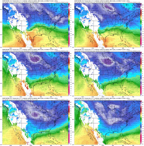
Tonight’s CMC holds strong with its previous runs. Exceptionally cold pattern for march. Impressive evolution hereReally I’d rather a moderate strength wave come out of the west first and hit the Mid-Atlantic / NE which then establishes the eastern trough behind it, then a have second moderate-strong wave slide west to east into cold air over the SE
The N and NW portions of the forum may prefer to swing for the fences like Mickey Mantle and have the first wave come out in Big Bang fashion per Euro Control (warmer risks)
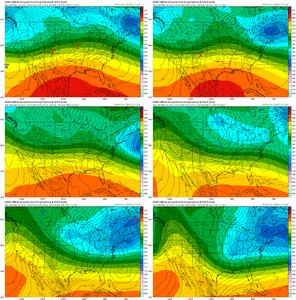
850 mb temp evolution is just insane for march. Below freezing all the way through Florida. That’ll support snow over the SE if you can get a system to show up in this time frameTonight’s CMC holds strong with its previous runs. Exceptionally cold pattern for march. Impressive evolution here View attachment 133833
Nice line of storms just left the area. Quite a bit of lightning/thunder. Moderate rain was almost heavy a few times. Best thing about the storms was it cleaned some of the gutters out. The rain went from 0 to 100 in a couple seconds.
Bye bye-bye pollen!! See you in a few days.
Bye bye-bye pollen!! See you in a few days.

