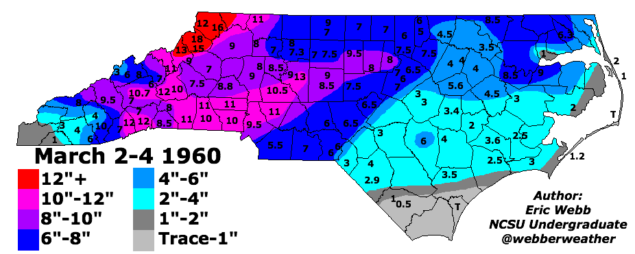
There's that March 1960 everyone loves to reminisce about.
-
Hello, please take a minute to check out our awesome content, contributed by the wonderful members of our community. We hope you'll add your own thoughts and opinions by making a free account!
You are using an out of date browser. It may not display this or other websites correctly.
You should upgrade or use an alternative browser.
You should upgrade or use an alternative browser.
Pattern Fail or Fab February 2023 Pattern Thread
- Thread starter RBR71
- Start date
D
Deleted member 609
Guest
There's that March 1960 everyone loves to reminisce about.
This JB guy is the anti LoganElliott
There's that March 1960 everyone loves to reminisce about.
I remember even March 2018 was so close to producing a big storm or two… just couldn’t get everything thing timed right. Even still CLT recorded trace snowfalls on 4 separate days
March 2018 is probably my 3rd favorite winter month since I moved out here. It got to a point by April I was bored with snowI remember even March 2018 was so close to producing a big storm or two… just couldn’t get everything thing timed right. Even still CLT recorded trace snowfalls on 4 separate days
Darklordsuperstorm
Member
This doesn't look good...
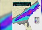
On this date,, 1973..
It’s been five decades since Wilmington picked up over a foot of snow in a 1973 storm.
The event began on February 9, 1973 and lasted through the following day.
Wilmington recorded 12.5″ of snow over the two-day storm.
1973 marks one of only two years the Port City has tallied more than a foot of snow.
Attachments
lexxnchloe
Member
We are due!!On this date,, 1973..
It’s been five decades since Wilmington picked up over a foot of snow in a 1973 storm.
The event began on February 9, 1973 and lasted through the following day.
Wilmington recorded 12.5″ of snow over the two-day storm.
1973 marks one of only two years the Port City has tallied more than a foot of snow.
Drizzle Snizzle
Member
Snow weenies in Atlanta were not happy that day.On this date,, 1973..
It’s been five decades since Wilmington picked up over a foot of snow in a 1973 storm.
The event began on February 9, 1973 and lasted through the following day.
Wilmington recorded 12.5″ of snow over the two-day storm.
1973 marks one of only two years the Port City has tallied more than a foot of snow.
I was born a week prior to this amazing storm. 50 years later.... I'm still waiting for something very similar or better. The closest I've gotten was the February 12th, 2010 and January 10th, 2011 storms, respectively. Both storms produced 7 or more inches of snow. The former with around 9" and the latter at around 7 inches of snow.On this date,, 1973..
It’s been five decades since Wilmington picked up over a foot of snow in a 1973 storm.
The event began on February 9, 1973 and lasted through the following day.
Wilmington recorded 12.5″ of snow over the two-day storm.
1973 marks one of only two years the Port City has tallied more than a foot of snow.
Hopefully, I can one day witness a 1973 redux.
Absolute unit of a severe setup coming together for late next week...
Darklordsuperstorm
Member
Does a mod wanna fire up a thread?Absolute unit of a severe setup coming together for late next week...

Cbmatt2408
Member
You know something is coming when they throw a 15% on a Day 7.Does a mod wanna fire up a thread?
View attachment 132871
Long Range: We can't stick a fork in winter just yet: waiting on the models to tell me to go ahead. GFS continuously barks for mischief Feb22-24. Granted I don't look at H5 reasons, ensembles and I should. went quite for the first time in several cycles at 6z. We will see if it comes back.
The CFS does the same first week of March. Shows a cold blast or two rolling through. So maybe we catch something on one of the last few cold fronts that whip through. Climo clock starts winding down past valentines Day. Got 4 good weeks left here in my neck of the woods. Then thats it outside some rogue circumstances that present themselves on average about every 20 years.

The CFS does the same first week of March. Shows a cold blast or two rolling through. So maybe we catch something on one of the last few cold fronts that whip through. Climo clock starts winding down past valentines Day. Got 4 good weeks left here in my neck of the woods. Then thats it outside some rogue circumstances that present themselves on average about every 20 years.
Eps and gefs continue to hint at a -nao and likely a high latitude blocking episode getting going the last 8-10 days of the month and going through a good part of March. I'm concerned it'll be too late and the pacific will only be marginally favorable.
Last edited:
SnowNiner
Member
Eps and gefs continue to hint at a -nao and likely a high latitude blocking episode getting going the last 8-10 days of the month and going through a good part of March. I'm concerned it'll be too late and the pacific will only be marginally favorable.
I have such little faith for anything in March, even in a good pattern. But if we can get the pacific to cooperate, AND, a 50/50 low for cad maybe we can sneak something in. This winter has made me want to keep hope longer than I normally would....even with frogs starting to croak at night, and trees starting to bud.
My thoughts may completely fail if so my bad but I think we make a run at 1 more opportunity maybe 2 before its over. My only concern is the pacific but we may have the tpv trapped in Canada do cold will at least be availableI have such little faith for anything in March, even in a good pattern. But if we can get the pacific to cooperate, AND, a 50/50 low for cad maybe we can sneak something in. This winter has made me want to keep hope longer than I normally would....even with frogs starting to croak at night, and trees starting to bud.
Just my gut and reading into everything that has been posted, but I feel real confident about at least one good event around here in March.My thoughts may completely fail if so my bad but I think we make a run at 1 more opportunity maybe 2 before its over. My only concern is the pacific but we may have the tpv trapped in Canada do cold will at least be available
ATLwxfan
Member
Just my gut and reading into everything that has been posted, but I feel real confident about at least one good event around here in March.
Maybe but it’s so hard to bet against pattern persistence especially given how resilient it’s been since Christmas.
Sent from my iPhone using Tapatalk
A few thoughts....the upper level signal of the MJO (200VP 1st image below) hasn't gotten stuck in the Indian Ocean and Maritime Continent this winter like it sometimes does, especially during La Nina. It has kept on cycling around the equator from Fall thru Winter. But when it's been in 8-1-2 (e.g. late Nov into Dec and in Jan), we haven't gotten the response we're looking for (western ridging).Eps and gefs continue to hint at a -nao and likely a high latitude blocking episode getting going the last 8-10 days of the month and going through a good part of March. I'm concerned it'll be too late and the pacific will only be marginally favorable.
Moving forward, 8-1-2-3 are all good this time of year historically, and we're about to make another run thru those phases with the VP signal moving east out of the Maritime Continent (2nd image). Will it help to impart western ridging this time or does persistence win out?? Only thing I can throw out here is that we may have, for the first time since Fall, a legit disruption to the persistent lower level La Nina trade winds along the dateline upcoming (3rd image along 180 longitude)...so maybe that helps to shake things up a bit. Of course, we also want to see the SSW go bonkers and downwell forcefully into the troposphere for a better shot at legit -AO/-NAO (need more time to let that one marinate and see how it shakes out)
Pattern discussion beats trying to hold off northward surging 500mb lows and warm noses (I think)


00z runs of the GFS and NASA GEOS models show nice downwelling of the SSW from the upper stratosphere (e.g. 1 mb) to the top of the troposphere (i.e. tropopause, approx 150mb) during the 2/10 to 2/20 timeframe (i.e. via negative NAM values in orange on the images).Of course, we also want to see the SSW go bonkers and downwell forcefully into the troposphere for a better shot at legit -AO/-NAO (need more time to let that one marinate and see how it shakes out)
Judah Cohen says the model runs that we typically view (GEFS / EPS etc.) become more reliable at predicting the effects of the SSW on the weather pattern once the SSW reaches the tropopause, so around 2/20 on these images. Hopefully, this type of downwelling look continues (it may not).


Yes it will need to downwell fully into the troposphere or it will be for naughtgrit, doesn't it really need to get to the 500mb level to really have an impact on the pattern? Forgive my professional curiosity here.
SnowNiner
Member
Thanks Grit. Looking at the standard mjo plots, it never really looked like it got into the cold phases this year. Looks like it almost did, then died into the cod. Perhaps the reason we didn't get the western ridging was because the forcing signal wasn't strong enough to force an effect.A few thoughts....the upper level signal of the MJO (200VP 1st image below) hasn't gotten stuck in the Indian Ocean and Maritime Continent this winter like it sometimes does, especially during La Nina. It has kept on cycling around the equator from Fall thru Winter. But when it's been in 8-1-2 (e.g. late Nov into Dec and in Jan), we haven't gotten the response we're looking for (western ridging).
Moving forward, 8-1-2-3 are all good this time of year historically, and we're about to make another run thru those phases with the VP signal moving east out of the Maritime Continent (2nd image). Will it help to impart western ridging this time or does persistence win out?? Only thing I can throw out here is that we may have, for the first time since Fall, a legit disruption to the persistent lower level La Nina trade winds along the dateline upcoming (3rd image along 180 longitude)...so maybe that helps to shake things up a bit. Of course, we also want to see the SSW go bonkers and downwell forcefully into the troposphere for a better shot at legit -AO/-NAO (need more time to let that one marinate and see how it shakes out)
Pattern discussion beats trying to hold off northward surging 500mb lows and warm noses (I think)
And of course, early though it is, it's shown to do the same thing in a few weeks. ?? Any thoughts on why we really just cannot hang out in the cold phases the last several years? Or at least with any amplication that makes a difference?

NBAcentel
Member
To be fair we made the best passage possible jan 2022Thanks Grit. Looking at the standard mjo plots, it never really looked like it got into the cold phases this year. Looks like it almost did, then died into the cod. Perhaps the reason we didn't get the western ridging was because the forcing signal wasn't strong enough to force an effect.
And of course, early though it is, it's shown to do the same thing in a few weeks. ?? Any thoughts on why we really just cannot hang out in the cold phases the last several years? Or at least with any amplication that makes a difference?
View attachment 132927
SnowNiner
Member
To be fair we made the best passage possible jan 2022
Ah, didn't think that was in cold phases. Thanks. Just doesn't seem like we're in it much at all, and western ridging is very hard to come by.
You should just print this out and post it by the computer. That's virtually the predominate configuration of that image every year now.Thanks Grit. Looking at the standard mjo plots, it never really looked like it got into the cold phases this year. Looks like it almost did, then died into the cod. Perhaps the reason we didn't get the western ridging was because the forcing signal wasn't strong enough to force an effect.
And of course, early though it is, it's shown to do the same thing in a few weeks. ?? Any thoughts on why we really just cannot hang out in the cold phases the last several years? Or at least with any amplication that makes a difference?
View attachment 132927
ATLwxfan
Member
GEFS has a nice warm look by the end of the month and maybe just maybe we dry out a bit!
Sent from my iPhone using Tapatalk
Sent from my iPhone using Tapatalk
ATLwxfan
Member
Thanks Grit. Looking at the standard mjo plots, it never really looked like it got into the cold phases this year. Looks like it almost did, then died into the cod. Perhaps the reason we didn't get the western ridging was because the forcing signal wasn't strong enough to force an effect.
And of course, early though it is, it's shown to do the same thing in a few weeks.
Any thoughts on why we really just cannot hang out in the cold phases the last several years? Or at least with any amplication that makes a difference?
View attachment 132927

 Any thoughts on why we really just cannot hang out in the cold phases the last several years? Or at least with any amplication that makes a difference?
For whatever reason even in the right phases we don’t manifest the expected outcome. With how wet this Nina has been it’s pretty clear we have to rethink what is “typical” in terms of ENSO/indices/MJO.
Sent from my iPhone using Tapatalk
GEFS likes to be wrong in the short medium and long range. Warmth on average will continue for now but we continue to get cold troughs mixed into the medium range until a pattern can materialize that can keep the troughs in place out east. Example below of its long range and what ends up verifying as we get closer. Wavy and progressive. But I’m hoping a legit SSWE and better mjo progression can give us something more legit coming late February and into early and mid march. Regardless winter as a whole has sucked as we all know .. think we can still manage something in march though if we can get this stuff to materialize (at least in the upper south east regions)GEFS has a nice warm look by the end of the month and maybe just maybe we dry out a bit!
Sent from my iPhone using Tapatalk


NBAcentel
Member
Warmest signal in a long time ???

ATLwxfan
Member
00z runs of the GFS and NASA GEOS models show nice downwelling of the SSW from the upper stratosphere (e.g. 1 mb) to the top of the troposphere (i.e. tropopause, approx 150mb) during the 2/10 to 2/20 timeframe (i.e. via negative NAM values in orange on the images).
Judah Cohen says the model runs that we typically view (GEFS / EPS etc.) become more reliable at predicting the effects of the SSW on the weather pattern once the SSW reaches the tropopause, so around 2/20 on these images. Hopefully, this type of downwelling look continues (it may not).
This is key. Without this occurring, a SSWE is a moot point.
Sent from my iPhone using Tapatalk
Those MJO Phase diagrams are based on calculations of 3 fields in the tropics: 1) Location of cloudiness / convection (OLR), 2) Lower level winds (850mb zonal winds), and 3) Upper level winds (200mb zonal winds). Although the MJO has been cycling on a regular basis since Fall, it is true that those 3 fields have remained fairly locked in to an underlying La Nina footprint, so yeah, not seeing big amplitude on the left side of the circle.Thanks Grit. Looking at the standard mjo plots, it never really looked like it got into the cold phases this year. Looks like it almost did, then died into the cod. Perhaps the reason we didn't get the western ridging was because the forcing signal wasn't strong enough to force an effect.
And of course, early though it is, it's shown to do the same thing in a few weeks. ?? Any thoughts on why we really just cannot hang out in the cold phases the last several years? Or at least with any amplication that makes a difference?
View attachment 132927
That does make me think though of the old GaWx MJO research where he found that the coldest temperatures in the East were typically found when the MJO was within the circle (COD) on the left hand side (i.e. Phases 7-8-1-2). That's what we had in the 2nd half of last January (image below).
Anyway, La Nina + Warm Phases (4-5-6) yields a high probability of Eastern warmth (Retracted Pac Jet and -PNA tendencies). La Nina + Cold Phases (8-1-2) yields a better chance for Eastern cold, but by no means is it a high chance (better chance at extended Pac Jet and -EPO / +PNA tendencies)

CPCs 3-4 week outlook highlights the major uncertainty in the guidance due to the SSWE that will take place along with an MJO moving into a much better and more favorable position for this time of year. There could be little to no affect but they also highlight these sort of changes might not be seen on dynamical models this far out. Keep your eye out on models for late February into early march for sudden changes in the pattern as these events could create a better environment for a more favorable pattern to show up.
Itryatgolf
Member
If it happens too late, it won't matter how strong the ssw event is unless it's unreal cold.CPCs 3-4 week outlook highlights the major uncertainty in the guidance due to the SSWE that will take place along with an MJO moving into a much better and more favorable position for this time of year. There could be little to no affect but they also highlight these sort of changes might not be seen on dynamical models this far out. Keep your eye out on models for late February into early march for sudden changes in the pattern as these events could create a better environment for a more favorable pattern to show up.
tennessee storm
Member
As Webber mentioned before. Ssw can also spike the nao. So even more. Nothing is guaranteed it will help us get more coldIf it happens too late, it won't matter how strong the ssw event is unless it's unreal cold.
I believe it’s forecasted to take place very soon. March is fair game as it always is at least for the upper SE regions. MJO goes favorable late February and early march as well. Not too late at all. If this event happened in mid march .. that’s when things are too late and you get a cold rain AprilIf it happens too late, it won't matter how strong the ssw event is unless it's unreal cold.
ATLwxfan
Member
Long periods of warmth followed by moderating cool shots that die as they come east. Rinse and repeat. Would tap the breaks on a pattern change as we have been warm through MJO “cold phases” many a time during this marathon Nina.
Sent from my iPhone using Tapatalk
Sent from my iPhone using Tapatalk
Last edited:
Well our source regions are locked and loaded with cold. Can we tap it?


rburrel2
Member
They’ve been locked all winter, as in locked in place up north. Lol.Well our source regions are locked and loaded with cold. Can we tap it?
View attachment 133009
View attachment 133010
March could definitely be good though with how preserved the arctic air will be up until then.