-
Hello, please take a minute to check out our awesome content, contributed by the wonderful members of our community. We hope you'll add your own thoughts and opinions by making a free account!
You are using an out of date browser. It may not display this or other websites correctly.
You should upgrade or use an alternative browser.
You should upgrade or use an alternative browser.
Tropical Hurricane Ian
- Thread starter severestorm
- Start date
-
- Tags
- tropical
Belle Lechat
Member
- Joined
- Aug 29, 2021
- Messages
- 1,547
- Reaction score
- 1,224

Cary_Snow95
Member
smast16
Member
Yep, but supposedly they have a plan to move the dish.Is ILM radar the one with the tree issues?
Felt a decent gust within last half hour or so, airport reported 25 mph gust, the station in RR on the ECONet has recorded 22.5, metwannabe PWS 14  Lol
Lol
LolNo surprise at all, it would have to hook hard left right now for that not too happen and I'll not be shocked to see it a little NE of that
LickWx
Member
It’s a nor’easter now though. Not sure what benefit we are even getting with being further east at this point other than it being even more drizzly and miserable .No surprise at all, it would have to hook hard left right now for that not too happen and I'll not be shocked to see it a little NE of that
Cary_Snow95
Member
It looks like those that were skeptical of a hard left turn giving the steering mechanisms were correct. Wants to keep going north and just slightly feel the tug west
I think the core still has some tropical characteristics, so that could still be a little more impactful along the coast with exact landfall. It will also still have a core of stronger winds that exact landfall will determine where a few of the strongest gust are, overall it means nothing for you and I as far as our backyards go but I like tracking regardless of thatIt’s a nor’easter now though. Not sure what benefit we are even getting with being further east at this point other than it being even more drizzly and miserable .
Downeastnc
Member
Recon should be entering the system now, should know how tropical it still is, and what kind of winds it has especially at the surface...
LickWx
Member
Is there any chance it misses the hook inland?It looks like those that were skeptical of a hard left turn giving the steering mechanisms were correct. Wants to keep going north and just slightly feel the tug west
Downeastnc
Member
I do recall in Charley that the S side had some pretty violent downburst like wind gust as the dry air wrapped around the south side...nothing crazy but something to watch for...
Cary_Snow95
Member
Also helps enhance the rain numbers for us Central nc peepsI think the core still has some tropical characteristics, so that could still be a little more impactful along the coast with exact landfall. It will also still have a core of stronger winds that exact landfall will determine where a few of the strongest gust are, overall it means nothing for you and I as far as our backyards go but I like tracking regardless of that
Yep, plus with that thunderstorm activity in the center I bet it's still tropical at this point, hybrid sure but still tropical system. Idk if nor'easters have that much lightning in the center. Recon should give some good infoAlso helps enhance the rain numbers for us Central nc peeps
Downeastnc
Member
Wind is kicking up rather quickly here, probably 30-35 in gust now
BackThePack
Member
Do you find precip accuracy issues with your tempest? I find they do well with lighter/moderate rain, but heavy rain the totals are soooo bad.I hate that my best location for my tempest is still somewhat blocked from N and NE winds. I'm tempted to relocate today temporarily so I can get a better reading ?
Actually best I can tell precip has been fairly accurate, nothing glaring to me there that stands out.... I will say it got better once I turned the Rain Check feature off (I'm in rural area that seems less accurate when there aren't other stations close by)Do you find precip accuracy issues with your tempest? I find they do well with lighter/moderate rain, but heavy rain the totals are soooo bad.
Thanks 1300m!
I feel like so far the winds have been fairly calm here in apex .. not noticeable at all as of right now and barely seeing the trees sway.. assuming we have to wait to get into some heavier bands but we’ve had .5 so far here so that’s nice
iGRXY
Member
No rain on the radar but it’s pouring here
LickWx
Member

SPC keeps us in a slight risk today. It will be interesting to see how much of the warmer unstable air can be pushed inland. I kind of have my doubts that we will see anything but a brief waterspout or two, but we will see if anything can get spun up along the boundary.
Hurricane Ian is currently off the SC coast, tracking northward.
Surface winds remain northeasterly over land areas, with dewpoints
generally in the 50s and low/mid 60s. Offshore, buoy data suggests
a more moist/unstable air mass is present with dewpoints in the mid
70s. Scattered semi-discrete convection has been occurring in this
offshore regime, along with a few transient supercell structures.
Present indications are that the more moist/favorable air will be
transported inland by early afternoon, with sufficient CAPE to pose
a risk of surface-based storms across much of eastern NC. Satellite
imagery suggests dry air has been entrained into the circulation,
which might lead to pockets of stronger heating/destabilization.
However, the tornado threat should be restricted to areas where the
richest low-level moisture is present (at least low 70s dewpoints).
The area of concern for a few tornadoes will spread northward into
southeast VA tonight as Ian moves inland.
jaw719
Member
Just now getting some thunder
Stormsfury
Member
Checking in. Sustained 30 mph just had a couple gusts approaching 50mph. In the moat region after the first band of steady heavy rain... Approx. 2" so far estimated

And stronger
Downeastnc
Member
No one should be surprised by now that Ian is east of guidance lol...
NAM anyone? ?

It's going to be impressive around here this afternoon and evening. I'm not sure people are prepared for what we get
Assume that’s a typo with Beaufort ND, but still crazy it’s the only site with a 70F DP. It was 61 at the house when I left around 8, it’s 57 here at RDU proper per the Outback.

SnowNiner
Member
No one should be surprised by now that Ian is east of guidance lol...
I'm surprised that nhc continually hasn't read the writing on the wall and continued to forecast west and correct east. Seems like the entire life of the cyclone.
Stormsfury
Member
They actually did on the last advisory.I'm surprised that nhc continually hasn't read the writing on the wall and continued to forecast west and correct east.
Recon appears to have a center at 79.4W...


JHSs houseSo what exactly were most of the models missing that was making Ian go east of the track majority of the time? I’m curious and don’t know much about this stuff.
Downeastnc
Member
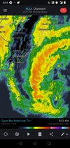
That NE quad fairly stout legit cane at the surface
Overdone right?
lexxnchloe
Member
Overdone right?
Sure it's overdone a bit but even 75% of that I probably lose power. The trends got us here, and you have certainly been on them the whole time and I commend you for that.
I mean either way I have everything charging and ready to go. I've had some flickers this morning. 1.22" on the tempest. Going to throw a steak on the griddle and enjoy whatever blows through.