generally was not expecting the post-florida ian to pack this much of a punch. i had posts dismissing it and i was wrong. good riddance to this storm, i much prefer being wrong about snowstorms
-
Hello, please take a minute to check out our awesome content, contributed by the wonderful members of our community. We hope you'll add your own thoughts and opinions by making a free account!
You are using an out of date browser. It may not display this or other websites correctly.
You should upgrade or use an alternative browser.
You should upgrade or use an alternative browser.
Tropical Hurricane Ian
- Thread starter severestorm
- Start date
-
- Tags
- tropical
It looks the eye is about to come ashore between Charleston and Myrtle Beach near Georgetown if that more westward trend continues. Ian has already put 1.38 inches of rain in the gauge and the winds are picking up.
Cary_Snow95
Member
I don’t know what to trust. Radar says it’s near Georgetown but maybe that’s not true center
Wind field spreading out considerably now, radar velocities 3k feet above my head are 60+ mph. Now don't expect any of that to mix down but for folks further SW of here should still see some 50 gust easily
JHS
Member
This is not headed for Mrytle Beach. If I am looking at the radar right, it's coming in near the Charleston, Georgetown county line headed just south of NW.
iGRXY
Member
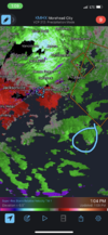
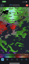
Radar looks WNW or almost due west and looks to be coming in at McClellanville as did Hugo. Those outer bands are finally clearing past Spartanburg county so there's definitely a much more west movement to it.
rambleon
Member
Seems like current general consensus is some possible stiff winds for rdu area… do we have a time frame at this point?
Weather Channel confirming this West movement incoming from multiple radar sites etc
Recon not really clearing this up for us either lol, probably due to the hybrid TC to ET transition going on. Dropsonde in the "eye" with 52kt NNW winds and pressure of 981. So that isn't the actual eye and apparently pressure still dropping


Did any model have it going due west like this?Weather Channel confirming this West movement incoming from multiple radar sites etc
SnowNiner
Member
Would that mean more wind or less wind for nc
Sent from my iPhone using Tapatalk
I think if it pulls straight west, gets closer to clt, higher winds and more rain for us. If not and it's continues north and east, more for Raleigh. Relatively speaking imo.
I've come to accept that Raleigh wins this one. I don't appreciate the trolling from Ian. Not cool storm.
Did any model have it going due west like this?
They had hard hooks off and on, but this is a little well, surprising. Lets see I spose'
Dude I can't recall, looked at so much stuff over the last few days but seems they did a little but further south before they started correcting north. But I don't think they showed it after those corrections up the coastDid any model have it going due west like this?
I bet it's headed back to Al
I think the RPM had it going WNW… bringing the center in just south of Myrtle Beach and inland towards Charlotte… it was probably the sharpest with the left hookDid any model have it going due west like this?
Stormsfury
Member
Convective tugging .. you can actually see it getting pulled into the band that's set up across middle Charleston County, Dorchester and Berkeley County. Have had several 55 mph wind gusts here.
Strongest winds so far
Folly Beach 83mph
Fort Sumter Light 73mph
Strongest winds so far
Folly Beach 83mph
Fort Sumter Light 73mph
Latest HRrrrRy shows it basically on a NNW heading through the sandhills. New run should be on deck soon
Something else that could be aiding this turn is that stout high to the north and the flow around it. I’ve figured for a couple days, that would at least help it bend back to the west someahhh yes 970s as we approach landfall .. western jog probably the result of the deep convection pulling it towards Charleston. Eventually should continue more north. View attachment 122654
Tornado Watch imminent for eastern NC, phone just went off, waiting for it to show up on the SPC.
Bouy about a few miles south of Me,,
Wind Direction (WDIR): NNE ( 30 deg true )
Wind Speed (WSPD): 35.0 kts
Wind Gust (GST): 40.0 kts
Atmospheric Pressure (PRES): 29.58 in
Pressure Tendency (PTDY): -0.13 in ( Falling Rapidly )
Air Temperature (ATMP): 70.9 °F
Water Temperature (WTMP): 73.0 °F
Wind Speed at 10 meters (WSPD10M): 36.9 kts
Wind Speed at 20 meters (WSPD20M): 38.9 kts
Cary_Snow95
Member
This center is impossible to track. Look at obs and where they recently had it I’m not convinced what we see on radar is the true center
Belle Lechat
Member
- Joined
- Aug 29, 2021
- Messages
- 1,529
- Reaction score
- 1,215
That water temperature, so cold.Bouy about a few miles south of Me,,
Air Temperature (ATMP): 70.9 °F
Water Temperature (WTMP): 73.0 °F
Stormsfury
Member
This deepening right before landfall and hitting the coast at perpendicular angle is gonna add to that storm surge to the right of where the center comes ashore. That happened two years ago at Oak Island with Isaias… I was there on vacation and we literally went in a matter of 8 hours from not even being in a hurricane warning to seeing the storm surge equivalent of a category 2 storm
lj0109
Member
- Joined
- Jan 23, 2021
- Messages
- 4,603
- Reaction score
- 15,199
- Location
- Lebanon Township, Durham County NC
Starting to see wind damage reports in the pee dee
Henry2326
Member
Icon and Nam forecasted 973. Let's see if that verifies.
Sctvman
Member
James Island getting slammed. 6-8“ of rain on most of the island and heavy wind bands. Gusting 60+
Hhhrrr still pretty rock solid bringing the system into NC tonight just west of the Triangle. Could be out to lunch idk
Much more consistent 30+ gusts here in the last half hour
lj0109
Member
I was looking at wind gust graphs for several of the weather models for Raleigh/Durham and all of them showed peak gusts for the storm over 50 miles per hour with the NAM and a couple of the other models over 60 MPH. Things could get interesting here if these models verify.
Many of the local forecasters are showing peak gusts at around 50 MPH. Whatever happens, things will be rocking and rolling some for the next ten hours or so in this area.
Many of the local forecasters are showing peak gusts at around 50 MPH. Whatever happens, things will be rocking and rolling some for the next ten hours or so in this area.
Looks decoupled, mid level rotation over land, surface still hasn't made landfall. Am I seeing that right? Tracking a hybrid is annoying almost as annoying as seeing gust that make the trees sway and my PWS recording a 14 mph gust ?Hhhrrr still pretty rock solid bringing the system into NC tonight just west of the Triangle. Could be out to lunch idk

