ForsythSnow
Moderator
Recon is, quite interesting. Don't think it's strong but recon is getting sub 990 pressure now at FL at the center so it's definitely below 994 at this point or so.
and no matter what upgrades they do it never improvesGFS returns are so trash man. It’s a shame it has this much of an issue painting a true reflectivity outside of 3 days.

Looks to me per the drop near the center it is 992 if I'm interpreting this correctly.Well extrapolated they're stating 999.7mb but graphics wise, that would look like 990ish.
View attachment 122080

Ha....that's a better indicator than the models.Jim Cantore is stationed in Clearwater.... what do y'all think?
So it will hit Destin Fla now.Jim Cantore is stationed in Clearwater.... what do y'all think?

The much expected RI may be beginning 992 mb and an eye View attachment 122081
Honestly track wise I’m gonna lean with the eastward leak will continue. Going with just south of Tampa.
Going to be correct. 992mb on last pass plus the RECON is reporting a C18 eye feature open on the W sideLooks to me per the drop near the center it is 992 if I'm interpreting this correctly.
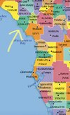
Could be right but I think it’s gonna be a little north north and west of that area. Somewhere around this yellow arrow.Honestly track wise I’m gonna lean with the eastward leak will continue. Going with just south of Tampa.
I’m waffling between 110-120mph. Agree with the weakening part; that or about to start.I'm around Tampa, just under a major, 974 and decaying, does appear though we have booster ignition and liftoff. Finally, about time, a major by this time tomorrow is on the table, Tampa area is definitely on watch, research shows only two majors to make landfall in the Bay Area directly over the past 150 years.
Jeff Piotrowski agrees with you. He said he thinks there will be evacuations in low lying areas starting tomorrow from Ft. Myers to Tampa. He is 90 percent sure major hurricane Ian will hit the area around noonish and later on Wednesday.Honestly track wise I’m gonna lean with the eastward leak will continue. Going with just south of Tampa.
I’m gonna take the blend of the models with a lean to the Euro camp and go a bit north of there near Cedar Key… though that can obviously change. That’s still gonna put Tampa in danger of a major storm surge, even from weakening storm as winds would be pushing water straight up the Bay for 12 hours or more.Could be right but I think it’s gonna be a little north north and west of that area. Somewhere around this yellow arrow.
60 mph and 991 mb.SUMMARY OF 800 PM EDT...0000 UTC...INFORMATION
----------------------------------------------
LOCATION...17.0N 80.8W
ABOUT 160 MI...260 KM S OF GRAND CAYMAN
ABOUT 430 MI...695 KM SE OF THE WESTERN TIP OF CUBA
MAXIMUM SUSTAINED WINDS...60 MPH...95 KM/H
PRESENT MOVEMENT...NW OR 310 DEGREES AT 12 MPH...19 KM/H
MINIMUM CENTRAL PRESSURE...991 MB...29.26 INCHES


It’s definitely getting that look now. I had a feeling Friday that it would take until sometime this afternoon or this evening to really start to see it get going… now that it looks like it is, it should be off to the races
This thing is not gonna cross Florida and come out the other side. It’s just not going to happen.
Why?This thing is not gonna cross Florida and come out the other side. It’s just not going to happen.
.png")
.png")
In fairness the ICON is a bit on its on island with that now. Even though a few EPS members still do it, more now are actually west of the mean. Of course two days ago the ICON was having it cross FL then become a fish storm, so slowly but surely it’s coming into line with othersWhy?
This is old? Right?
About 15 minsThis is old? Right?
Notice by landfall on all model sets there show somewhat significant weakening ..major hurricane to high end cat 1
I don’t really see any movement to the east compared to 18z… maybe the western plots have tightened up a bit to narrow the cone, but the eastern plots haven’t really moved all day. I think you’ll see the NHC stay pretty close to the previous forecast tracks at the 11pm update
That was the 12z gefs here is the 18z for comparisonAbout 15 mins

One thing to remember though is that even with the weakening, this still would create a significant to major storm surge. Tampa for instance, would see wind coming straight up the bay for at least 12 hoursNotice by landfall on all model sets there show somewhat significant weakening ..major hurricane to high end cat 1