Z
Zander98al
Guest
Good grief there's still projections into Louisiana ?
Good grief there's still projections into Louisiana ?
TVCN/X moved to Tampa.I don’t really see any movement to the east compared to 18z… maybe the western plots have tightened up a bit to narrow the cone, but the eastern plots haven’t really moved all day. I think you’ll see the NHC stay pretty close to the previous forecast tracks at the 11pm update
.png")
.png")
I understand that, but keep in mind that basically a 30-40 mile shift to the east of one plot. Now of course that 30-40 miles makes much more significant difference when it comes to landfall point, but the overall look of the plots remains fairly consistent to recent runs and it matches up well with the NHC forecast track and cone. Again, the NHC has been outstanding with forecasting landfall points the last few years and I expect that to continue.
Those west tracks though!!
I believe they follow the TVCN/X....I understand that, but keep in mind that basically a 30-40 mile shift to the east of one plot. Now of course that 30-40 miles makes much more significant difference when it comes to landfall point, but the overall look of the plots remains fairly consistent to recent runs and it matches up well with the NHC forecast track and cone. Again, the NHC has been outstanding with forecasting landfall points the last few years and I expect that to continue.
They absolutely do, but they also follow all the plots you see and use a blend depending on the support they have. Either way, it appears over the last 4 model cycles that a hit on the western Panhandle is looking less and less likelyI believe they follow the TVCN/X....
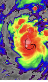
Is that the Yucatán to the left there?
?
 That looks like a kid colored all over it!
Oh wow! I just realized where the picture was from.
Oh wow! I just realized where the picture was from.


Track is way more east. This is increasingly looking like a big problem for Tampa
GFS. Shows no hurricane force gusts on coast
I think this is still a possibility.
based on how it looks right now I think it's a reasonable question to ask; "do the members that never bring it under 980 hold any forecasting value whatsoever"


 GEFS 18z vs 00z
That IR is smoking this morning. Sub-900mb or bust.Almost all modeling has the trough lifting out, stirring currents collapsing and Ian crawling along the Fl coast before the Atl ridge builds and kicks it N/NW inland. Still looks to be weakening at LF, which prob somewhere from Tampa to big bend area. ICON absolute outlier, determined the trough pulls it across Fl before slowing and turning NNW for 2nd LF around SC (it sucks we toss)
Also, it's starting to get that look this morning, probably put on a show today
.png")
.png")
.png")