accu35
Member
Dang gfs
And the ping-pong GFS continues.

Quite the fire hose setting up on the east side into NC

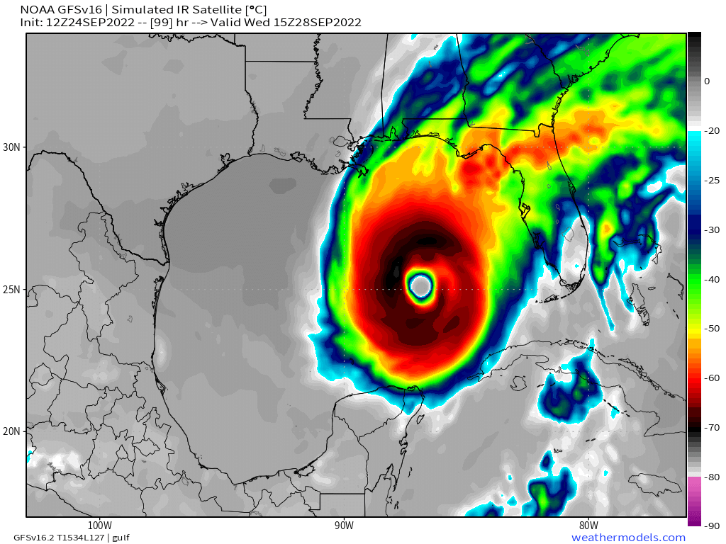
There have been similar changes with those models as the Gfs .. all westward trends continue as of right now. These I believe have more credit to them since model data has been getting recon data and environment data from extra weather balloons and hurricane hunter missions.ICON/UKmet/euro vs GFS
Sent from my iPhone using Tapatalk
There have been similar changes with those models as the Gfs .. all westward trends continue as of right now. These I believe have more credit to them since model data has been getting recon data and environment data from extra weather balloons and hurricane hunter missions.

Agreed… I don’t think we get a really good idea on total QPF until we get to short range models. This definitely has the ingredients to be a big time widespread eventExpect QPF to be underdone as well
Hopefully the Euro and Canadian models are right about precip. The GFS dry slots many of us and I'm afraid it may be right with the dry air wrapping around. It's a shame that the 70 degree dewpoints are long gone with this system possibly coming in. If this does miss, it'll be another 2+ weeks before we get another shot at any real rain.Agreed… I don’t think we get a really good idea on total QPF until we get to short range models. This definitely has the ingredients to be a big time widespread event
I would normally agree but we will have a LOT of dry air to overcome.Expect QPF to be underdone as well
Doesn’t really matter when Ian is acting to pull the moisture offshore over the Carolina’sI would normally agree but we will have a LOT of dry air to overcome.
Doesn’t really matter when Ian is acting to pull the moisture offshore over the Carolina’s
The GFS is having its normal convective feedback issues which is normal this far out. The fact is it’s showing a firehouse of moisture coming in over the top of a CAD… we all know that’s a recipe for heavy rainfallHopefully the Euro and Canadian models are right about precip. The GFS dry slots many of us and I'm afraid it may be right with the dry air wrapping around. It's a shame that the 70 degree dewpoints are long gone with this system possibly coming in. If this does miss, it'll be another 2+ weeks before we get another shot at any real rain.
No son, I want the rain up here and I'd like to keep the trees too. So all rain and no bite it perfect!Big rain with no wind in tropical systems is worse than cold and no snow

I do think this chart is hyperbole and I see your point. The real problem with charts like this is that many people who know little or nothing about the weather take forecasts like this as gospel rather than looking at other data and sources to make decisions. The NWS should be the first source that the public should go to for details on possible impacts from an approaching tropical system of any type.The chart conveys an overinflated degree of confidence with this storm in both track and intensity. There’s nothing here beneficial to the public that the NHC cone doesn’t bring. Nothing about this feels like a good faith effort to inform the public and instead just feels like clickbait. Charts like this give mets a bad name in my opinion and damage credibility. You’re technically not wrong but just because it could happen doesn’t mean it should be published
Trough strength ??


Still think GFS is too far west. I like the euro with very slow moves west but to think this thing goes any further west than big bend is still hard for me to buy right now .. especially with recon still having a hard time finding the exact center..


 HWRF has me in close to the center.
Will be some pretty impressive inland flooding and storm surge in the eastern panhandle if the HWRF OR HMON are correct. Honestly this would be devastating for this area as Michael ravaged this area a few years ago.HWRF and HMON shifting west, at same position, but not as far west as GFS.
HMON shredded on approach.
But....
HWRF at 955.....hope that doesn't verify.
View attachment 121960
View attachment 121961


