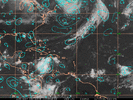
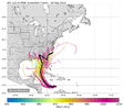
Probably be until tomorrow until the center competition ends.To my point, View attachment 121963
We need this pin pointed and locked down before we say which model has a better handle on things.. that’s 3 low level centers competing..
-
Hello, please take a minute to check out our awesome content, contributed by the wonderful members of our community. We hope you'll add your own thoughts and opinions by making a free account!
You are using an out of date browser. It may not display this or other websites correctly.
You should upgrade or use an alternative browser.
You should upgrade or use an alternative browser.
Tropical Hurricane Ian
- Thread starter severestorm
- Start date
-
- Tags
- tropical
And if the models keep shifting it further west, that would mean more time in the Gulf and more time to strengthen before landfall.
SimeonNC
Member
Has there ever been a CAD during a TC before? Because that seems new lol
Sent from my LM-Q730 using Tapatalk
Sent from my LM-Q730 using Tapatalk
If the west trend continues, it would actually weaken before landfall in the northern Gulf. There is strong wind shear in the northern Gulf that would weaken Ian.And if the models keep shifting it further west, that would mean more time in the Gulf and more time to strengthen before landfall.
Cary_Snow95
Member
Not really. The further west it goes the more shear and dry air will impact it as it approaches the coastlineAnd if the models keep shifting it further west, that would mean more time in the Gulf and more time to strengthen before landfall.
It’s not going to strengthen with more time in the Gulf. Whether this were to come in near the Big Bend or even back towards Mobile, the environment is not going to be conducive for the strengthening once it goes a certain point north. This will likely be down to at most a borderline cat 1-2 on near the Florida panhandleAnd if the models keep shifting it further west, that would mean more time in the Gulf and more time to strengthen before landfall.
Great point. And as we have (others on here) gfs is picking up on a different vote and taking off with it. Competing centers will not do this any favors right now for track and strengthTo my point, View attachment 121963
We need this pin pointed and locked down before we say which model has a better handle on things.. that’s 3 low level centers competing..
I mentioned this yesterday, but got the name wrong. Kate in 1985 hit the Florida panhandle and moved inland over GA and the eastern Carolinas before emerging in the Atlantic off the NC coast. There was a CAD in place out ahead with temperatures mainly in 50s and even some upper 40s in the CAD areas. That was in November however and only a few days before ThanksgivingHas there ever been a CAD during a TC before? Because that seems new lol
Sent from my LM-Q730 using Tapatalk
Z
Zander98al
Guest
What always surprises me is how quick hurricanes in the past 5 years have bombed out in very short time. Always different conditions but if some models are pointing a possibility of something strong I find it a good idea to watch, so many southern snow events have followed outlier model forecasts so everything bears watching if it's mentioned at least to me. Just my opinion thoughIt’s not going to strengthen with more time in the Gulf. Whether this were to come in near the Big Bend or even back towards Mobile, the environment is not going to be conducive for the strengthening once it goes a certain point north. This will likely be down to at most a borderline cat 1-2 on near the Florida panhandle
No this would more than likely lead to more of a chance that shear and dry air gets entrained weakening the storm considerably before a landfall on the gulf coastAnd if the models keep shifting it further west, that would mean more time in the Gulf and more time to strengthen before landfall.
Stormsfury
Member
I actually remember Kate in 1985. The air mass was cool, stable but as Kate pulled in, the air immediately went muggy, warm, humid and with Kate's right side, things got really dicey for an hour or two with very strong winds and torrential rains. Was in middle school at that time.I mentioned this yesterday, but got the name wrong. Kate in 1985 hit the Florida panhandle and moved inland over GA and the eastern Carolinas before emerging in the Atlantic off the NC coast. There was a CAD in place out ahead with temperatures mainly in 50s and even some upper 40s in the CAD areas. That was in November however and only a few days before Thanksgiving
Stormsfury
Member
Probably going to see a process like 2 black holes spinning around each other before finally merging...Look at the low level convergence map. Which area takes over?
View attachment 121965
Yeah that’s somewhat a concern in the back of my mind as well. Overall I expect a steady weakening as the model guidance suggests, but I never feel confident or absolute in an intensity forecast vs a track forecast. Even now we have decent confidence in Ian being a FL hit its just a matter of where in FL it happens. My concern is we don’t know what Ian’s peak (strength) will be until it happens in real time. NHC is peaking Ian at a Cat. 3, however it’s not impossible Ian could peak as high as a 4/5 instead of dealing with a weakening Cat 1/2, you could be dealing with a weakening Cat. 2/3. Intensity forecasts can be very complex and challenging since not every tropical system reacts or behaves the same way in the same environment/conditions every time.What always surprises me is how quick hurricanes in the past 5 years have bombed out in very short time. Always different conditions but if some models are pointing a possibility of something strong I find it a good idea to watch, so many southern snow events have followed outlier model forecasts so everything bears watching if it's mentioned at least to me. Just my opinion though
Drizzle Snizzle
Member
Opal was a Cat 5 i believe and weakened to a Cat 3 at landfall. Could this be similar to Opal ?
You are probably right. Heck recon really can’t find a good closed (with a true west wind) circulation it appears.Probably going to see a process like 2 black holes spinning around each other before finally merging...
Henry2326
Member
Z
Zander98al
Guest
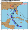
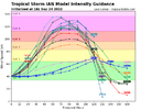
Hwrf follows trend with the 48 hour bomb. From cat 1 to cat 4 in it's projection lol.18z ......Looks like HWRF might have the right idea.
Moved west and intensity increased.
View attachment 121966
View attachment 121967
NHC still has it as a major hurricane at landfall.What always surprises me is how quick hurricanes in the past 5 years have bombed out in very short time. Always different conditions but if some models are pointing a possibility of something strong I find it a good idea to watch, so many southern snow events have followed outlier model forecasts so everything bears watching if it's mentioned at least to me. Just my opinion though
Hwrf follows trend with the 48 hour bomb. From cat 1 to cat 4 in it's projection lol.
And we have seen this happen frequently with systems in the Gulf the last few years.
Tornadocane
Member
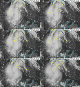
This battle between areas that want to become the dominant COC is pretty amazing. You have the one further SW with some Mid-Level Vorticity producing convection, and then you have the one trying to get going North of 15 Degrees that has had intense convection producing lightening. Clearly the best instability is towards the North. The strongest instability and better upper level environment is clearly on the North Side.
This looks like it's going to blow up at any second.
This looks like it's going to blow up at any second.
Tornadocane
Member
BHS1975
Member
Yeap definitely looks to be tightening up.
Sent from my iPhone using Tapatalk
Let’s see what takes over
vsublazer
Member
Tornadocane
Member
Yeap definitely looks to be tightening up.
Sent from my iPhone using Tapatalk
Oh Yeah. Oh Yeah. This is going to organize quickly. Every frame looks like the system is about to get stacked. You can see the clouds at various levels starting to flow in the same general direction. Though it's tougher to see the lower levels now. Recon is going to find a completely different system on its next journey.
Z
Zander98al
Guest
Slower consolidation of a center has really encouraged this westward track. I think you'll probably see a few more westward ticks until it's Conjealed.
Ian is crossing the west Caribbean under very good conditions, it’s definitely gonna bomb.And we have seen this happen frequently with systems in the Gulf the last few years.
Tornadocane
Member
| 14.567N 76.550W | 1006.0 mb |
JHS
Member
Irma had it. Temps were in the upper 50's here as it went through the area.Has there ever been a CAD during a TC before? Because that seems new lol
Sent from my LM-Q730 using Tapatalk
Actually more time to get sheared and ingest dry air.And if the models keep shifting it further west, that would mean more time in the Gulf and more time to strengthen before landfall.
The sky is the limit in the west Caribbean and Yucatán channel. There is a reason why monsters like Allen, Gilbert, Wilma, Emily, Ivan, Mitch and Dean roamed here. If this can get a solid core developed, a show is nearly guaranteed.
The sky is the limit in the west Caribbean and Yucatán channel. There is a reason why monsters like Allen, Gilbert, Wilma, Emily, Ivan, Mitch and Dean roamed here. If this can get a solid core developed, a show is nearly guaranteed.
I think we're going to see it strengthen rapidly like so many others have down there.
That matches the satellite presentation rather well too. I think this is the one.
14.567N 76.550W 1006.0 mb
Tornadocane
Member
| 19:55:00Z | 14.817N 76.283W | 1005.8 mb (~ 29.70 inHg) |
Recon is creeping NE.
Tornadocane
Member
That matches the satellite presentation rather well too. I think this is the one.
I agree. There is just so much instability in that area.
The devil is in the details.. most of these models have a landfall around 120 which you can see a majority of the models begin to significantly reduce the strength of the hurricane. This will be unlike our usual rapid intensifications up until landfall where we will probably see a beauty of a storm over water which then gets shredded and beaten up before landfall. Impacts will still be high though regardless but certainly good to see if you are living near the landfall location.18z ......Looks like HWRF might have the right idea.
Moved west and intensity increased.
View attachment 121966
View attachment 121967
Tornadocane
Member
| 15.000N 76.100W | 1005.7 mb (~ 29.70 inHg) | - |
I know no King but the King on 15N whose name is Ian. I
Stormsfury
Member
Looking over visible satellite imagery loop, appears to be there's a larger centrifugal mechanism gyre around 14.1°N, 77.0°W or so.

