It's not clean kick ots with the eastern most members and those turn north the earliest.

Why are models showing a bend back west into Carolinas? Are the feeling the effects of trough?It's not clean kick ots with the eastern most members and those turn north the earliest.
Yes. If you live in the Carolinas that short trip across FL back into the Atlantic then quick hook back into the coast is a concern if the trough is deeper into the upper south or across the Ohio Valley or it cuts offWhy are models showing a bend back west into Carolinas? Are the feeling the effects of trough?
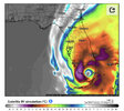
Yep, @SD answered it of course. And if you look at this image of the 12z Euro you can see interaction with that diving trough, even starting to tug it some but it's too late and basically pulls it back up into Atlantic Canada, but it's not far off from pulling it sooner. All depends on timing of both, TC and the trough, and how deep/location of that troughWhy are models showing a bend back west into Carolinas? Are the feeling the effects of trough?


Yes. If you live in the Carolinas that short trip across FL back into the Atlantic then quick hook back into the coast is a concern if the trough is deeper into the upper south or across the Ohio Valley or it cuts off

I think practically every one of these scenarios has been modeled in the past couple of days. LolThis may or may not be good for comparison. Everyone is so use to just seeing storms , once they hook NE head OTS. There's a few other tracks besides this one that shows you how the troughs coming and going/timing do some out of the norm stuff.
Talk about a hard right turn...Very impressive look on the Euro.

Stronger by a good bit as well
Ummm that would smack me with the northern wall eventuallyVery impressive look on the Euro.

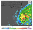
Convective feedback?Check out what the gfs is doing with the circulation early. It's either on to something or convective feedback blobs are biasing the early track SW meaning a W track View attachment 121791
As a resident of EI, we have the same interests.So, in Wilmington i can expect anything from sunny and pleasant to 100mph and no power.
Yep, @SD answered it of course. And if you look at this image of the 12z Euro you can see interaction with that diving trough, even starting to tug it some but it's too late and basically pulls it back up into Atlantic Canada, but it's not far off from pulling it sooner. All depends on timing of both, TC and the trough, and how deep/location of that trough
I haven’t been keeping up, when did you relocate to Pensacola?Ummm that would smack me with the northern wall eventually
I think he's in Port Saint Lucie. I could be wrong.I haven’t been keeping up, when did you relocate to Pensacola?
I think he's in Port Saint Lucie. I could be wrong.

Well I said between Panama City beach and Tampa look like the best landfall locations right now and sure enough, it’s smack right in the middle
It's crossing into some high wind shear in the northern Gulf. The Euro is a worse case scenario because it doesn't move in too much wind shear.

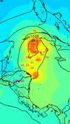
I was really hoping we would get a drought buster here in the upstate. Looking less and less likely. I’m tired of all these Eastern tracks.View attachment 121802
Updates hurricane models look like a perfect blend of the GFS and EURO
Tripping bruhThere's no way this storm is going to make a hard right turn like it's showing on the model guidance I seen this done before or I'm tripping
lolTripping bruh