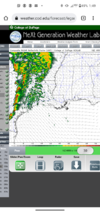
It's interesting how much faster the hrrr is at establishing the SB cape in that area vs say the 3kEven if not from the initial moisture plume you have possibly a good swath of near or at 1000j if sbcape that the HRRR shows during that time frame
-
Hello, please take a minute to check out our awesome content, contributed by the wonderful members of our community. We hope you'll add your own thoughts and opinions by making a free account!
You are using an out of date browser. It may not display this or other websites correctly.
You should upgrade or use an alternative browser.
You should upgrade or use an alternative browser.
Severe 3/21-3/24 Severe Weather
- Thread starter SD
- Start date
Z
Zander98al
Guest
HSVweather
Member
Z
Zander98al
Guest
Yeah, I actually kinda side with the HRRR. Moisture is always downplayed until you get within a day range, I'm afraid your highest tornado potential will actually be that western half of Alabama if that discreet convection that HRRR is showing gets going. It really made convection discreet in Texas for today when it was looking more like a line. It'll be a litmus test of what happens in TexasIt's interesting how much faster the hrrr is at establishing the SB cape in that area vs say the 3k
Z
Zander98al
Guest
See how the HRRR does with these, it'll be big in establishing confidence in the rouge storms over MS/AL tommorow.
HSVweather
Member
Z
Zander98al
Guest
NBAcentel
Member
It’s different aloft wind parameter wise in texas today vs tomorrow across the SEYeah, I actually kinda side with the HRRR. Moisture is always downplayed until you get within a day range, I'm afraid your highest tornado potential will actually be that western half of Alabama if that discreet convection that HRRR is showing gets going. It really made convection discreet in Texas for today when it was looking more like a line. It'll be a litmus test of what happens in Texas
Z
Zander98al
Guest
Even so, the accuracy of today's storms forecasted by the hrrr vs real time. will give higher confidence to tommorows prefrontal storms.It’s different aloft wind parameter wise in texas today vs tomorrow across the SE
Z
Zander98al
Guest
18z is being even more so bullish with warm sector prefront convection. Nvm that's to far ahead. Does have cells popping up near the qcls though.
HSVweather
Member
Z
Zander98al
Guest
That run of the 18z HRRR was a bit eye opening lol
HSVweather
Member
HSVweather
Member
I bet the chasers are going to get some good video this late afternoon evening.
There are several live streams available.
There are several live streams available.
Z
Zander98al
Guest
May have too much shear and rip the updrafts apart. with just 1000 cape
Just FYI, Pivotal Weather has added 0-3km UH to the WRFs and HRRR which is awesome as it’s been lacking on most sites for years. That said, the color scale is different value wise from the 2-5km UH maps. Just so everyone knows.
HSVweather
Member
Also, I may have missed it or been living under a rock but just noticed the models on pivotal under severe then combination plot have a SBCAPE/hodographJust FYI, Pivotal Weather has added 0-3km UH to the WRFs and HRRR which is awesome as it’s been lacking on most sites for years. That said, the color scale is different value wise from the 2-5km UH maps. Just so everyone knows.
Yeah same here. That is new as well.Also, I may have missed it or been living under a rock but just noticed the models on pivotal under severe then combination plot have a SBCAPE/hodograph
HSVweather
Member
Starting to get peeks of sun here...
HSVweather
Member
NoSnowATL
Member
Z
Zander98al
Guest
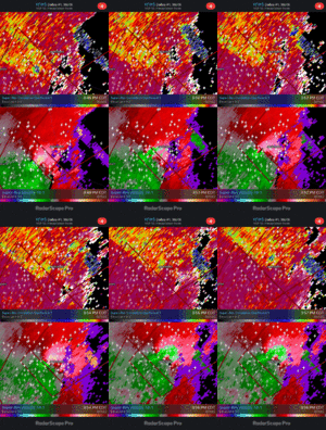
Pretty strong rotation
HSVweather
Member
Z
Zander98al
Guest
PDS warned now!
HSVweather
Member
HSVweather
Member
Z
Zander98al
Guest
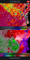
Looks like it got stronger after passing jacksboro. Deep blue on CC return.
Z
Zander98al
Guest
Probably a intense tornado, if I had to guess getting up near 20,000 range your near ef3 range maybe ef4.Stronger CC on next frame
View attachment 115993

