• Hello, please take a minute to check out our awesome content, contributed by the wonderful members of our community. We hope you'll add your own thoughts and opinions by making a free account!

Severe 3/21-3/24 Severe Weather

@Johnkittz @NoSnowATL, either post something of value or quit interacting within this thread on my posts. Y'all are becoming nothing more than annoying.
Zander, I learn alot from you and enjoy your input and your knowledge for weather. Don’t be discourage by others, keep doing what you do. Thank you for keeping us alert and ready for any danger headed our way.
 
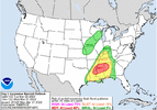
Junk fest with high end paramters lol. Even if just initially with convection popping you could have some significant tornadoes in that corridor. Apparently spc and nws see something that's ringing bells in there heads, maybe they have private models they use that indicate something we may not see.


Now that I think about it we had a similar event back int like april 2019 when I first joined it flopped big. Moderate risk into Louisiana and Mississippi. And ended up producing a ef3. But other than that nothing much.. Ineed to check that event I think this one is a bit different but that one was a incredibly bad slopfest that produced on the very southern end.
That’s why they get paid the big bucks… spc does this for living lol
 
Something stupid that happens on occasion is the northward pull of the warm sector isn't realized as much until you get about a day out, that being said, I think the worst of this event will be in the delta of MS into southwest Alabama. You may even get a clipped back risk area with it moving more southwest than the current SPC risk area. You'll probably see more shifts. If the mesolow becomes less evident you'll have more of a northward pull of that moisture but a tad less shear for rotation.
 
Big. Noticed this but didn't want to say anything, still in the long range HRRR runs. Get to about 18 hours and then that'll be pretty concerning. Not sure if your best parameters would be meshed well but still 2 days things will continue to refine.
 
Big. Noticed this but didn't want to say anything, still in the long range HRRR runs. Get to about 18 hours and then that'll be pretty concerning. Not sure if your best parameters would be meshed well but still 2 days things will continue to refine.

Kinda scary for my area
 
Kinda scary for my area
Where do you live? Based off all recent model runs parameters and severity will quickly drop going into Alabama. But again within 18 hours warm sectors can drastically change
 
Where do you live? Based off all recent model runs parameters and severity will quickly drop going into Alabama. But again within 18 hours warm sectors can drastically change
I think my area stands a chance at a moderate risk. I’m a hour north of Mobile. I live in Clarke Co. Jackson Al
 
That south Alabama / south Mississippi border region is looking like a sweet spot for discreet supercells. With it showing convection kicking off near noon. The circled area looks like your best bet for these. HRRRSE_prec_radar_042.pngScreenshot_20220320-204832-606.png
 
Begging to wonder if this is going to do your typical shift of a more eastern Mississippi into Alabama threat. Seems like it always happens where it will shift more into Alabama the closer it gets. Your best paramters still look like the delta but just something thats bouncing through my head right now. Its a pattern ive noticed.
 
Appears there is some rotating storms with the main line as it crosses the River. Seeing a few swaths close to my region in Northwest MS. Thinking SPC will need to extend their outlooks Northward with the overnight products.
0AF6F284-28C4-4AE4-87CC-3D9A780CB066.png
 
Appears there is some rotating storms with the main line as it crosses the River. Seeing a few swaths close to my region in Northwest MS. Thinking SPC will need to extend their outlooks Northward with the overnight products.
View attachment 115943
Yeah those caught my eye as well. Could see parts of North Mississippi go under an enhanced risk area. Don't think we'll go moderate+ due to the lack of CAPE.
 
Back
Top