BHS1975
Member
They didnt, there were 5-7 ft drifts everywhere, we could not stick a yardstick in the snow anywhere and still see it...
Yeap my folks Vega was buried.
Sent from my iPhone using Tapatalk
They didnt, there were 5-7 ft drifts everywhere, we could not stick a yardstick in the snow anywhere and still see it...
man that's sick, first time i've seen that reanalysis. my dad was in grad school at syracuse at the time and was driving back to wilmington for spring break- had a terrible car and by the time he hit SE NC the snow was deep enough to get stuck. he had car of marines from legeune behind him and whenever he'd get stuck they'd have to come out to help him push. wilmington has had a bunch of 2-4 inch events but man it would be sick for that area to get another big one soon.Yeah, I fixed it -- the one you quoted is the correct one.

Still think the western Carolinas and maybe NE GA can continue trending more favorably. Just don’t see this going much better for anyone west of there.


Could be at least some snow for all of NCStill Not bad ! View attachment 110462View attachment 110463
Dang, look at that deform band back in WNC18z Euro didn't improve on the front side...still has some snow on the backside
I was thinking that is worse for NE NC but it cuts off at 90 hours. They could really cash in.Euro actually looks decent in the NC Piedmont, driven from the northern stream View attachment 110464View attachment 110465

That SREF NMB was only 5mb off from being January 2000.

So the other one is weaker but not by much
I know it ain't much but can u show west??
Models have improved...maybe instead of 2 hours of time to prepare we'll have 2 days this timeThat SREF NMB was only 5mb off from being January 2000.View attachment 110471
")
Nothing really much west of the Savannah RiverI know it ain't much but can u show west??


It’s basically the ensembles on the NAM so it’s usually telling of what to expect from the upcoming NAM run. It’s still way outside of its range right now.How reliable is the SREF at this range? I don't know all that much about it.
The SREF is terrible. Believe it at your own peril.How reliable is the SREF at this range? I don't know all that much about it.
Thanks. So better range for it is 24-36hrs or so?It’s basically the ensembles on the NAM so it’s usually telling of what to expect from the upcoming NAM run. It’s still way outside of its range right now.
But it’s also matching well with other guidance of shifting things further and further west so it may not be in another solar system like it usually is.
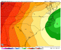
The rgem did great with Saturdays event and I will be eagerly watching it from here on in. If I can align with the gfs and the euro then I will start to feel better about this happening18z Op GFS v/s 18z EPS
Very impressive to be 84 hours out and literally on top of each other.
View attachment 110475
how much further west do you think that this storm will shiftIt’s basically the ensembles on the NAM so it’s usually telling of what to expect from the upcoming NAM run. It’s still way outside of its range right now.
But it’s also matching well with other guidance of shifting things further and further west so it may not be in another solar system like it usually is.

Well I will join you in bashing the SREF as I still have bad memories of February 2015… also I’m keeping my word and no longer bashing the ICON after it started the good trends to a decent snow for me last week… so I got to have a model to bash. That being said if the SREF is on to something here and I end up with a 3”+ snowfall out of this, I will no longer bash itThe SREF is terrible. Believe it at your own peril.
Ok, there's my obligatory SREF bash post since it worked last time. Gotta stay with what works.
On another note, we should start to see the Euro get a clue in the next day or so. It took it a while last time, poor thing.