LukeBarrette
im north of 90% of people on here so yeah
Meteorology Student
Member
2024 Supporter
2017-2023 Supporter
Keep shifting this west a little every run and a lot of people on this board are in for one.
Keep shifting this west a little every run and a lot of people on this board are in for one.


The lower heights / deeper blue is great there. That gives you lower temperatures aloft. Just need improved tilt to get more return flow / more moisture
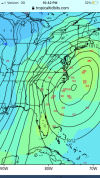
dynamic cooling needed?Cold air source to the northwest and not the northeast. Not a big fan tbhView attachment 110052
Seems like wet snow would be likely in this event.dynamic cooling needed?

Yeah, we won’t have the classic damming high in this setup. The key in terms of temperatures is that there is already a fairly deep trough in the eastern U.S. as the storm wave / trough moves in. If there was an extra day of delay, we most likely would be too warm. But if the base of the wave (500mb vort max) will get under us (track to our south) and be fairly deep / strong like this GFS run, we’ll have enough cold air aloft with temperatures at the surface around freezing after wet-bulbing / cooling with steady precipitation. Those components of the setup are akin to the Jan 1987 storm that hit the upstate - i.e. it had a Great Lakes low and no damming high to the north, but was just cold enoughCold air source to the northwest and not the northeast. Not a big fan tbhView attachment 110052
The majority of Miller A events have that look.Cold air source to the northwest and not the northeast. Not a big fan tbhView attachment 110052

We’ve been spoiled with our 25 degree snowstorms this month. It’s different staring a big one like this down the barrel knowing if everything goes right you’re temperatures will still be borderline marginal at best. But as Grit said, it’s been done before.dynamic cooling needed?
Yup. Lows definitely closer to the coast/FL. Some over FL.GEFS looking far more active

That’s very interesting..The majority of Miller A events have that look.
View attachment 110058

 Canadian looks west. Precip into GA/AL. Very close to an overrunning event.
HELLO.


Holy moly the change.View attachment 110063View attachment 110062Canadian looks west. Precip into GA/AL. Very close to an overrunning event.

Wow love seeing the ridge out west stack.