Cary_Snow95
Member
You have the means by chance?Something don’t sit right with both OPs south of there respective ensemble suites with the snow
You have the means by chance?Something don’t sit right with both OPs south of there respective ensemble suites with the snow
It’s still good, but more members had more IP/ZR further NWYou have the means by chance?


Yeah really its the perfect phase for central and eastern NC.....you can see the phasing actually tucks the 850's in much better probably giving everyone even better ratios thus increasing totals...great run for us.
View attachment 108141
Is this it? Should still be snowing at 84 rightIt’s still good, but more members had more IP/ZR further NW View attachment 108146View attachment 108147
Always conservative just like last timeWYFF currently doing with 1-2” for the upstate
Yeah I'm thinking NE/Central NC and SE VA look good right now, but I am concerned about mixing if this system becomes too amped. The RGEM and NAM crept freezing temperatures a little bit too northwest for me to be completely comfortable on the coast, as any system that gets too amped will cut out the coast from any freezing precipitation if it brings too much warmer maritime air ashore. Central NC won't have that issue because they'll probably stay below freezing at the surface for the whole event, but a more amped system = a stronger warm nose =more sleet/zr. Hoping for a stronger cold push at all levels from the surface up to 850.NE NC and SW Virginia are sitting in the sweet spot regardless of most situations. Unless the entire thing just went to hell in a hand basket. That is definitely one thing I’ll agree on. I’d be worried about the inevitable warm nose up that way potentially but that area definitely is sitting perfect as of right now
Still looked good but problem is the mean snowfall map counts everything as frozen and there was more of a pronounced warm nose on the GEFS. Still time to iron those details out but no fan of that showing up this earlyYou have the means by chance?
Still looked good but problem is the mean snowfall map counts everything as frozen and there was more of a pronounced warm nose on the GEFS. Still time to iron those details out but no fan of that showing up this early

Nothing wrong with First call maps we are within range. Gives me time for a final call map tomorrow night. I may up to 1” for Charlotte if the euro shows it we shall see!So why did you put out a Totals map yesterday LOL
Sent from my SM-A526U using Tapatalk
Let’s remember the GEFS ensemble is apart of the old GFS model they still haven’t made upgrades to the new Gfs ensembles there for im skeptical with anything they put out ..View attachment 108153
Sleet was definitely further north
I personally wouldn’t put much stock in the GFS thermals. Always go with NAM/RGEM blend. There’s going to be a lot more mixing than the GFS shows, GEFS have a lot more ice. Eastern Nc is likely going to be an ice rink with sleet and some zr.


 Gfs members at 72

 Gfs ens members at 78 look good
This is how to get a wonderful snowstorm in central NC even parts of the upstate
Well... the GEFS uses FV3 just like the GFS does.Let’s remember the GEFS ensemble is apart of the old GFS model they still haven’t made upgrades to the new Gfs ensembles there for im skeptical with anything they put out ..
What do you mean? Isn’t the Gfs the FV3?Well... the GEFS uses FV3 just like the GFS does.
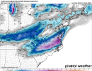
Yeah that GEFS Ens Mean map on WBell doesn't look right. It has the 540 thickness line on the bottom side of the sleet, when a general benchmark in this area for snow is 543 (i.e. south of the 540 line). The key is where do we go from here. A sharper northern stream wave that goes more negative tilt would make things warmer....if that doesn't happen, I'd say we are in pretty good shape here at the momentView attachment 108167Gfs ens members at 78 look good


NickyB beleive your right. I read that the other day, Gefs hasnt been upgraded, op has. Course the op still is in 4th 5th place. So we getting same lemon for our tax dollarsWhat do you mean? Isn’t the Gfs the FV3?
The GFS uses a FV3 core ever since 2019 as opposed to a spectral dynamic core. The GEFS was upgraded to match it in 2020. I figured that was what you were referring to by “old GFS”. All of the other US models (NAM, HAFS, HRRR, etc) are switching to an FV3 core as well.What do you mean? Isn’t the Gfs the FV3?


As long as the 0z euro doesn't go back to a big ice solution againYeah that GEFS Ens Mean map on WBell doesn't look right. It has the 540 thickness line on the bottom side of the sleet, when a general benchmark in this area for snow is 543 (i.e. south of the 540 line). The key is where do we go from here. A sharper northern stream wave that goes more negative tilt would make things warmer....if that doesn't happen, I'd say we are in pretty good shape here at the moment
The globals have a similar look with doing it mostly with the northern stream wave sharpening a bit and sliding west to east (UKMet is flattest with the wave it looks like and the most suppressed). The NAM/RDPS are incorporating the southern stream wave moreCMC looks as if it may have done it phasing wise instead of being close and missing like the GFS?
Even if not, there's more interaction between the two waves.
That low gonna have to be a lot closer then.....the thermals are different because the evolution is different....I have lived here my entire life and we have never had a ice storm with temps in the mid 20's with a low that far off Hatteras....it comes down to who has the 850 low track right, the GFS has it on the coast which makes sense if the surface low is 250 miles east of Hatteras....the NAM has it well inland but also has the surface low right off HAT....so the GFS is gonna have to correct back well west which is entirely possible but its thermals make total sense given its evolution.