- Joined
- Jan 2, 2017
- Messages
- 1,566
- Reaction score
- 4,279
And it's snowing again! This time in daytime

Gulf what do you think abt our temps. Snowing but struggling to accumulate

 Looks like heavy snow banding setting up in middle TN
Yeah sun just popped out over here in Alpharetta. Melting quickly ?
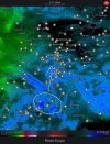
Yeah… that ULL is definitely still moving due east. It was forecasted cut before it reaches the AL/GA line and be further north when it did. I don’t think it going up the mountainsView attachment 106742Returns are starting to pop again near Montgomery. Hopefully this can pinwheel into ATL later.
 ️ over Tennessee are not headed East or we would be getting clocked instead of dry slotted tonight
Same here! Hug the gfs I guess?I have accumulation on the ground, but can't be more than .3 or so inches. The temps are definitely hindering things. Let's see how the rest of the day unfolds.
They’re stouter on the FFC radar. Regional radars are struggling to pick up anything beyond close range. I assume this is due to clutter from the snow but just guessing.Seems like those first few bands are getting tapped out as they cross the border.
Sent from my iPhone using Tapatalk

Very light flakes on the east side of town. Watching this area of heavier precip to the south of the Athens area. We will see if it holds together.The Athens airport (on the east side) says dew point is 35° with temps at 34.
Snow continues to fall pretty heavily on the west side I'm hearing reports that folks on the east side of town are seeing rain
.jpeg")
I'm on the northeast side of town. (Athens Tech area) it's been all snow since it turned from sleet. Big flakes sometimes. Tiny flakes now but steady. Accumulating on all surfaces but still melting some.The Athens airport (on the east side) says dew point is 35° with temps at 34.
Snow continues to fall pretty heavily on the west side I'm hearing reports that folks on the east side of town are seeing rain

Yeah in that neighborhood. I wanted to get a few more measurements in the open but it's ripping fatties of rain dropsWhat's that about .25-.3?
It's all melted here. Up to 36.Wonder if we may be done here for a while… melting away pretty quick


Yeah the flakes are dandruff sized and there’s not any mixing going on which seems to indicate temps are good for snow. But the rates are just so light it’s really melting quicker than it is falling at the moment.The issue here is we just haven't had the rates we first had with the changeover. I should have been brushing off an elevated surface every hour to take a measurement. I would speculate I've had between .5" and 1", but the rates are not enough to do anything but keep a perpetual coating on elevated surfaces.
32.4F/31.9