NBAcentel
Member
The UKIE has been terribly inconsistent this year. I like the 12z gfs the bestUKMET was about to bring the goods, run ended tho View attachment 76452View attachment 76453View attachment 76454View attachment 76455View attachment 76456
It Shears the wave out so any moisture is suppressed to the gulf coastEuro looks interesting at H 85, anybody have the surface?
All models have been terribly inconsistent or garbage this yearThe UKIE has been terribly inconsistent this year. I like the 12z gfs the best
Not necessarily a bad outcome at this point. I’m still not too optimistic given our current batting average this year.It Shears the wave out so any moisture is suppressed to the gulf coast
I’m not optimistic at all, but it’s probably one of our last chances, hopefully it trends better.Not necessarily a bad outcome at this point. I’m still not too optimistic given our current batting average this year.
Well the gfs and euro came back to reality on the 12z runs. I think all that hope is gone nowIf we manage a miracle and score with next week's system- and by scoring I mean board-wide with a 6 inch plus snow, (minus most of TN, MS, and part's of AL) sorry to you folks but you got yours already... I won't complain about winter or lack thereof for at least 2 years. I am a little more optimistic about next week than I have been in a while because we are in the midst of transitioning from winter to spring meaning we may be able to pull a big dog. But I won't bite until it showing this storm at least 48 hours in advance. And every damn model shows it. Lol.


Well the gfs and euro came back to reality on the 12z runs. I think all that hope is gone now
Thanks Doc, you answered exactly what I was asking. I know it’s been said many times but it does seem that often previous systems lay the groundwork for the ones that truly deliver in our area. Each subsequent system serving to drop the track a bit further south w the colder boundary in succession. I can rarely remember an event that wasn’t “wrestling the temps” here. Even w Arctic intrusion our systems only seem to be able to drop far enough south as air is moderating/boundary relaxing a bit. Then track of L pretty much means everything. I like that the track is becoming more favorable on heels of historic arctic to our west. Maybe we win one!! Thanks!!I’m a doctor not a meteorologist so I’m not the best person to explain it. Nice suppressed storm track with a gulf low and a big high over NE. Hopefully that bowling ball drops into Texas and stays nice and cold as it slides East. With marginal temps it’ll thread the line between heavy rain or snow. The whole “cooling the column” bit. There’s my awful explanation. Feel free to roll your eyes and toss.
Sent from my iPhone using Tapatalk
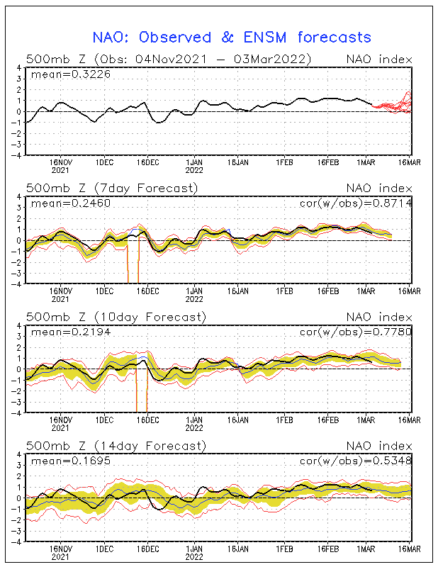
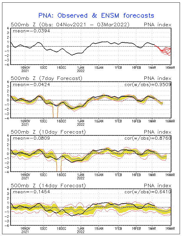
Y’all did so well with the -NAO, indices are trash and so is the MJO, as far as I’m concernedThe teleconnections right now doesn't look that good.

All we can ask for a week out is... are there players on the field?... right now there is.I could care less about any modeling this far out, to be honest. It's all noise and garbage at this point anyway. All I am looking for is a pattern that may open a window for one last hurrah for winter weather here. Then it's on to spring and svr weather. And I really hope we can manage to keep those wedges to our north. Because we all deserve something to track.
This makes me see red
This makes me see red
I’m not mad they saw snow. I’m mad that SAN ANTONIO can get 8 inches and we can’t even get a CAD to work over here.Why? Those kids never see snow like that they deserve to just as much as any kid. I'm happy for them. Our day will come.
We actually can get a cad to work. It gives us a 33 degree rain other than a 50-60 degree rainI’m not mad they saw snow. I’m mad that SAN ANTONIO can get 8 inches and we can’t even get a CAD to work over here.
Once in a lifetime storm most likelyLets not forget the march 1993 superstorm. Still lots of time.
I’m not mad they saw snow. I’m mad that SAN ANTONIO can get 8 inches and we can’t even get a CAD to work over here.
I tend to agree with this. The GFS had a better cold press into the eastern US but pretty much obliterated the shortwave incoming from the four-corners. A little more defined vort max and northern areas of the SE are in business.
This system for next Friday could very well come back. Most of our storms the models loose then bring back!
Sent from my iPhone using Tapatalk
I tend to agree with this. The GFS had a better cold press into the eastern US but pretty much obliterated the shortwave incoming from the four-corners. A little more defined vort max and northern areas of the SE are in business.
Really not bad at all. There seems to be a decent cold push there and there is a system. Again players are on the field. It obviously going to come down to near perfect timing. Is that likely?? No, but it has happened before
You barely beat me to it. I figured it might have been better for snow
Do you know if the EPS sucked with weak, suppressed systems or mid-Atlantic specials?
